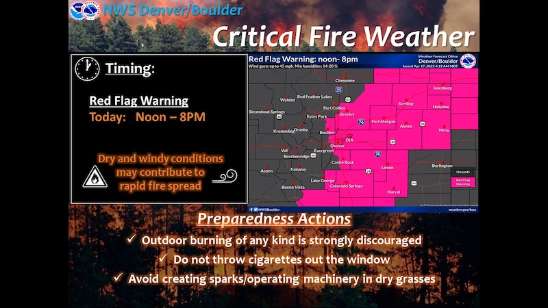
Red Flag Warning
URGENT - FIRE WEATHER MESSAGE
National Weather Service Denver/Boulder CO
337 AM MDT Sun Apr 17 2022
COZ239>241-245>247-172100-
/O.CON.KBOU.FW.W.0013.220417T1800Z-220418T0200Z/
Boulder And Jefferson Counties Below 6000 Feet/West Broomfield County-
North Douglas County Below 6000 Feet/Denver/West Adams and Arapahoe Counties/East Broomfield County-
Elbert/Central and East Douglas Counties Above 6000 Feet-
Central and East Adams and Arapahoe Counties-
North and Northeast Elbert County Below 6000 Feet/North Lincoln County-
Southeast Elbert County Below 6000 Feet/South Lincoln County-
337 AM MDT Sun Apr 17 2022
...
RED FLAG WARNING REMAINS IN EFFECT FROM NOON TODAY TO 8 PM MDT THIS EVENING FOR WIND AND LOW RELATIVE HUMIDITY FOR THE INTERSTATE 25 CORRIDOR AND THE PALMER DIVIDE.
* Affected Area...Fire Weather Zones 239, 240, 241, 245, 246 and 247.
* Timing...Sunday, 12 PM to 8 PM.
* Winds...Northwest 15 to 25 mph with gusts up to 35 mph.
* Relative Humidity...As low as 14 percent.
* Impacts...Any fire that develops will have the potential to spread rapidly. Outdoor burning should be avoided, as well as any activity that may produce a spark and start a fast moving wildfire.
PRECAUTIONARY/PREPAREDNESS ACTIONS...
A Red Flag Warning means that critical fire weather conditions are either occurring now....or will shortly. A combination of strong winds...low relative humidity...and warm temperatures can contribute to extreme fire behavior.