Red Flag Warning
URGENT - FIRE WEATHER MESSAGE
National Weather Service Denver/Boulder CO
Issued by National Weather Service Pueblo CO
728 AM MDT Tue Apr 19 2022
COZ215-216-238-241-242-246-247-192300-
/O.CON.KBOU.FW.W.0014.220419T1800Z-220420T0200Z/
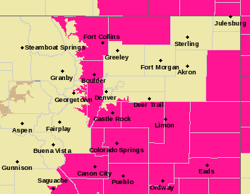
Larimer and Boulder Counties Between 6000 and 9000 Feet-
Jefferson and West Douglas Counties Above 6000 Feet/Gilpin/Clear
Creek/Northeast Park Counties Below 9000 Feet-
Larimer County Below 6000 Feet/Northwest Weld County-
Elbert/Central and East Douglas Counties Above 6000 Feet-
Northeast Weld County-
North and Northeast Elbert County Below 6000 Feet/North Lincoln County-
Southeast Elbert County Below 6000 Feet/South Lincoln County-
728 AM MDT Tue Apr 19 2022
...
RED FLAG WARNING REMAINS IN EFFECT FROM NOON TODAY TO 8 PM MDT THIS EVENING FOR WIND AND LOW RELATIVE HUMIDITY FOR THE FRONT RANGE FOOTHILLS MAINLY BELOW 7500 FEET AND THE CHEYENNE RIDGE, AS WELL AS THE PALMER DIVIDE INCLUDING EASTERN ELBERT AND LINCOLN COUNTIES...
* Affected Area...Fire Weather Zones 215, 216, 238, 241, 242, 246 and 247.
* Timing...Noon to 8 PM MDT today.
* Winds...Southwest 15 to 20 mph with gusts up to 35 mph.
* Relative Humidity...As low as 10 percent.
* Impacts...Any fire that develops will have the potential to spread rapidly. Outdoor burning should be avoided, as well as any activity that may produce a spark and start a fast moving wildfire.
PRECAUTIONARY/PREPAREDNESS ACTIONS...
A Red Flag Warning means that critical fire weather conditions are likely. A combination of strong winds...low relative humidity...and warm temperatures can contribute to extreme fire behavior.