From US National Weather Service Denver/Boulder:
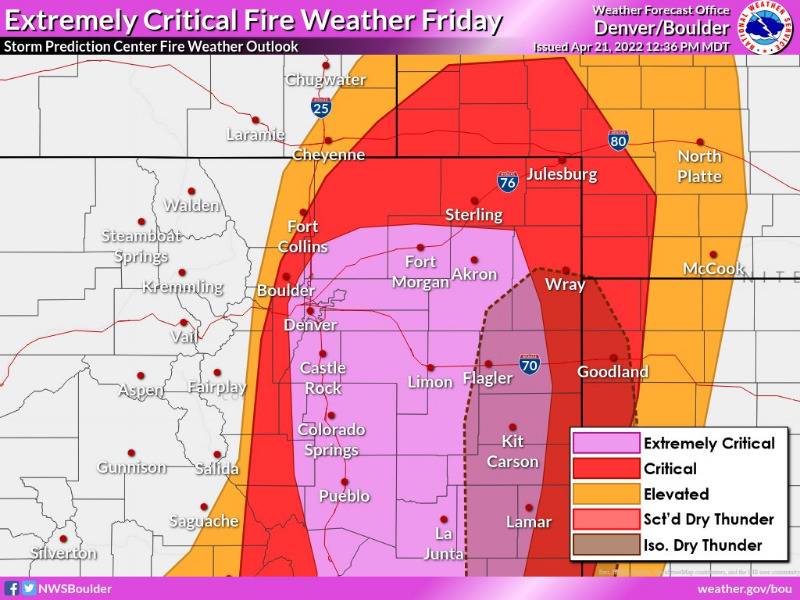
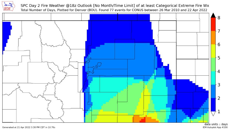
For another perspective on the rarity of this event, NOAA NWS Storm Prediction Center has placed most of our forecast area in a Day 2 Extremely Critical risk. Since 2010, this has only happened 1 other time in the Denver metro and a few times further south. PLEASE avoid ANY sparks tomorrow! #COwx #COFire
Red Flag Warning
URGENT - FIRE WEATHER MESSAGE
National Weather Service Denver/Boulder CO
300 PM MDT Thu Apr 21 2022
...EXTREMELY DANGEROUS FIRE WEATHER EPISODE ACROSS THE FOOTHILLS
AND PLAINS ON FRIDAY...
COZ215-216-238>251-220500-
/O.EXT.KBOU.FW.W.0017.220422T1400Z-220423T0300Z/
Larimer and Boulder Counties Between 6000 and 9000 Feet-
Jefferson and West Douglas Counties Above 6000 Feet/Gilpin/Clear Creek/Northeast Park Counties Below 9000 Feet-
Larimer County Below 6000 Feet/Northwest Weld County-
Boulder And Jefferson Counties Below 6000 Feet/West Broomfield County-
North Douglas County Below 6000 Feet/Denver/West Adams and
Arapahoe Counties/East Broomfield County-
Elbert/Central and East Douglas Counties Above 6000 Feet-
Northeast Weld County-Central and South Weld County-Morgan County-
Central and East Adams and Arapahoe Counties-
North and Northeast Elbert County Below 6000 Feet/North Lincoln County-
Southeast Elbert County Below 6000 Feet/South Lincoln County-
Logan County-Washington County-Sedgwick County-Phillips County-
300 PM MDT Thu Apr 21 2022
...
RED FLAG WARNING NOW IN EFFECT FROM 8 AM TO 9 PM MDT FRIDAY FOR EXTREME FIRE WEATHER CONDITIONS FOR THE SOUTHERN FRONT RANGE FOOTHILLS AND ALL OF THE PLAINS...FIRE WEATHER ZONES 215, 216, AND 238 THROUGH 251...
* Affected Area...Fire Weather Zones 215, 216, 238, 239, 240, 241, 242, 243, 244, 245, 246, 247, 248, 249, 250 and 251.
* Timing...
Winds will become strong in the morning into the early afternoon Friday, and then remain strong through the early evening hours. Humidities will plunge during this time as well.
* Winds...South 30 to 40 mph with gusts up to 65 mph.
* Relative Humidity...As low as 6 percent.
* Impacts...Any fire that starts will have the potential to spread rapidly, and would be difficult if not impossible to control. Avoid any and all outdoor activities that may produce a spark and start a fast moving and potentially destructive wildfire.
PRECAUTIONARY/PREPAREDNESS ACTIONS...
A Red Flag Warning means that critical fire weather conditions are either occurring now....or will shortly. A combination of strong winds...low relative humidity...and warm temperatures can contribute to extreme fire behavior.