Red Flag Warning
URGENT - FIRE WEATHER MESSAGE
National Weather Service Denver/Boulder CO
422 AM MDT Fri Apr 29 2022
...Critical Fire Weather Conditions Expected This Afternoon...
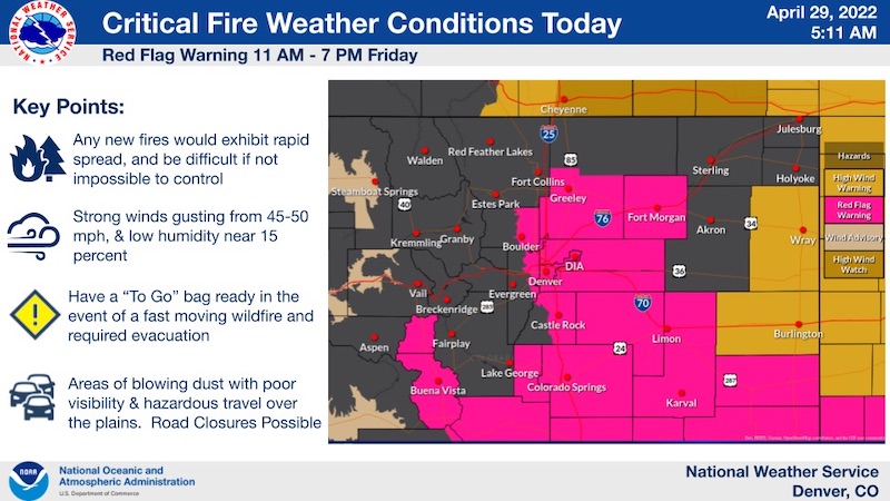
.Strong northwest winds are forecast to develop Friday and spread across the urban corridor and plains, with dry conditions during the afternoon leading to critical fire weather conditions. The highest danger will be over the southern plains where humidity will be particularly low, but given the forecast wind speeds, fire danger concerns still exist for areas north including the Denver metro and portions of the plains to the north and east despite more marginal humidity.
COZ239>241-243>246-300100-
/O.UPG.KBOU.FW.A.0012.220429T1700Z-220430T0100Z/
/O.EXA.KBOU.FW.W.0018.220429T1700Z-220430T0100Z/
Boulder And Jefferson Counties Below 6000 Feet/West Broomfield County-
North Douglas County Below 6000 Feet/Denver/West Adams and Arapahoe Counties/East Broomfield County-
Elbert/Central and East Douglas Counties Above 6000 Feet-
Central and South Weld County-Morgan County-
Central and East Adams and Arapahoe Counties-
North and Northeast Elbert County Below 6000 Feet/North Lincoln County-
422 AM MDT Fri Apr 29 2022
...
RED FLAG WARNING IN EFFECT FROM 11 AM THIS MORNING TO 7 PM MDT THIS EVENING FOR WIND AND LOW RELATIVE HUMIDITY FOR FIRE WEATHER ZONES 239, 240, 241, 243, 244, 245, AND 246...
The National Weather Service in Denver has issued a Red Flag Warning for wind and low relative humidity, which is in effect from 11 AM this morning to 7 PM MDT this evening. The Fire Weather Watch is no longer in effect.
* Affected Area...Fire Weather Zones 239, 240, 241, 243, 244, 245 and 246.
* Timing...11 AM to 7 PM Friday.
* Winds...Northwest 25 to 35 mph with gusts up to 55 mph.
* Relative Humidity...As low as 16 percent.
* Impacts...Any fire that starts will have the potential to spread rapidly, and could be difficult if not impossible to control. Avoid any and all outdoor activities that may produce a spark and start a fast moving and potentially destructive wildfire.
PRECAUTIONARY/PREPAREDNESS ACTIONS...
A Red Flag Warning means that critical fire weather conditions are either occurring now....or will shortly. A combination of strong winds...low relative humidity...and warm temperatures can contribute to extreme fire behavior.