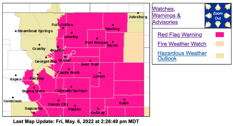
Red Flag Warning
URGENT - FIRE WEATHER MESSAGE
National Weather Service Denver/Boulder CO
227 PM MDT Fri May 6 2022
COZ239-240-243>245-249-071200-
/O.UPG.KBOU.FW.A.0013.220507T1600Z-220508T0300Z/
/O.NEW.KBOU.FW.W.0019.220507T1600Z-220508T0300Z/
Boulder And Jefferson Counties Below 6000 Feet/West Broomfield County-
North Douglas County Below 6000 Feet/Denver/West Adams and Arapahoe Counties/East Broomfield County-Central and South Weld County-Morgan County-Central and East Adams and Arapahoe Counties-Washington County-
227 PM MDT Fri May 6 2022
...
RED FLAG WARNING IN EFFECT FROM 10 AM TO 9 PM MDT SATURDAY FOR WIND AND LOW RELATIVE HUMIDITY FOR THE DENVER METRO AND PORTIONS OF THE EAST-CENTRAL PLAINS...
The National Weather Service in Denver has issued a Red Flag Warning for wind and low relative humidity, which is in effect from 10 AM to 9 PM MDT Saturday. The Fire Weather Watch is no longer in effect.
* Affected Area...Fire Weather Zones 239, 240, 243, 244, 245 and 249.
* Timing...10 AM to 9 PM MDT Saturday.
* Winds...Southwest 15 to 25 mph with gusts up to 40 mph.
* Relative Humidity...As low as 11 percent.
* Impacts...Any fire that starts will have the potential to spread rapidly. Avoid outdoor activities that may produce a spark and start a wildfire.
PRECAUTIONARY/PREPAREDNESS ACTIONS...
A Red Flag Warning means that critical fire weather conditions are either occurring now....or will shortly. A combination of strong winds...low relative humidity...and warm temperatures can contribute to extreme fire behavior.
_ _ _ _ _ _ _ _ _ _ _ _ _ _ _ _ _ _ _ _ _
URGENT - FIRE WEATHER MESSAGE
National Weather Service Denver/Boulder CO
227 PM MDT Fri May 6 2022
COZ214-216-241-246-247-071200-
/O.UPG.KBOU.FW.A.0013.220507T1600Z-220508T0300Z/
/O.NEW.KBOU.FW.W.0019.220507T1600Z-220508T0300Z/
/O.NEW.KBOU.FW.A.0014.220508T1700Z-220509T0300Z/
Central and Southeast Park County-
Jefferson and West Douglas Counties Above 6000 Feet/Gilpin/Clear Creek/Northeast Park Counties Below 9000 Feet-
Elbert/Central and East Douglas Counties Above 6000 Feet-
North and Northeast Elbert County Below 6000 Feet/North Lincoln County-
Southeast Elbert County Below 6000 Feet/South Lincoln County-
227 PM MDT Fri May 6 2022
...
RED FLAG WARNING IN EFFECT FROM 10 AM TO 9 PM MDT SATURDAY FOR WIND AND LOW RELATIVE HUMIDITY FOR THE PALMER DIVIDE, SOUTH PARK, AND PORTIONS OF EAST-CENTRAL COLORADO...
...FIRE WEATHER WATCH IN EFFECT FROM LATE SUNDAY MORNING THROUGH SUNDAY EVENING FOR WIND AND LOW RELATIVE HUMIDITY FOR THE PALMER DIVIDE, SOUTH PARK, AND PORTIONS OF EAST-CENTRAL COLORADO...
The National Weather Service in Denver has issued a Red Flag Warning for wind and low relative humidity, which is in effect from 10 AM to 9 PM MDT Saturday. A Fire Weather Watch has also been issued. This Fire Weather Watch for wind and low relative humidity is in effect from Sunday morning through Sunday evening.
* Affected Area...Fire Weather Zones 214, 216, 241, 246 and 247.
* Timing...Red Flag Warning in effect from 10 AM to 9 PM MDT on Saturday. Fire Weather Watch in effect from 11 AM to 9 PM MDT on Sunday.
* Winds...Southwest 15 to 25 mph with gusts up to 40 mph.
* Relative Humidity...As low as 10 percent.
* Impacts...Any fire that starts will have the potential to spread rapidly. Avoid outdoor activities that may produce a spark and start a wildfire.
PRECAUTIONARY/PREPAREDNESS ACTIONS...
A Red Flag Warning means that critical fire weather conditions are either occurring now....or will shortly. A combination of strong winds...low relative humidity...and warm temperatures can contribute to extreme fire behavior.
A Fire Weather Watch means that critical fire weather conditions are forecast to occur. Listen for later forecasts and possible Red Flag Warnings.