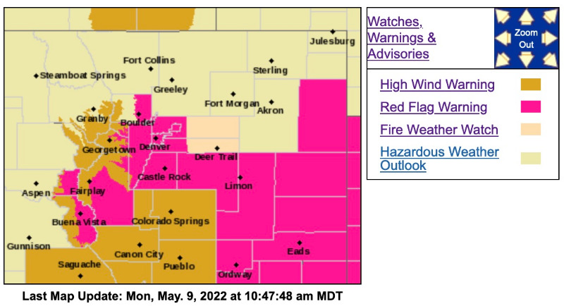
Red Flag Warning
URGENT - FIRE WEATHER MESSAGE
National Weather Service Denver/Boulder CO
359 AM MDT Mon May 9 2022
COZ214-216-241-091800-
/O.NEW.KBOU.FW.A.0016.220510T1700Z-220511T0300Z/
/O.CON.KBOU.FW.W.0020.000000T0000Z-220510T0300Z/
Central and Southeast Park County-
Jefferson and West Douglas Counties Above 6000 Feet/Gilpin/Clear Creek/Northeast Park Counties Below 9000 Feet-
Elbert/Central and East Douglas Counties Above 6000 Feet-
359 AM MDT Mon May 9 2022
...
RED FLAG WARNING REMAINS IN EFFECT UNTIL 9 PM MDT THIS EVENING FOR WIND AND LOW RELATIVE HUMIDITY FOR SOUTH PARK....THE SOUTHERN FRONT RANGE FOOTHILLS...AND PALMER DIVIDE AREA...
...
FIRE WEATHER WATCH IN EFFECT FROM TUESDAY MORNING THROUGH TUESDAY EVENING FOR WIND AND LOW RELATIVE HUMIDITY FOR SOUTH PARK...THE SOUTHERN FRONT RANGE FOOTHILLS...AND PALMER DIVIDE AREA...
The National Weather Service in Denver has issued a Fire Weather Watch for wind and low relative humidity, which is in effect from Tuesday morning through Tuesday evening.
* Affected Area...Fire Weather Zones 214, 216 and 241.
* Timing...Red Flag Warning in effect until 9 pm Monday, with the most significant conditions today.
* Winds...Southwest 25 to 35 mph with gusts up to 60 mph.
* Relative Humidity...As low as 10 percent.
* Impacts...Any fire that starts will have the potential to spread rapidly and would be difficult to control. Avoid burning or any outdoor activity that may produce a spark and start a wildfire.
PRECAUTIONARY/PREPAREDNESS ACTIONS...
A Red Flag Warning means that critical fire weather conditions are either occurring now....or will shortly. A combination of strong winds...low relative humidity...and warm temperatures can contribute to extreme fire behavior.
A Fire Weather Watch means that critical fire weather conditions are forecast to occur. Listen for later forecasts and possible Red Flag Warnings.
_ _ _ _ _ _ _ _ _ _ _ _ _ _ _ _ _ _ _ _ _ _ _ _ _ _ _ _ _ _ _ _ _ _ _
Red Flag Warning
URGENT - FIRE WEATHER MESSAGE
National Weather Service Denver/Boulder CO
359 AM MDT Mon May 9 2022
COZ239-091800-
/O.UPG.KBOU.FW.A.0015.220509T1600Z-220510T0300Z/
/O.EXB.KBOU.FW.W.0020.220509T1700Z-220510T0100Z/
Boulder And Jefferson Counties Below 6000 Feet/West Broomfield County-
359 AM MDT Mon May 9 2022
...
RED FLAG WARNING IN EFFECT FROM 11 AM THIS MORNING TO 7 PM MDT THIS EVENING FOR WIND AND LOW RELATIVE HUMIDITY FOR BOULDER AND JEFFERSON COUNTIES...
The National Weather Service in Denver has issued a Red Flag Warning for wind and low relative humidity, which is in effect from 11 AM this morning to 7 PM MDT this evening. The Fire Weather Watch is no longer in effect.
* Affected Area...Fire Weather Zone 239.
* Timing...From 10 am to 9 pm MDT on Monday.
* Winds...West 10 to 20 mph with gusts up to 35 mph.
* Relative Humidity...As low as 9 percent.
_ _ _ _ _ _ _ _ _ _ _ _ _ _ _ _ _ _ _ _ _ _ _ _ _ _ _ _ _ _ _ _ _ _ _
High Wind Warning
URGENT - WEATHER MESSAGE
National Weather Service Denver CO
434 AM MDT Mon May 9 2022
COZ034-091800-
/O.CON.KBOU.HW.W.0012.000000T0000Z-220509T1800Z/
South and Southeast Grand/West Central and Southwest Boulder/Gilpin/
Clear Creek/Summit/North and West Park Counties Above 9000 Feet-
Including the cities of Indian Peaks, Eisenhower Tunnel, East Slopes Southern Gore Range, Mount Evans, East Slopes Mosquito Range, Breckenridge, Winter Park, Williams Fork Mountains, Kenosha Mountains, and Berthoud Pass
434 AM MDT Mon May 9 2022
...
HIGH WIND WARNING REMAINS IN EFFECT UNTIL NOON MDT TODAY...
* WHAT...Southwest winds 35 to 45 mph with gusts up to 90 mph ongoing.
* WHERE...The Mountains of Summit County, the Mosquito Range, and the Indian Peaks.
* WHEN...Until Noon MDT today.
* IMPACTS...Damaging winds will blow down trees and power lines. Travel will be difficult over the high mountain passes, especially for high profile vehicles.
PRECAUTIONARY/PREPAREDNESS ACTIONS...
Winds this strong can make driving difficult, especially for high profile vehicles. Use extra caution.
For more information from the National Weather Service, visit
weather.gov/bou