From US National Weather Service Denver/Boulder Colorado:
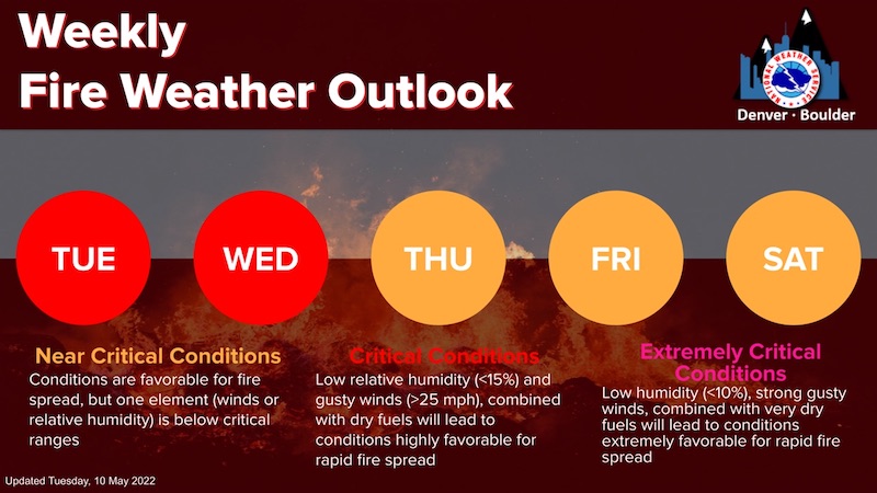
Above normal temperatures combined with dry conditions and increased wind speeds through the week will create near critical to critical fire weather conditions for the region. Near critical means that some but not all thresholds have been met for rapid fire spread but conditions are favorable. Critical means that conditions are met and if a fire starts rapid fire spread is probable.
Near Critical Conditions - Tuesday & Wednesday
Critical Conditions - Thursday
Extremely Critical Conditions - Friday & Saturday
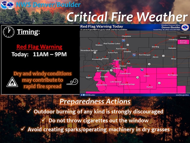
Red Flag Warning
URGENT - FIRE WEATHER MESSAGE
National Weather Service Denver/Boulder CO
430 AM MDT Tue May 10 2022
COZ214-216-241-246-247-101830-
/O.CON.KBOU.FW.W.0022.220510T1700Z-220511T0300Z/
/O.CON.KBOU.FW.A.0017.220511T1500Z-220512T0300Z/
Central and Southeast Park County-
Jefferson and West Douglas Counties Above 6000 Feet/Gilpin/Clear Creek/Northeast Park Counties Below 9000 Feet-
Elbert/Central and East Douglas Counties Above 6000 Feet-
North and Northeast Elbert County Below 6000 Feet/North Lincoln County-
Southeast Elbert County Below 6000 Feet/South Lincoln County-
430 AM MDT Tue May 10 2022
...
RED FLAG WARNING REMAINS IN EFFECT FROM 11 AM THIS MORNING TO 9 PM MDT THIS EVENING FOR WIND AND LOW RELATIVE HUMIDITY FOR FIRE ZONES 214, 216, AND 241...SOUTH PARK, THE SOUTHERN FRONT RANGE FOOTHILLS, AND EASTERN DOUGLAS AND WESTERN ELBERT COUNTIES...
...FIRE WEATHER WATCH REMAINS IN EFFECT FROM WEDNESDAY MORNING THROUGH WEDNESDAY EVENING FOR WIND AND LOW RELATIVE HUMIDITY...
* Affected Area...Fire Weather Zones 214, 216, 241, 246 and 247.
* Timing...Red Flag Warning in effect from 11 AM until 9 PM Tuesday. A Fire Weather Watch is in effect for Wednesday.
* Winds...South 20 to 30 mph with gusts up to 45 mph.
* Relative Humidity...As low as 9 percent.
* Impacts...Any fire that starts will have the potential to spread rapidly and would be difficult to control. Avoid burning or any outdoor activity that may produce a spark and start a wildfire.
PRECAUTIONARY/PREPAREDNESS ACTIONS...
A Red Flag Warning means that critical fire weather conditions are either occurring now....or will shortly. A combination of strong winds...low relative humidity...and warm temperatures can contribute to extreme fire behavior.
_ _ _ _ _ _ _ _ _ _ _ _ _ _ _ _ _ _ _ _ _
Fire Weather Watch
URGENT - FIRE WEATHER MESSAGE
National Weather Service Denver/Boulder CO
430 AM MDT Tue May 10 2022
COZ211-213-238>240-242>245-248>251-101830-
/O.CON.KBOU.FW.A.0017.220511T1500Z-220512T0300Z/
Jackson County Below 9000 Feet-
Grand and Summit Counties Below 9000 Feet-
Larimer County Below 6000 Feet/Northwest Weld County-
Boulder And Jefferson Counties Below 6000 Feet/West Broomfield County-
North Douglas County Below 6000 Feet/Denver/West Adams and Arapahoe Counties/East Broomfield County-Northeast Weld County-
Central and South Weld County-Morgan County-
Central and East Adams and Arapahoe Counties-Logan County-
Washington County-Sedgwick County-Phillips County-
430 AM MDT Tue May 10 2022
...
FIRE WEATHER WATCH REMAINS IN EFFECT FROM WEDNESDAY MORNING THROUGH WEDNESDAY EVENING FOR WIND AND LOW RELATIVE HUMIDITY FOR FIRE ZONES 211, 213, 238 THROUGH 240, 242 THROUGH 245, AND 248 THROUGH 251...THE NORTHEAST PLAINS, NORTHERN FRONT RANGE FOOTHILLS, AND NORTH AND MIDDLE PARKS...
* Affected Area...Fire Weather Zones 211, 213, 238, 239, 240, 242, 243, 244, 245, 248, 249, 250 and 251.
* Timing...Fire Weather Watch from 9 am to 9 pm Wednesday.
* Winds...South 15 to 25 mph with gusts up to 40 mph.
* Relative Humidity...As low as 11 percent.
* Impacts...Any fire that starts will have the potential to spread rapidly. Avoid burning or any outdoor activity that may produce a spark and start a wildfire.
PRECAUTIONARY/PREPAREDNESS ACTIONS...
A Fire Weather Watch means that critical fire weather conditions are forecast to occur. Listen for later forecasts and possible Red Flag Warnings.