Red Flag Warning
URGENT - FIRE WEATHER MESSAGE
National Weather Service Denver/Boulder CO
221 AM MDT Sat May 14 2022
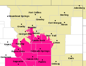
...Critical Fire Weather Conditions for the southern foothills,
South Park, and the Palmer Divide...
COZ214-216-241-150000-
/O.UPG.KBOU.FW.A.0020.220514T1700Z-220515T0200Z/
/O.NEW.KBOU.FW.W.0027.220514T1800Z-220515T0100Z/
Central and Southeast Park County-
Jefferson and West Douglas Counties Above 6000 Feet/Gilpin/Clear Creek/Northeast Park Counties Below 9000 Feet-
Elbert/Central and East Douglas Counties Above 6000 Feet-
221 AM MDT Sat May 14 2022
...
RED FLAG WARNING IN EFFECT FROM NOON TODAY TO 7 PM MDT THIS EVENING FOR WIND AND LOW RELATIVE HUMIDITY FOR FIRE WEATHER ZONES 214, 216, AND 241.
The National Weather Service in Denver has issued a Red Flag Warning for wind and low relative humidity, which is in effect from noon today to 7 PM MDT this evening. The Fire Weather Watch is no longer in effect.
* Affected Area...Fire Weather Zones 214, 216 and 241.
* Timing...Red Flag Warning starting 12 PM this afternoon to 7 PM this evening.
* Winds...West 10 to 20 mph with gusts up to 35 mph.
* Relative Humidity...As low as 11 percent.
* Impacts...Any fire that starts will have the potential to spread rapidly. Avoid burning or any outdoor activity that may produce a spark and start a wildfire.
PRECAUTIONARY/PREPAREDNESS ACTIONS...
A Red Flag Warning means that critical fire weather conditions are either occurring now....or will shortly. A combination of strong winds...low relative humidity...and warm temperatures can contribute to extreme fire behavior.