- Posts: 9766
- Thank you received: 221
- Forum
- Life Up the Hill
- Scanner & Emergency Info, Weather Forecasts
- Red Flag Warning Thursday May 18; Winter Storm Watch Friday 5/19
Red Flag Warning Thursday May 18; Winter Storm Watch Friday 5/19
- MountainTownAlerts
-
 Topic Author
- Mountain Legend
-

Less
More
18 May 2022 08:10 #1
by MountainTownAlerts
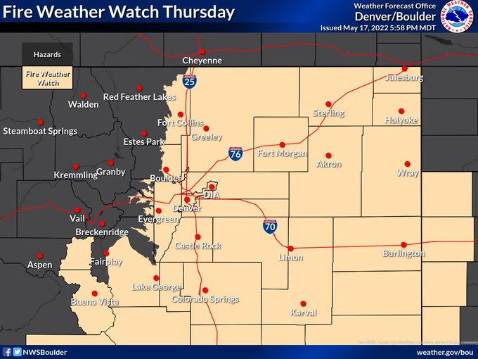
Fire Weather Watch
URGENT - FIRE WEATHER MESSAGE
National Weather Service Denver/Boulder CO
510 AM MDT Wed May 18 2022
COZ214-216-238>251-182100-
/O.CON.KBOU.FW.A.0021.220519T1700Z-220520T0200Z/
Central and Southeast Park County-
Jefferson and West Douglas Counties Above 6000 Feet/Gilpin/Clear Creek/Northeast Park Counties Below 9000 Feet-
Larimer County Below 6000 Feet/Northwest Weld County-
Boulder And Jefferson Counties Below 6000 Feet/West Broomfield County-
North Douglas County Below 6000 Feet/Denver/West Adams and
Arapahoe Counties/East Broomfield County-
Elbert/Central and East Douglas Counties Above 6000 Feet-
Northeast Weld County-Central and South Weld County-Morgan County-
Central and East Adams and Arapahoe Counties-
North and Northeast Elbert County Below 6000 Feet/North Lincoln County-
Southeast Elbert County Below 6000 Feet/South Lincoln County-
Logan County-Washington County-Sedgwick County-Phillips County-
510 AM MDT Wed May 18 2022
...FIRE WEATHER WATCH REMAINS IN EFFECT FROM THURSDAY MORNING THROUGH THURSDAY EVENING FOR WIND AND LOW RELATIVE HUMIDITY FOR SOUTH PARK...SOUTHERN FRONT RANGE FOOTHILLS...AND ALL OF THE NORTHEAST PLAINS OF COLORADO...
* Affected Area...Fire Weather Zones 214, 216, 238, 239, 240, 241, 242, 243, 244, 245, 246, 247, 248, 249, 250 and 251.
* Timing...Thursday afternoon through Thursday evening.
* Winds...West 15 to 25 mph with gusts up to 40 mph.
* Relative Humidity...10 to 15 percent.
* Impacts...Any fire that starts will have the potential to spread rapidly. Avoid burning or any outdoor activity that may produce a spark and start a wildfire.
PRECAUTIONARY/PREPAREDNESS ACTIONS...
A Fire Weather Watch means that critical fire weather conditions are forecast to occur. Listen for later forecasts and possible Red Flag Warnings.
Winter Storm Watch
URGENT - WINTER WEATHER MESSAGE
National Weather Service Denver CO
409 AM MDT Wed May 18 2022
...LATE SPRING STORM MAY BRING HEAVY SNOW TO THE FRONT RANGE MOUNTAINS AND FOOTHILLS THIS FRIDAY AND SATURDAY...
.Confidence is increasing in moderate to heavy snowfall in the Front Range mountains and foothills, mostly above 7000 feet and primarily along the eastern slopes, late Thursday through Saturday morning. There is still a lot of uncertainty in snowfall totals but significant impacts seem likely, especially to mountain travel.
COZ034-036-182100-
/O.NEW.KBOU.WS.A.0006.220520T1800Z-220521T1800Z/
South and Southeast Grand/West Central and Southwest Boulder/Gilpin/Clear Creek/Summit/North and West Park Counties Above 9000 Feet-Jefferson and West Douglas Counties Above 6000 Feet/Gilpin/Clear Creek/Northeast Park Counties Below 9000 Feet-
Including the cities of Evergreen, Georgetown, Indian Peaks, Idaho Springs, Eisenhower Tunnel, East Slopes Southern Gore Range, Mount Evans, Central City, East Slopes Mosquito Range, Breckenridge, Winter Park, Williams Fork Mountains, Bailey, Kenosha Mountains, Westcreek, and Berthoud Pass
409 AM MDT Wed May 18 2022
...WINTER STORM WATCH IN EFFECT FROM FRIDAY AFTERNOON THROUGH SATURDAY MORNING...
* WHAT...Heavy snow possible. Total snow accumulations generally between 4 and 12 inches with locally higher amounts possible.
* WHERE...The Mountains of Summit County, the Mosquito Range, and the Indian Peaks, and The Southern Front Range Foothills.
* WHEN...From Friday afternoon through Saturday morning.
* IMPACTS...Roads will likely become slick and hazardous. Snow covered roads will make travel hazardous. Travel may become very difficult to impossible due to heavy snowfall on roadways. Travel could be very difficult to impossible. The hazardous conditions could impact the Friday evening commute.
PRECAUTIONARY/PREPAREDNESS ACTIONS...
Monitor the latest forecasts for updates on this situation.
Persons should consider delaying all travel. Motorists should use extreme caution if travel is absolutely necessary.
Roads will be slick resulting in slow and hazardous travel. Allow extra time to reach your destination.
Please Log in or Create an account to join the conversation.
- MountainTownAlerts
-
Topic Author
- Mountain Legend
-
Less
More
- Posts: 9766
- Thank you received: 221
18 May 2022 17:55 #2
by MountainTownAlerts
Red Flag Warning
URGENT - FIRE WEATHER MESSAGE
National Weather Service Denver/Boulder CO
216 PM MDT Wed May 18 2022
...CRITICAL FIRE WEATHER CONDITIONS THURSDAY FOR SOUTHERN FOOTHILLS, SOUTH PARK, PALMER DIVIDE, URBAN CORRIDOR, AND EASTERN PLAINS FOR FIRE WEATHER ZONES 214, 216, 238, 239, 240, 241, 242, 243, 244, 245, 246, 247, 248, 249, 250, AND 251......
COZ214-216-238>251-191800-
/O.UPG.KBOU.FW.A.0021.220519T1700Z-220520T0200Z/
/O.NEW.KBOU.FW.W.0028.220519T1700Z-220520T0200Z/
Central and Southeast Park County-
Jefferson and West Douglas Counties Above 6000 Feet/Gilpin/Clear
Creek/Northeast Park Counties Below 9000 Feet-
Larimer County Below 6000 Feet/Northwest Weld County-
Boulder And Jefferson Counties Below 6000 Feet/West Broomfield County-
North Douglas County Below 6000 Feet/Denver/West Adams and Arapahoe Counties/East Broomfield County-
Elbert/Central and East Douglas Counties Above 6000 Feet-
Northeast Weld County-Central and South Weld County-Morgan County-
Central and East Adams and Arapahoe Counties-
North and Northeast Elbert County Below 6000 Feet/North Lincoln County-
Southeast Elbert County Below 6000 Feet/South Lincoln County-
Logan County-Washington County-Sedgwick County-Phillips County-
216 PM MDT Wed May 18 2022
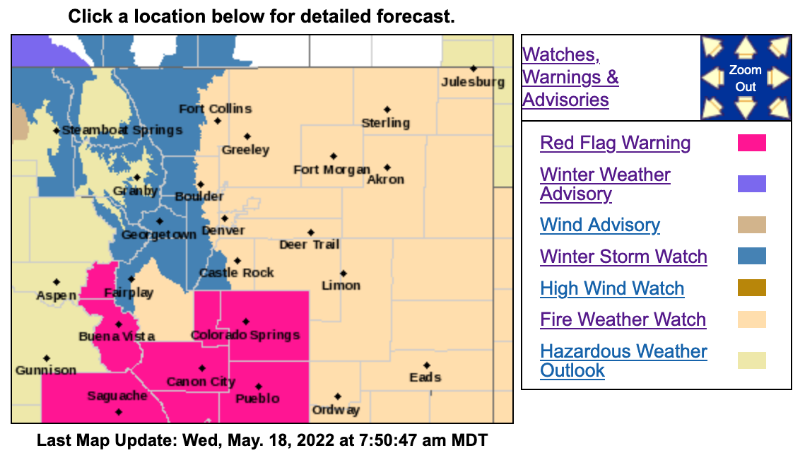
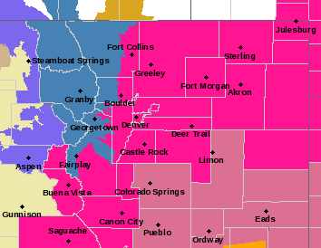
...RED FLAG WARNING IN EFFECT FROM 11 AM TO 8 PM MDT THURSDAY FOR WIND AND LOW RELATIVE HUMIDITY FOR FIRE WEATHER ZONES 214, 216, 238, 239, 240, 241, 242, 243, 244, 245, 246, 247, 248, 249, 250, AND 251...
The National Weather Service in Denver has issued a Red Flag Warning for wind and low relative humidity, which is in effect from 11 AM to 8 PM MDT Thursday. The Fire Weather Watch is no longer in effect.
* Affected Area...Fire Weather Zones 214, 216, 238, 239, 240, 241, 242, 243, 244, 245, 246, 247, 248, 249, 250 and 251.
* Timing...Thursday 11 AM through Thursday 8 PM. Parts of the foothills and South Park could begin earlier due to strong downslope winds. Conditions will quickly improve late Thursday evening as incoming moisture arrives.
* Winds...West 15 to 25 mph with gusts up to 40 mph.
* Relative Humidity...As low as 12 percent.
* Impacts...Any fire that starts will have the potential to spread rapidly. Avoid burning or any outdoor activity that may produce a spark and start a wildfire.
PRECAUTIONARY/PREPAREDNESS ACTIONS...
A Red Flag Warning means that critical fire weather conditions are either occurring now....or will shortly. A combination of strong winds...low relative humidity...and warm temperatures can contribute to extreme fire behavior.
Replied by MountainTownAlerts on topic Red Flag Warning Thursday May 18; Winter Storm Watch Friday 5/19
Red Flag Warning
URGENT - FIRE WEATHER MESSAGE
National Weather Service Denver/Boulder CO
216 PM MDT Wed May 18 2022
...CRITICAL FIRE WEATHER CONDITIONS THURSDAY FOR SOUTHERN FOOTHILLS, SOUTH PARK, PALMER DIVIDE, URBAN CORRIDOR, AND EASTERN PLAINS FOR FIRE WEATHER ZONES 214, 216, 238, 239, 240, 241, 242, 243, 244, 245, 246, 247, 248, 249, 250, AND 251......
COZ214-216-238>251-191800-
/O.UPG.KBOU.FW.A.0021.220519T1700Z-220520T0200Z/
/O.NEW.KBOU.FW.W.0028.220519T1700Z-220520T0200Z/
Central and Southeast Park County-
Jefferson and West Douglas Counties Above 6000 Feet/Gilpin/Clear
Creek/Northeast Park Counties Below 9000 Feet-
Larimer County Below 6000 Feet/Northwest Weld County-
Boulder And Jefferson Counties Below 6000 Feet/West Broomfield County-
North Douglas County Below 6000 Feet/Denver/West Adams and Arapahoe Counties/East Broomfield County-
Elbert/Central and East Douglas Counties Above 6000 Feet-
Northeast Weld County-Central and South Weld County-Morgan County-
Central and East Adams and Arapahoe Counties-
North and Northeast Elbert County Below 6000 Feet/North Lincoln County-
Southeast Elbert County Below 6000 Feet/South Lincoln County-
Logan County-Washington County-Sedgwick County-Phillips County-
216 PM MDT Wed May 18 2022
...RED FLAG WARNING IN EFFECT FROM 11 AM TO 8 PM MDT THURSDAY FOR WIND AND LOW RELATIVE HUMIDITY FOR FIRE WEATHER ZONES 214, 216, 238, 239, 240, 241, 242, 243, 244, 245, 246, 247, 248, 249, 250, AND 251...
The National Weather Service in Denver has issued a Red Flag Warning for wind and low relative humidity, which is in effect from 11 AM to 8 PM MDT Thursday. The Fire Weather Watch is no longer in effect.
* Affected Area...Fire Weather Zones 214, 216, 238, 239, 240, 241, 242, 243, 244, 245, 246, 247, 248, 249, 250 and 251.
* Timing...Thursday 11 AM through Thursday 8 PM. Parts of the foothills and South Park could begin earlier due to strong downslope winds. Conditions will quickly improve late Thursday evening as incoming moisture arrives.
* Winds...West 15 to 25 mph with gusts up to 40 mph.
* Relative Humidity...As low as 12 percent.
* Impacts...Any fire that starts will have the potential to spread rapidly. Avoid burning or any outdoor activity that may produce a spark and start a wildfire.
PRECAUTIONARY/PREPAREDNESS ACTIONS...
A Red Flag Warning means that critical fire weather conditions are either occurring now....or will shortly. A combination of strong winds...low relative humidity...and warm temperatures can contribute to extreme fire behavior.
Please Log in or Create an account to join the conversation.
- Forum
- Life Up the Hill
- Scanner & Emergency Info, Weather Forecasts
- Red Flag Warning Thursday May 18; Winter Storm Watch Friday 5/19
Time to create page: 0.180 seconds
sponsors


