- Posts: 9766
- Thank you received: 221
- Forum
- Life Up the Hill
- Scanner & Emergency Info, Weather Forecasts
- Winter Storm Warning May 20-21, 2022
Winter Storm Warning May 20-21, 2022
- MountainTownAlerts
-
 Topic Author
- Mountain Legend
-

Less
More
19 May 2022 18:12 #1
by MountainTownAlerts
Winter Storm Warning May 20-21, 2022 was created by MountainTownAlerts
URGENT: My Mountain Town Weather from Chief Meteorologist Steve Hamilton:
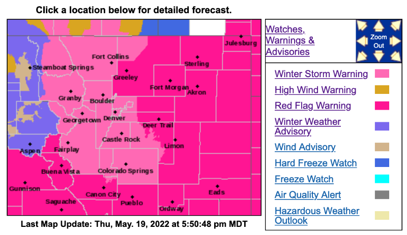
The National Weather Service in Boulder has issued a WINTER STORM WARNING from Noon Friday to Noon Saturday.
Most Foothills locations are included.
-Heavy snow is expected. Totals: 12 to 24 inches possible.
-Heavy snow will accumulate on tree branches and power lines, possibly causing them to break and lead to power outages. Travel may become very difficult to impossible due to heavy snowfall on roadways.
*We'll post snow total estimates per location this evening here: mymountaintown.com/expert-local-weather
Winter Storm Warning
URGENT - WINTER WEATHER MESSAGE
National Weather Service Denver CO
235 PM MDT Thu May 19 2022
...LATE SPRING STORM TO BRING HEAVY SNOW TO THE MOUNTAINS, FOOTHILLS, AND FRONT RANGE URBAN CORRIDOR FRIDAY THROUGH SATURDAY MORNING...
.Heavy snow will develop tonight over the northern mountains and foothills. Snow will spread south and east through the day Friday. The heaviest accumulating snow for the Denver Metro area is expected to begin late Friday afternoon or evening and then continue into Saturday morning. The heavy snow will accumulate on trees and powerlines, causing some to break. Do not park under trees and avoid walking under snow covered trees. Numerous tree branches are expected to break and may lead to power outages.
COZ037-200845-
/O.CON.KBOU.WS.W.0007.220520T1800Z-220521T1800Z/
Central and Southeast Park County-
Including the cities of Fairplay, South Park, Hartsel, and Lake George
235 PM MDT Thu May 19 2022
...WINTER STORM WARNING REMAINS IN EFFECT FROM NOON FRIDAY TO NOON MDT SATURDAY...
* WHAT...Heavy snow expected. Total snow accumulations between 6 and 12 inches.
* WHERE...South Park.
* WHEN...From Noon Friday to Noon MDT Saturday.
* IMPACTS...Heavy snow will accumulate on tree branches and powerlines, possibly causing them to break and lead to power outages. Travel may become very difficult due to heavy snowfall on roadways.
PRECAUTIONARY/PREPAREDNESS ACTIONS...
Do not touch downed powerlines and report any power outages to your electric company. Travel is highly discouraged due to slick roadways and the possibility of downed trees and power lines.
_ _ _ _ _ _ _ _ _ _ _ _ _ _ _ _ _ _ _ _ _ _ _ _
URGENT - WINTER WEATHER MESSAGE
National Weather Service Denver CO
235 PM MDT Thu May 19 2022
COZ038>040-200845-
/O.CON.KBOU.WS.W.0007.220520T1800Z-220521T1800Z/
Larimer County Below 6000 Feet/Northwest Weld County-Boulder And Jefferson Counties Below 6000 Feet/West Broomfield County-North Douglas County Below 6000 Feet/Denver/West Adams and Arapahoe Counties/East Broomfield County-
Including the cities of Boulder, Golden, Highlands Ranch, City of Denver, Lakewood, Fort Collins, Aurora, Arvada, Loveland, Littleton, Nunn, Longmont, Hereford, Parker, Denver International Airport, and Brighton
235 PM MDT Thu May 19 2022
...WINTER STORM WARNING REMAINS IN EFFECT FROM NOON FRIDAY TO NOON MDT SATURDAY...
* WHAT...Heavy snow expected. Total snow accumulations between 4 and 12 inches. Locally higher amounts near the foothills and Palmer Divide
* WHERE...Fort Collins, Boulder and the western suburbs of Denver, and Denver.
_ _ _ _ _ _ _ _ _ _ _ _ _ _ _ _ _ _ _ _ _ _ _ _
URGENT - WINTER WEATHER MESSAGE
National Weather Service Denver CO
235 PM MDT Thu May 19 2022
COZ034-036-200845-
/O.CON.KBOU.WS.W.0007.220520T1800Z-220521T1800Z/
South and Southeast Grand/West Central and Southwest Boulder/Gilpin/Clear Creek/Summit/North and West Park Counties Above 9000 Feet-Jefferson and West Douglas Counties Above 6000 Feet/Gilpin/Clear Creek/Northeast Park Counties Below 9000 Feet-
Including the cities of Evergreen, Georgetown, Indian Peaks, Idaho Springs, Eisenhower Tunnel, East Slopes Southern Gore Range, Mount Evans, Central City, East Slopes Mosquito Range, Breckenridge, Winter Park, Williams Fork Mountains, Bailey, Kenosha Mountains, Westcreek, and Berthoud Pass
235 PM MDT Thu May 19 2022
...WINTER STORM WARNING REMAINS IN EFFECT FROM NOON FRIDAY TO NOON MDT SATURDAY...
* WHAT...Heavy snow expected. Total snow accumulations between 12 and 24 inches.
* WHERE...The Mountains of Summit County, the Mosquito Range, and the Indian Peaks, and The Southern Front Range Foothills.
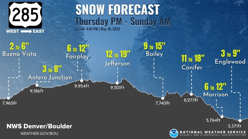
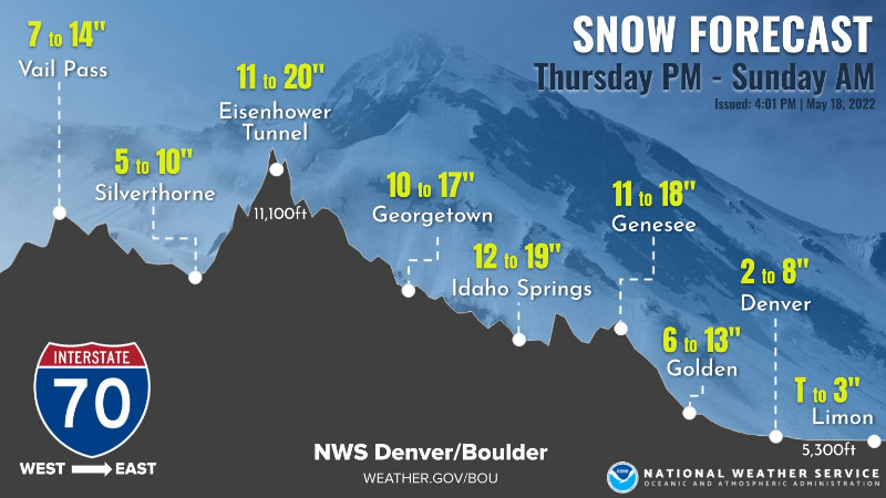
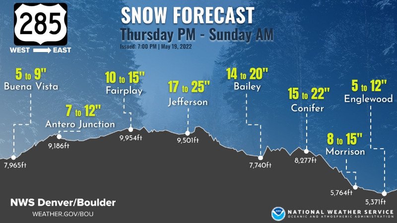
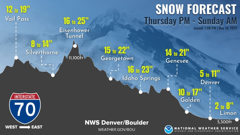
NWS Highway 285 and I-70 Maps with elevations and predicted snow amounts:
The National Weather Service in Boulder has issued a WINTER STORM WARNING from Noon Friday to Noon Saturday.
Most Foothills locations are included.
-Heavy snow is expected. Totals: 12 to 24 inches possible.
-Heavy snow will accumulate on tree branches and power lines, possibly causing them to break and lead to power outages. Travel may become very difficult to impossible due to heavy snowfall on roadways.
*We'll post snow total estimates per location this evening here: mymountaintown.com/expert-local-weather
Winter Storm Warning
URGENT - WINTER WEATHER MESSAGE
National Weather Service Denver CO
235 PM MDT Thu May 19 2022
...LATE SPRING STORM TO BRING HEAVY SNOW TO THE MOUNTAINS, FOOTHILLS, AND FRONT RANGE URBAN CORRIDOR FRIDAY THROUGH SATURDAY MORNING...
.Heavy snow will develop tonight over the northern mountains and foothills. Snow will spread south and east through the day Friday. The heaviest accumulating snow for the Denver Metro area is expected to begin late Friday afternoon or evening and then continue into Saturday morning. The heavy snow will accumulate on trees and powerlines, causing some to break. Do not park under trees and avoid walking under snow covered trees. Numerous tree branches are expected to break and may lead to power outages.
COZ037-200845-
/O.CON.KBOU.WS.W.0007.220520T1800Z-220521T1800Z/
Central and Southeast Park County-
Including the cities of Fairplay, South Park, Hartsel, and Lake George
235 PM MDT Thu May 19 2022
...WINTER STORM WARNING REMAINS IN EFFECT FROM NOON FRIDAY TO NOON MDT SATURDAY...
* WHAT...Heavy snow expected. Total snow accumulations between 6 and 12 inches.
* WHERE...South Park.
* WHEN...From Noon Friday to Noon MDT Saturday.
* IMPACTS...Heavy snow will accumulate on tree branches and powerlines, possibly causing them to break and lead to power outages. Travel may become very difficult due to heavy snowfall on roadways.
PRECAUTIONARY/PREPAREDNESS ACTIONS...
Do not touch downed powerlines and report any power outages to your electric company. Travel is highly discouraged due to slick roadways and the possibility of downed trees and power lines.
_ _ _ _ _ _ _ _ _ _ _ _ _ _ _ _ _ _ _ _ _ _ _ _
URGENT - WINTER WEATHER MESSAGE
National Weather Service Denver CO
235 PM MDT Thu May 19 2022
COZ038>040-200845-
/O.CON.KBOU.WS.W.0007.220520T1800Z-220521T1800Z/
Larimer County Below 6000 Feet/Northwest Weld County-Boulder And Jefferson Counties Below 6000 Feet/West Broomfield County-North Douglas County Below 6000 Feet/Denver/West Adams and Arapahoe Counties/East Broomfield County-
Including the cities of Boulder, Golden, Highlands Ranch, City of Denver, Lakewood, Fort Collins, Aurora, Arvada, Loveland, Littleton, Nunn, Longmont, Hereford, Parker, Denver International Airport, and Brighton
235 PM MDT Thu May 19 2022
...WINTER STORM WARNING REMAINS IN EFFECT FROM NOON FRIDAY TO NOON MDT SATURDAY...
* WHAT...Heavy snow expected. Total snow accumulations between 4 and 12 inches. Locally higher amounts near the foothills and Palmer Divide
* WHERE...Fort Collins, Boulder and the western suburbs of Denver, and Denver.
_ _ _ _ _ _ _ _ _ _ _ _ _ _ _ _ _ _ _ _ _ _ _ _
URGENT - WINTER WEATHER MESSAGE
National Weather Service Denver CO
235 PM MDT Thu May 19 2022
COZ034-036-200845-
/O.CON.KBOU.WS.W.0007.220520T1800Z-220521T1800Z/
South and Southeast Grand/West Central and Southwest Boulder/Gilpin/Clear Creek/Summit/North and West Park Counties Above 9000 Feet-Jefferson and West Douglas Counties Above 6000 Feet/Gilpin/Clear Creek/Northeast Park Counties Below 9000 Feet-
Including the cities of Evergreen, Georgetown, Indian Peaks, Idaho Springs, Eisenhower Tunnel, East Slopes Southern Gore Range, Mount Evans, Central City, East Slopes Mosquito Range, Breckenridge, Winter Park, Williams Fork Mountains, Bailey, Kenosha Mountains, Westcreek, and Berthoud Pass
235 PM MDT Thu May 19 2022
...WINTER STORM WARNING REMAINS IN EFFECT FROM NOON FRIDAY TO NOON MDT SATURDAY...
* WHAT...Heavy snow expected. Total snow accumulations between 12 and 24 inches.
* WHERE...The Mountains of Summit County, the Mosquito Range, and the Indian Peaks, and The Southern Front Range Foothills.
NWS Highway 285 and I-70 Maps with elevations and predicted snow amounts:
Please Log in or Create an account to join the conversation.
- MountainTownAlerts
-
Topic Author
- Mountain Legend
-
Less
More
- Posts: 9766
- Thank you received: 221
20 May 2022 09:28 - 20 May 2022 09:31 #2
by MountainTownAlerts
Replied by MountainTownAlerts on topic Winter Storm Warning May 20-21, 2022
From NWS:
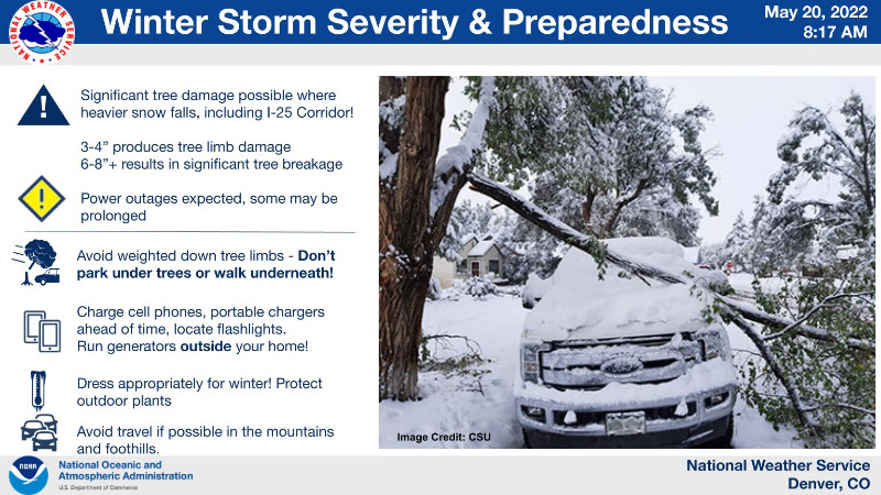
Winter Storm Impacts and Preparedness
With the heavy wet snow expected to accumulate, significant tree damage will be possible along with scattered power outages. Highest impacts with regard to trees is expected tonight.
Difficult travel for Front Range Mountains & Foothills starting today, Palmer Divide late this aft/eve. #COwx
Refresher: Preparing for Winter in the Mountains
Updated snow amounts along the highway elevations (maps of Hwy 285 and I-70):
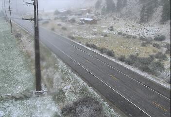
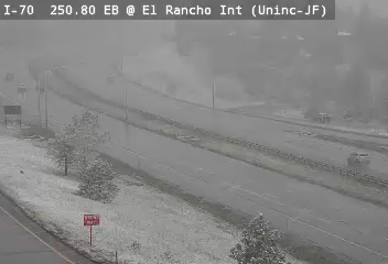
From @TujungaDude 1h
Snow begins at 9600’ behind Kenosha pass, at about 8am @NWSBoulder
@MyMountainTown
Webcam views of Hwy 285 north of CR-60 and on I-70 at El Rancho as of 9:25am
mymountaintown.com/weather-traffic
Winter Storm Impacts and Preparedness
With the heavy wet snow expected to accumulate, significant tree damage will be possible along with scattered power outages. Highest impacts with regard to trees is expected tonight.
Difficult travel for Front Range Mountains & Foothills starting today, Palmer Divide late this aft/eve. #COwx
Refresher: Preparing for Winter in the Mountains
Updated snow amounts along the highway elevations (maps of Hwy 285 and I-70):
From @TujungaDude 1h
Snow begins at 9600’ behind Kenosha pass, at about 8am @NWSBoulder
@MyMountainTown
Webcam views of Hwy 285 north of CR-60 and on I-70 at El Rancho as of 9:25am
mymountaintown.com/weather-traffic
Last edit: 20 May 2022 09:31 by MountainTownAlerts.
Please Log in or Create an account to join the conversation.
- Forum
- Life Up the Hill
- Scanner & Emergency Info, Weather Forecasts
- Winter Storm Warning May 20-21, 2022
Time to create page: 0.243 seconds
sponsors


