My Mountain Town Local Weather Forecast From Chief Meteorologist Steve Hamilton:
Latest Expected Snow Totals...
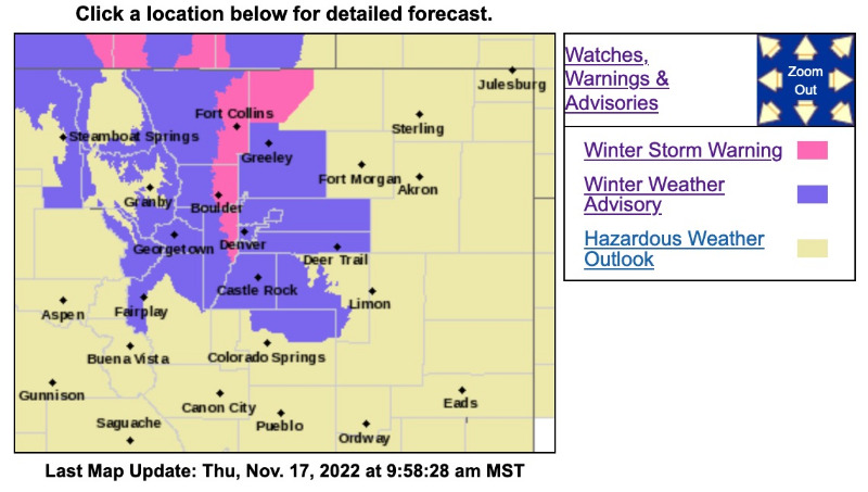
Due to heavy snow bands and enhanced upslope lifting, the National Weather Service has revised the snow totals map for the Foothills and the Denver Metro. This is what we can expect through today and into tonight. Let us know how much you're getting.
Check our webcams before you head out to see real-time road conditions:
mymountaintown.com/weather-traffic
Also, any passenger vehicle traction laws or commercial vehicle chain laws will be shared here:
Travel Alerts November 17, 2022
Winter Storm Warning
URGENT - WINTER WEATHER MESSAGE
National Weather Service Denver CO
834 AM MST Thu Nov 17 2022
COZ039-180215-
/O.UPG.KBOU.WW.Y.0033.221117T1900Z-221118T1600Z/
/O.NEW.KBOU.WS.W.0009.221117T1534Z-221118T1600Z/
Boulder And Jefferson Counties Below 6000 Feet/West Broomfield County-
Including the cities of Longmont, Arvada, Golden, Boulder, and Lakewood
834 AM MST Thu Nov 17 2022
...
WINTER STORM WARNING IN EFFECT UNTIL 9 AM MST FRIDAY...
* WHAT...
Heavy snow ongoing. Additional snow accumulations between 5 and 10 inches.
* WHERE...Boulder and the western suburbs of Denver.
* WHEN...Until 9 AM MST Friday.
* IMPACTS...Travel could be very difficult. The hazardous conditions could impact the Thursday morning and evening commutes.
PRECAUTIONARY/PREPAREDNESS ACTIONS...
If you must travel, keep an extra flashlight, food, and water in your vehicle in case of an emergency. The latest road conditions for Colorado can be obtained by calling 5 1 1 or by going to
www.cotrip.org
.
_ _ _ _ _ _ _ _ _ _ _ _ _ _ _ _ _ _ _ _ _ _ _ _ _ _ _ _ _ _
URGENT - WINTER WEATHER MESSAGE
National Weather Service Denver CO
834 AM MST Thu Nov 17 2022
Winter Weather Advisory
COZ036-040-041-045-180215-
/O.EXT.KBOU.WW.Y.0033.221117T1534Z-221118T1600Z/
Jefferson and West Douglas Counties Above 6000 Feet/Gilpin/Clear Creek/Northeast Park Counties Below 9000 Feet-
North Douglas County Below 6000 Feet/Denver/West Adams and Arapahoe Counties/East Broomfield County-Elbert/Central and East Douglas Counties Above 6000 Feet-Central and East Adams and Arapahoe Counties-
Including the cities of City of Denver, Fondis,
Idaho Springs, Deer Trail, Brighton,
Georgetown, Westcreek, Leader, Kiowa, Central City, Byers, Bennett,
Littleton, Evergreen, Denver International Airport, Castle Rock,
Bailey, Elbert, Highlands Ranch, Aurora, Parker, and Larkspur
834 AM MST Thu Nov 17 2022
...
WINTER WEATHER ADVISORY NOW IN EFFECT UNTIL 9 AM MST FRIDAY...
* WHAT...
Snow ongoing. Total snow accumulations between 2 and 6 inches. Locally higher amounts possible.
* WHERE...The Southern Front Range Foothills, Denver, Castle Rock, and Byers.
* WHEN...Until 9 AM MST Friday.
* IMPACTS...Travel could be very difficult. The hazardous conditions could impact the Thursday morning and evening commutes.
South and Southeast Grand/West Central and Southwest Boulder/Gilpin/
Clear Creek/Summit/North and West Park Counties Above 9000 Feet-
Including the cities of Berthoud Pass, Williams Fork Mountains, Breckenridge, Mount Evans, Eisenhower Tunnel, Winter Park, East Slopes Southern Gore Range, Kenosha Mountains, Indian Peaks, and East Slopes Mosquito Range
834 AM MST Thu Nov 17 2022
...
WINTER WEATHER ADVISORY REMAINS IN EFFECT FROM NOON TODAY TO 9 AM MST FRIDAY...
* WHAT...
Snow ongoing. Total snow accumulations between 3 and 8 inches, with lower amounts in Summit and Park Counties. Winds gusting as high as 40 mph.
* WHERE...The Mountains of Summit County, the Mosquito Range, and the Indian Peaks.
* WHEN...From Noon today to 9 AM MST Friday. Snow will become more widespread tonight.
* IMPACTS...Travel will be hazardous with slick and snowpacked roads.
PRECAUTIONARY/PREPAREDNESS ACTIONS...
Slow down and use caution while traveling. The latest road conditions for Colorado can be obtained by calling 5 1 1 or by going to
www.cotrip.org
.