Latest forecast from Chief Meteorologist Steve Hamilton:
A Cold Front And Low Means Snow...
Yet another cold front will move into Colorado from the Pacific Northwest on Monday night and Tuesday. In combination with a closed low forming over southeast Colorado, we'll stand a good chance of a few inches of snow for the Foothills. The initial effects of the front will be felt on Monday with very gusty wind for most of our area, especially in the wind-prone areas around Fairplay and Alma, but we'll be breezy to gusty throughout the Foothills all day, and temperatures will stay mild. The front arrives Monday afternoon, followed by colder temperatures, and scattered snow showers. They shouldn't amount to much at first, but we may see an inch or so of accumulation overnight Monday. Then, our low pressure system will form early Tuesday, and should be in a favorable position for terrain-generated snowfall for much of Tuesday. Amounts will vary, but generally 1 to 4" will be possible for the Foothills. Snow totals will be modest, because the low will not have time enough to tap into moist air from the Gulf. Tuesday will also be cold, with highs mostly in the 20s. The system quickly exits off to the east by Wednesday, with a return to fair weather and somewhat warmer temperatures. The low is expected to produce severe weather for the Southern Plains, Gulf Coast and up into the Midwestern states late Tuesday and Wednesday.
mymountaintown.com/expert-local-weather
From NWS Boulder @NWSBoulder 36m
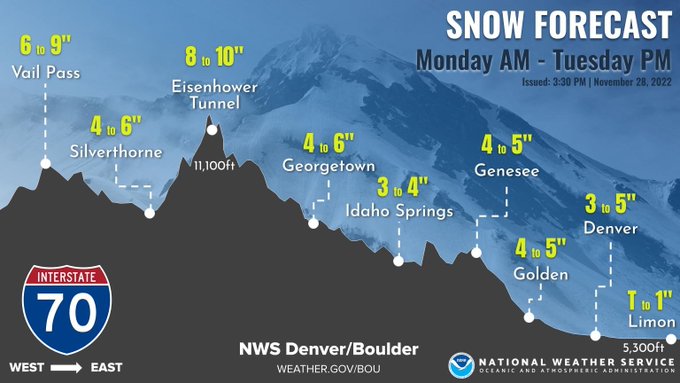
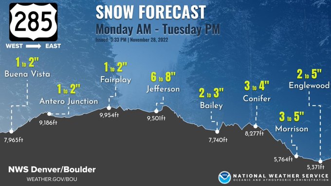
Here are the snow amounts forecasted for U.S. 36, U.S. 285, I-76, and CO-14. through Tuesday evening. Please take caution if traveling!
Winter Weather Advisory
URGENT - WINTER WEATHER MESSAGE
National Weather Service Denver CO
1219 PM MST Mon Nov 28 2022
COZ034-290515-
/O.CON.KBOU.WW.Y.0034.000000T0000Z-221130T0000Z/
South and Southeast Grand/West Central and Southwest Boulder/Gilpin/
Clear Creek/Summit/North and West Park Counties Above 9000 Feet-
Including the cities of Indian Peaks, Berthoud Pass, Winter Park, Eisenhower Tunnel, Mount Evans, East Slopes Southern Gore Range, Breckenridge, Kenosha Mountains, East Slopes Mosquito Range, and Williams Fork Mountains
1219 PM MST Mon Nov 28 2022
...
WINTER WEATHER ADVISORY REMAINS IN EFFECT UNTIL 5 PM MST TUESDAY...
* WHAT...Snow developing this afternoon.
Snow accumulations between 4 and 8 inches. Winds gusting as high as 45 mph.
* WHERE...The Mountains of Summit County, the Mosquito Range, and the Indian Peaks.
* WHEN...Until 5 PM MST Tuesday.
URGENT - WINTER WEATHER MESSAGE
National Weather Service Denver CO
1219 PM MST Mon Nov 28 2022
COZ036-039-040-290515-
/O.CON.KBOU.WW.Y.0034.221129T0900Z-221129T2100Z/
Jefferson and West Douglas Counties Above 6000 Feet/Gilpin/Clear Creek/Northeast Park Counties Below 9000 Feet-Boulder And Jefferson Counties Below 6000 Feet/West Broomfield County-North Douglas County Below 6000 Feet/Denver/West Adams and Arapahoe Counties/East Broomfield County-
Including the cities of Westcreek, Boulder, Littleton, Highlands Ranch, Parker,
Idaho Springs, Arvada, Georgetown, Golden, Longmont, Evergreen, Lakewood, Aurora, Central City, Brighton, City of Denver,
Denver International Airport, and Bailey
1219 PM MST Mon Nov 28 2022
...
WINTER WEATHER ADVISORY REMAINS IN EFFECT FROM 2 AM TO 2 PM MST TUESDAY...
* WHAT...Snow expected later tonight and Tuesday. Total snow accumulations between 2 and 5 inches.
* WHERE...The Southern Front Range Foothills, Boulder and the western suburbs of Denver, and Denver.
* WHEN...From 2 AM to 2 PM MST Tuesday.
* IMPACTS...Roads will likely become slick and hazardous. Plan on slippery road conditions. The hazardous conditions could impact the Tuesday morning commute.
PRECAUTIONARY/PREPAREDNESS ACTIONS...
Slow down and use caution while traveling. The latest road conditions for Colorado can be obtained by calling 5 1 1 or by going to
www.cotrip.org
.
Roads will be slick resulting in slow and hazardous travel. Allow extra time to reach your destination.
For more information from the National Weather Service, visit
weather.gov/bou