From Chief Meteorologist Steve Hamilton:
Some Snow... Strong Wind...
Another powerful cold front is on the way to Colorado from the Pacific Northwest. We'll start feeling the effects on Wednesday, with the wind picking up a bit, gusting over 30 mph for most of the Foothills. We may get some scattered snow showers on Friday, with very windy conditions. Gusts of 50 to 75 mph will be possible, especially in the more wind-prone areas. As for snow, we'll get most of it in the Fairplay, Alma, Como and Jefferson areas, where 4 to 8 inches will be possible, along with very gusty wind and cold temperatures, with winter storm conditions likely. For the rest of the Foothills, accumulations should amount to no more than a few inches. Wind will be very gusty for all areas through Saturday, and staying breezy Sunday.
Details for each town here:
mymountaintown.com/expert-local-weather
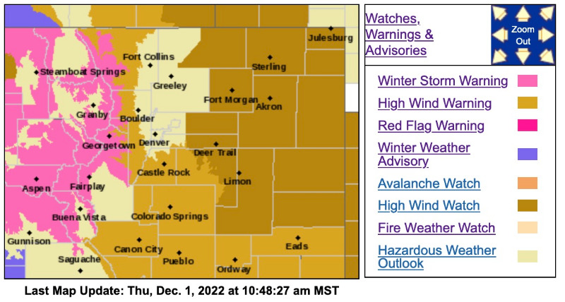
Winter Storm Warning
URGENT - WINTER WEATHER MESSAGE
National Weather Service Denver CO
244 AM MST Thu Dec 1 2022
COZ031-033-034-012200-
/O.UPG.KBOU.WS.A.0008.221202T0700Z-221203T0000Z/
/O.NEW.KBOU.WS.W.0011.221202T0700Z-221203T0000Z/
West Jackson and West Grand Counties Above 9000 Feet-South and East Jackson/Larimer/North and Northeast Grand/Northwest Boulder Counties Above 9000 Feet-South and Southeast Grand/West Central and Southwest Boulder/Gilpin/
Clear Creek/Summit/North and West Park Counties Above 9000 Feet-
Including the cities of Cameron Pass, Rocky Mountain National Park, Indian Peaks, Willow Creek Pass, Mt Zirkel, Berthoud Pass, East Slopes Mosquito Range, Eisenhower Tunnel, Mount Evans, Winter Park, Rabbit Ears Range, Breckenridge, Williams Fork Mountains, Kenosha Mountains, Laramie and Medicine Bow Mountains, and East Slopes Southern Gore Range
244 AM MST Thu Dec 1 2022
...
WINTER STORM WARNING IN EFFECT FROM MIDNIGHT TONIGHT TO 5 PM MST FRIDAY...
* WHAT...
Moderate to heavy snow expected and whiteout conditions possible. Total snow accumulations 5 to 10 inches possible. Winds could gust as high as 75 mph above timberline.
* WHERE...Rabbit Ears Pass, Rocky Mountain National Park and the Medicine Bow Range, and The Mountains of Summit County, the Mosquito Range, and the Indian Peaks.
* WHEN...From Midnight tonight to 5 PM MST Friday.
* IMPACTS...
Visibilities may drop below 1/4 mile due to falling and blowing snow. Travel may be quite difficult during the day Friday.
PRECAUTIONARY/PREPAREDNESS ACTIONS...
Monitor the latest forecasts for updates on this situation.
Persons should avoid travel in the mountains late Thursday night and Friday. If travel is absolutely necessary, be prepared for sudden changes in visibility. Leave plenty of room between you and the motorist ahead of you, and allow extra time to reach your destination. Make sure your car is winterized and in good working order.
For more information from the National Weather Service, visit
weather.gov/bou
_ _ _ _ _ _ _ _ _ _ _ _ _ _ _ _ _ _ _ _ _ _ _ _ _ _ _ _ _ _ _ _ _ _ _ _ _ _ _ _ _ _
High Wind Warning
URGENT - WEATHER MESSAGE
National Weather Service Denver CO
236 AM MST Thu Dec 1 2022
COZ035-036-020315-
/O.UPG.KBOU.HW.A.0008.221202T0300Z-221203T0000Z/
/O.NEW.KBOU.HW.W.0016.221202T0300Z-221203T0000Z/
Larimer and Boulder Counties Between 6000 and 9000 Feet-
Jefferson and West Douglas Counties Above 6000 Feet/Gilpin/Clear Creek/Northeast Park Counties Below 9000 Feet-
Including the cities of Central City, Georgetown, Evergreen, Nederland, Estes Park,
Bailey, Westcreek, Glendevey,
Idaho Springs, and Red Feather Lakes
236 AM MST Thu Dec 1 2022
...
HIGH WIND WARNING IN EFFECT FROM 8 PM THIS EVENING TO 5 PM MST FRIDAY...
* WHAT...
West winds 30 to 40 mph with gusts up to 75 mph.
* WHERE...The Front Range Foothills.
* WHEN...From 8 PM this evening to 5 PM MST Friday.
* IMPACTS...Gusty winds will blow around unsecured objects and scattered power outages may result. Travel will be difficult, especially for high profile vehicles.
PRECAUTIONARY/PREPAREDNESS ACTIONS...
Remain in the lower levels of your home during the windstorm, and avoid windows. Watch for falling debris and tree limbs. Use caution if you must drive.
Winds this strong can make driving difficult, especially for high profile vehicles. Use extra caution.