- Posts: 9766
- Thank you received: 221
- Forum
- Life Up the Hill
- Scanner & Emergency Info, Weather Forecasts
- Wind Chill & Red Flag Warnings, Winter Weather Advisory December 21-23, 2022
Wind Chill & Red Flag Warnings, Winter Weather Advisory December 21-23, 2022
- MountainTownAlerts
-
 Topic Author
- Mountain Legend
-

Less
More
20 Dec 2022 11:49 #1
by MountainTownAlerts
Wind Chill & Red Flag Warnings, Winter Weather Advisory December 21-23, 2022 was created by MountainTownAlerts
From Chief Meteorologist Steve Hamilton:
mymountaintown.com/expert-local-weather
Prepare for Dangerous Cold and Wind Chill...
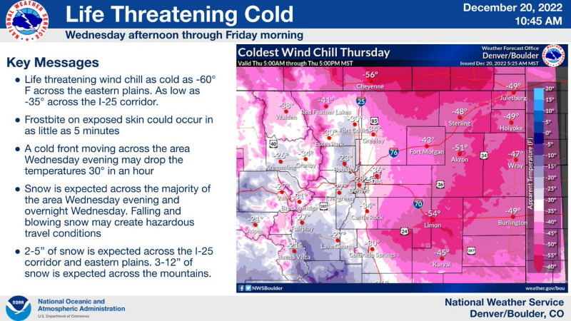
Tuesday and Wednesday will stay relatively mild with near-average daytime highs. Wind will get increasingly gusty, especially Wednesday, as a mass of very cold Arctic air closes in on eastern Colorado. By late Wednesday, we'll start to see a few snow showers popping up in the afternoon and the wind will pick up, with gusts at 25 to 35 mph. The Arctic air rolls in late Wednesday night into Thursday, with lows going well below zero for most of our area. Combined with the wind, it'll feel more like -35 to -50 occasionally. Thursday's highs will be near zero throughout the Foothills with extremely cold wind chills continuing. Again Thursday night, the lows will drop well below zero with dangerous wind chills. The wind will start calming down on Friday, and temperatures will begin to moderate, as the cold air mass moves east. Still cold, but not "as" cold for Christmas weekend.
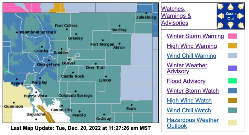
Wind Chill Watch
URGENT - WINTER WEATHER MESSAGE
National Weather Service Denver CO
352 AM MST Tue Dec 20 2022
COZ031-033-034-202200-
/O.NEW.KBOU.WS.A.0010.221221T1900Z-221222T1300Z/
/O.CON.KBOU.WC.A.0001.221222T0300Z-221223T1800Z/
West Jackson and West Grand Counties Above 9000 Feet-South and East Jackson/Larimer/North and Northeast Grand/Northwest Boulder Counties Above 9000 Feet-South and Southeast Grand/West Central and Southwest Boulder/Gilpin/Clear Creek/Summit/North and West Park Counties Above 9000 Feet-
Including the cities of Mt Zirkel, Berthoud Pass, Indian Peaks, Winter Park, Breckenridge, East Slopes Southern Gore Range, Rocky Mountain National Park, Willow Creek Pass, East Slopes Mosquito Range, Kenosha Mountains, Rabbit Ears Range, Cameron Pass, Mount Evans, Williams Fork Mountains, Eisenhower Tunnel, and Laramie and Medicine Bow Mountains
352 AM MST Tue Dec 20 2022
...WINTER STORM WATCH IN EFFECT FROM WEDNESDAY AFTERNOON THROUGH LATE WEDNESDAY NIGHT...
...WIND CHILL WATCH REMAINS IN EFFECT FROM WEDNESDAY EVENING THROUGH FRIDAY MORNING...
* WHAT...Heavy snow possible, accumulations between 3 and 12 inches with gust as high as 55 mph, blowing snow. Dangerously cold wind chills possible as low as 50 below zero.
* WHERE...Rabbit Ears Range and Pass, Rocky Mountain National Park and the Medicine Bow Range, the mountains of Summit County, the Mosquito Range, the Indian Peaks, and the Park and Gore Ranges.
* WHEN...Greatest snowfall expected Wednesday afternoon through Wednesday night. Dangerous wind chill expected to persist late Wednesday through early Friday.
* IMPACTS...Travel could be very difficult. Widespread blowing snow could significantly reduce visibility. The hazardous conditions could impact the Wednesday evening and Thursday morning commutes. The dangerously cold wind chills could cause frostbite on exposed skin in as little as 5 minutes.
_ _ _ _ _ _ _ _ _ _ _ _ _ _ _ _ _ _ _ _ _ _ _ _ _ _ _ _ _ _ _ _ _ _ _
Winter Storm Watch and Wind Chill Watch
URGENT - WINTER WEATHER MESSAGE
National Weather Service Denver CO
352 AM MST Tue Dec 20 2022
COZ030-032-035>051-202200-
/O.CON.KBOU.WC.A.0001.221222T0300Z-221223T1800Z/
Jackson County Below 9000 Feet-Grand and Summit Counties Below 9000 Feet-
Larimer and Boulder Counties Between 6000 and 9000 Feet-
Jefferson and West Douglas Counties Above 6000 Feet/Gilpin/Clear Creek/Northeast Park Counties Below 9000 Feet-Central and Southeast Park County-
Larimer County Below 6000 Feet/Northwest Weld County-
Boulder And Jefferson Counties Below 6000 Feet/West Broomfield County-
North Douglas County Below 6000 Feet/Denver/West Adams and Arapahoe Counties/East Broomfield County-Elbert/Central and East Douglas Counties Above 6000 Feet-
Northeast Weld County-Central and South Weld County-Morgan County-
Central and East Adams and Arapahoe Counties-North and Northeast Elbert County Below 6000 Feet/North Lincoln County-Southeast Elbert County Below 6000 Feet/South Lincoln County-Logan County-Washington County-Sedgwick County-Phillips County-
Including the cities of Fort Morgan, Leader, Spicer, Lakewood, Fondis, Larkspur, Deer Trail, Matheson, Cope, Castle Rock, Amherst, Georgetown, Haxtun, Fairplay, Idaho Springs, Roggen, Littleton, Sedgwick, Briggsdale, Parker, Westcreek, Limon, Elbert, Hot Sulphur Springs, Sterling, Golden, Pawnee Buttes, Peetz, Lake George, Grover, Goodrich, Estes Park, Byers, Glendevey, Raymer, Loveland, Fort Lupton, Crook, Last Chance, North Park, Kremmling, Bailey, Stoneham, Boulder, Nederland, South Park, Ovid, Bennett, Arvada, Rand, City of Denver, Otis, Granby, Karval, Brighton, Fort Collins, Brush, Wiggins, Longmont, Holyoke, Fraser, Highlands Ranch, Kutch, Merino, Walden, Hartsel, Nunn, Dillon, Eaton, Forder, Hugo, Julesburg, Hereford, Akron, Agate, Grand Lake, Kiowa, Red Feather Lakes, Central City, Aurora, Gould, Denver International Airport, Punkin Center, Greeley, and Evergreen
352 AM MST Tue Dec 20 2022
...WIND CHILL WATCH REMAINS IN EFFECT FROM WEDNESDAY EVENING THROUGH FRIDAY MORNING...
* WHAT...Dangerously cold wind chills possible, as low as 55 below zero.
* WHERE...All of northeast and north central Colorado below 6000 feet, including the Denver metro area.
* WHEN...From Wednesday evening through Friday morning.
* IMPACTS...The dangerously cold wind chills could cause frostbite on exposed skin in as little as 5 minutes.
PRECAUTIONARY/PREPAREDNESS ACTIONS...
The combination of wind and cold temperatures will create dangerously cold wind chill. Avoid outside activities if possible. When outside, limit exposure time, take frequent warming breaks, and make sure you dress warmly in several layers of clothing, including a hat and mittens.
For more information from the National Weather Service, visit
weather.gov/bou
Prepare for Dangerous Cold and Wind Chill...
Tuesday and Wednesday will stay relatively mild with near-average daytime highs. Wind will get increasingly gusty, especially Wednesday, as a mass of very cold Arctic air closes in on eastern Colorado. By late Wednesday, we'll start to see a few snow showers popping up in the afternoon and the wind will pick up, with gusts at 25 to 35 mph. The Arctic air rolls in late Wednesday night into Thursday, with lows going well below zero for most of our area. Combined with the wind, it'll feel more like -35 to -50 occasionally. Thursday's highs will be near zero throughout the Foothills with extremely cold wind chills continuing. Again Thursday night, the lows will drop well below zero with dangerous wind chills. The wind will start calming down on Friday, and temperatures will begin to moderate, as the cold air mass moves east. Still cold, but not "as" cold for Christmas weekend.
Wind Chill Watch
URGENT - WINTER WEATHER MESSAGE
National Weather Service Denver CO
352 AM MST Tue Dec 20 2022
COZ031-033-034-202200-
/O.NEW.KBOU.WS.A.0010.221221T1900Z-221222T1300Z/
/O.CON.KBOU.WC.A.0001.221222T0300Z-221223T1800Z/
West Jackson and West Grand Counties Above 9000 Feet-South and East Jackson/Larimer/North and Northeast Grand/Northwest Boulder Counties Above 9000 Feet-South and Southeast Grand/West Central and Southwest Boulder/Gilpin/Clear Creek/Summit/North and West Park Counties Above 9000 Feet-
Including the cities of Mt Zirkel, Berthoud Pass, Indian Peaks, Winter Park, Breckenridge, East Slopes Southern Gore Range, Rocky Mountain National Park, Willow Creek Pass, East Slopes Mosquito Range, Kenosha Mountains, Rabbit Ears Range, Cameron Pass, Mount Evans, Williams Fork Mountains, Eisenhower Tunnel, and Laramie and Medicine Bow Mountains
352 AM MST Tue Dec 20 2022
...WINTER STORM WATCH IN EFFECT FROM WEDNESDAY AFTERNOON THROUGH LATE WEDNESDAY NIGHT...
...WIND CHILL WATCH REMAINS IN EFFECT FROM WEDNESDAY EVENING THROUGH FRIDAY MORNING...
* WHAT...Heavy snow possible, accumulations between 3 and 12 inches with gust as high as 55 mph, blowing snow. Dangerously cold wind chills possible as low as 50 below zero.
* WHERE...Rabbit Ears Range and Pass, Rocky Mountain National Park and the Medicine Bow Range, the mountains of Summit County, the Mosquito Range, the Indian Peaks, and the Park and Gore Ranges.
* WHEN...Greatest snowfall expected Wednesday afternoon through Wednesday night. Dangerous wind chill expected to persist late Wednesday through early Friday.
* IMPACTS...Travel could be very difficult. Widespread blowing snow could significantly reduce visibility. The hazardous conditions could impact the Wednesday evening and Thursday morning commutes. The dangerously cold wind chills could cause frostbite on exposed skin in as little as 5 minutes.
_ _ _ _ _ _ _ _ _ _ _ _ _ _ _ _ _ _ _ _ _ _ _ _ _ _ _ _ _ _ _ _ _ _ _
Winter Storm Watch and Wind Chill Watch
URGENT - WINTER WEATHER MESSAGE
National Weather Service Denver CO
352 AM MST Tue Dec 20 2022
COZ030-032-035>051-202200-
/O.CON.KBOU.WC.A.0001.221222T0300Z-221223T1800Z/
Jackson County Below 9000 Feet-Grand and Summit Counties Below 9000 Feet-
Larimer and Boulder Counties Between 6000 and 9000 Feet-
Jefferson and West Douglas Counties Above 6000 Feet/Gilpin/Clear Creek/Northeast Park Counties Below 9000 Feet-Central and Southeast Park County-
Larimer County Below 6000 Feet/Northwest Weld County-
Boulder And Jefferson Counties Below 6000 Feet/West Broomfield County-
North Douglas County Below 6000 Feet/Denver/West Adams and Arapahoe Counties/East Broomfield County-Elbert/Central and East Douglas Counties Above 6000 Feet-
Northeast Weld County-Central and South Weld County-Morgan County-
Central and East Adams and Arapahoe Counties-North and Northeast Elbert County Below 6000 Feet/North Lincoln County-Southeast Elbert County Below 6000 Feet/South Lincoln County-Logan County-Washington County-Sedgwick County-Phillips County-
Including the cities of Fort Morgan, Leader, Spicer, Lakewood, Fondis, Larkspur, Deer Trail, Matheson, Cope, Castle Rock, Amherst, Georgetown, Haxtun, Fairplay, Idaho Springs, Roggen, Littleton, Sedgwick, Briggsdale, Parker, Westcreek, Limon, Elbert, Hot Sulphur Springs, Sterling, Golden, Pawnee Buttes, Peetz, Lake George, Grover, Goodrich, Estes Park, Byers, Glendevey, Raymer, Loveland, Fort Lupton, Crook, Last Chance, North Park, Kremmling, Bailey, Stoneham, Boulder, Nederland, South Park, Ovid, Bennett, Arvada, Rand, City of Denver, Otis, Granby, Karval, Brighton, Fort Collins, Brush, Wiggins, Longmont, Holyoke, Fraser, Highlands Ranch, Kutch, Merino, Walden, Hartsel, Nunn, Dillon, Eaton, Forder, Hugo, Julesburg, Hereford, Akron, Agate, Grand Lake, Kiowa, Red Feather Lakes, Central City, Aurora, Gould, Denver International Airport, Punkin Center, Greeley, and Evergreen
352 AM MST Tue Dec 20 2022
...WIND CHILL WATCH REMAINS IN EFFECT FROM WEDNESDAY EVENING THROUGH FRIDAY MORNING...
* WHAT...Dangerously cold wind chills possible, as low as 55 below zero.
* WHERE...All of northeast and north central Colorado below 6000 feet, including the Denver metro area.
* WHEN...From Wednesday evening through Friday morning.
* IMPACTS...The dangerously cold wind chills could cause frostbite on exposed skin in as little as 5 minutes.
PRECAUTIONARY/PREPAREDNESS ACTIONS...
The combination of wind and cold temperatures will create dangerously cold wind chill. Avoid outside activities if possible. When outside, limit exposure time, take frequent warming breaks, and make sure you dress warmly in several layers of clothing, including a hat and mittens.
For more information from the National Weather Service, visit
weather.gov/bou
Please Log in or Create an account to join the conversation.
- MountainTownAlerts
-
Topic Author
- Mountain Legend
-
Less
More
- Posts: 9766
- Thank you received: 221
21 Dec 2022 11:20 #2
by MountainTownAlerts
Replied by MountainTownAlerts on topic Wind Chill & Red Flag Warnings, Winter Weather Advisory December 21-23, 2022
Wind Chill Watch upgraded to Warning, Red Flag Warning also in effect.
From MMT Chief Meteorologist Steve Hamilton:
Prepare for Snow, Cold and Dangerous Wind Chill...
** Winter Weather Advisory
** Wind Chill Warning
A Winter Weather Advisory is in effect from 4:00 PM Wednesday until 9 AM Thursday for snow and blowing snow
A Wind Chill Warning is in effect from 8:00 PM Wednesday until 11:00 AM Friday
Snowfall amounts of 3 to 8 inches will be possible in the Foothills along with wind gusts up to 45 mph causing blowing and drifting snow, and whiteout conditions.
Cold temperatures combined with wind will cause wind chills of -40° to -50°. These will be very hazardous conditions.
Avoid travel and outdoor activities if possible. Make sure pets have adequate shelter.
Details for your mountain town:https://mymountaintown.com/expert-local-weather
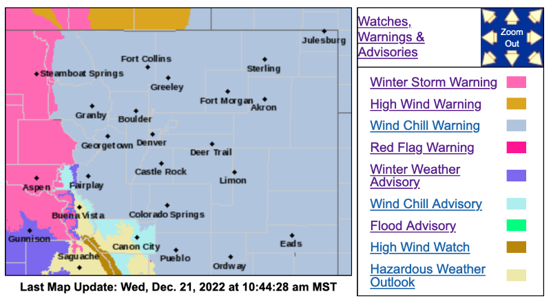
Red Flag Warning
URGENT - FIRE WEATHER MESSAGE
National Weather Service Denver/Boulder CO
515 AM MST Wed Dec 21 2022
COZ215-216-212300-
/O.CON.KBOU.FW.W.0044.221221T1800Z-221221T2300Z/
Larimer and Boulder Counties Between 6000 and 9000 Feet- Jefferson and West Douglas Counties Above 6000 Feet/Gilpin/Clear Creek/Northeast Park Counties Below 9000 Feet-
515 AM MST Wed Dec 21 2022
...RED FLAG WARNING REMAINS IN EFFECT FROM 11 AM THIS MORNING TO 4 PM MST THIS AFTERNOON FOR WIND AND LOW RELATIVE HUMIDITY FOR THE FRONT RANGE FOOTHILLS...FIRE WEATHER ZONES 215 AND 216...
* Affected Area...Fire Weather Zones 215 and 216.
* Timing...11 AM TO 4 PM today
* Winds...West 25 to 35 mph with gusts up to 60 mph.
* Relative Humidity...As low as 20 percent.
* Impacts...Strong winds, marginal relative humidity. Avoid any burning or outdoor activities that may produce a spark and start a fast moving wildfire.
PRECAUTIONARY/PREPAREDNESS ACTIONS...
A Red Flag Warning means that critical fire weather conditions are either occurring now....or will shortly. A combination of strong winds...low relative humidity...and warm temperatures can contribute to extreme fire behavior.
_ _ _ _ _ _ _ _ _ _ _ _ _ _ _ _ _ _ _ _ _ _ _ _ _ _ _ _ _ _
Wind Chill Warning
URGENT - WINTER WEATHER MESSAGE
National Weather Service Denver CO
1028 AM MST Wed Dec 21 2022
.A strong arctic airmass will bring well below normal temperatures to northeastern Colorado this evening through Friday. Strong winds will mean dangerous wind chill. The system will also bring snowfall this evening through Thursday morning across the mountains and plains. The greatest snowfall will be in the higher mountains. The best chance of moderate snowfall rates over the plains will be 6 to 9 PM Wednesday. A winter weather advisory has also been issued for the high mountain valleys of Jackson and Grand counties for later this afternoon and tonight.
COZ035-036-038>041-043-045>047-220530-
/O.CON.KBOU.WC.W.0001.221222T0300Z-221223T1800Z/
/O.CON.KBOU.WW.Y.0038.221221T2300Z-221222T1600Z/
Larimer and Boulder Counties Between 6000 and 9000 Feet-Jefferson and West Douglas Counties Above 6000 Feet/Gilpin/Clear Creek/Northeast Park Counties Below 9000 Feet-Larimer County Below 6000 Feet/Northwest Weld County-Boulder And Jefferson Counties Below 6000 Feet/West Broomfield County-North Douglas County Below 6000 Feet/Denver/West Adams and Arapahoe Counties/East Broomfield County-Elbert/Central and East Douglas Counties Above 6000 Feet-Central and South Weld County-Central and East Adams and Arapahoe Counties-North and Northeast Elbert County Below 6000 Feet/North Lincoln County-Southeast Elbert County Below 6000 Feet/South Lincoln County-
Including the cities of Fondis, Brighton, Arvada, Evergreen, Glendevey, Highlands Ranch, Deer Trail, Eaton, Longmont, Aurora, Littleton, Kutch, Idaho Springs, Golden, Fort Lupton, Kiowa, Larkspur, Parker, Boulder, City of Denver, Fort Collins, Forder, Georgetown, Lakewood, Westcreek, Byers, Karval, Castle Rock, Limon, Denver International Airport, Hugo, Punkin Center, Loveland, Matheson, Estes Park, Greeley, Nederland, Bennett, Elbert, Bailey, Red Feather Lakes, Hereford, Central City, Roggen, Agate, Nunn, and Leader
1028 AM MST Wed Dec 21 2022
...WINTER WEATHER ADVISORY REMAINS IN EFFECT FROM 4 PM THIS AFTERNOON TO 9 AM MST THURSDAY...
...WIND CHILL WARNING REMAINS IN EFFECT FROM 8 PM THIS EVENING TO 11 AM MST FRIDAY...
* WHAT...For the Winter Weather Advisory, snow expected. Total snow accumulations between 1 and 3 inches. Winds gusting as high as 45 mph. For the Wind Chill Warning, dangerously cold wind chills expected. Wind chills as low as 50 below zero.
* WHERE...Portions of central, east central, north central, and northeast Colorado.
* WHEN...For the Winter Weather Advisory, from 4 PM this afternoon to 9 AM MST Thursday. For the Wind Chill Warning, from 8 PM this evening to 11 AM MST Friday.
* IMPACTS...Exposed skin may become quickly frostbitten or frozen. Wind chill values may fall to extremely dangerous levels. Plan on slippery road conditions. The hazardous conditions could impact the Wednesday evening and Thursday morning commutes. The dangerously cold wind chills could cause frostbite on exposed skin in as little as 5 minutes.
PRECAUTIONARY/PREPAREDNESS ACTIONS...
The combination of wind and cold temperatures will create dangerously low wind chill values. Avoid outside activities if possible. When outside, make sure you wear appropriate clothing, a hat, and gloves.
Slow down and use caution while traveling. The latest road conditions for Colorado can be obtained by calling 5 1 1 or by going to www.cotrip.org .
_ _ _ _ _ _ _ _ _ _ _ _ _ _ _ _ _ _ _ _ _ _ _ _ _ _ _ _ _ _
URGENT - WINTER WEATHER MESSAGE
National Weather Service Denver CO
1028 AM MST Wed Dec 21 2022
COZ037-220530-
/O.CON.KBOU.WC.W.0001.221222T0300Z-221223T1800Z/
Central and Southeast Park County-
Including the cities of Hartsel, Fairplay, South Park, and Lake George
1028 AM MST Wed Dec 21 2022
...WIND CHILL WARNING REMAINS IN EFFECT FROM 8 PM THIS EVENING TO 11 AM MST FRIDAY...
* WHAT...Dangerously cold wind chills expected. Wind chills as low as 25 below zero.
* WHERE...South Park.
* WHEN...From 8 PM this evening to 11 AM MST Friday.
For more information from the National Weather Service, visit weather.gov/bou
From MMT Chief Meteorologist Steve Hamilton:
Prepare for Snow, Cold and Dangerous Wind Chill...
** Winter Weather Advisory
** Wind Chill Warning
A Winter Weather Advisory is in effect from 4:00 PM Wednesday until 9 AM Thursday for snow and blowing snow
A Wind Chill Warning is in effect from 8:00 PM Wednesday until 11:00 AM Friday
Snowfall amounts of 3 to 8 inches will be possible in the Foothills along with wind gusts up to 45 mph causing blowing and drifting snow, and whiteout conditions.
Cold temperatures combined with wind will cause wind chills of -40° to -50°. These will be very hazardous conditions.
Avoid travel and outdoor activities if possible. Make sure pets have adequate shelter.
Details for your mountain town:https://mymountaintown.com/expert-local-weather
Red Flag Warning
URGENT - FIRE WEATHER MESSAGE
National Weather Service Denver/Boulder CO
515 AM MST Wed Dec 21 2022
COZ215-216-212300-
/O.CON.KBOU.FW.W.0044.221221T1800Z-221221T2300Z/
Larimer and Boulder Counties Between 6000 and 9000 Feet- Jefferson and West Douglas Counties Above 6000 Feet/Gilpin/Clear Creek/Northeast Park Counties Below 9000 Feet-
515 AM MST Wed Dec 21 2022
...RED FLAG WARNING REMAINS IN EFFECT FROM 11 AM THIS MORNING TO 4 PM MST THIS AFTERNOON FOR WIND AND LOW RELATIVE HUMIDITY FOR THE FRONT RANGE FOOTHILLS...FIRE WEATHER ZONES 215 AND 216...
* Affected Area...Fire Weather Zones 215 and 216.
* Timing...11 AM TO 4 PM today
* Winds...West 25 to 35 mph with gusts up to 60 mph.
* Relative Humidity...As low as 20 percent.
* Impacts...Strong winds, marginal relative humidity. Avoid any burning or outdoor activities that may produce a spark and start a fast moving wildfire.
PRECAUTIONARY/PREPAREDNESS ACTIONS...
A Red Flag Warning means that critical fire weather conditions are either occurring now....or will shortly. A combination of strong winds...low relative humidity...and warm temperatures can contribute to extreme fire behavior.
_ _ _ _ _ _ _ _ _ _ _ _ _ _ _ _ _ _ _ _ _ _ _ _ _ _ _ _ _ _
Wind Chill Warning
URGENT - WINTER WEATHER MESSAGE
National Weather Service Denver CO
1028 AM MST Wed Dec 21 2022
.A strong arctic airmass will bring well below normal temperatures to northeastern Colorado this evening through Friday. Strong winds will mean dangerous wind chill. The system will also bring snowfall this evening through Thursday morning across the mountains and plains. The greatest snowfall will be in the higher mountains. The best chance of moderate snowfall rates over the plains will be 6 to 9 PM Wednesday. A winter weather advisory has also been issued for the high mountain valleys of Jackson and Grand counties for later this afternoon and tonight.
COZ035-036-038>041-043-045>047-220530-
/O.CON.KBOU.WC.W.0001.221222T0300Z-221223T1800Z/
/O.CON.KBOU.WW.Y.0038.221221T2300Z-221222T1600Z/
Larimer and Boulder Counties Between 6000 and 9000 Feet-Jefferson and West Douglas Counties Above 6000 Feet/Gilpin/Clear Creek/Northeast Park Counties Below 9000 Feet-Larimer County Below 6000 Feet/Northwest Weld County-Boulder And Jefferson Counties Below 6000 Feet/West Broomfield County-North Douglas County Below 6000 Feet/Denver/West Adams and Arapahoe Counties/East Broomfield County-Elbert/Central and East Douglas Counties Above 6000 Feet-Central and South Weld County-Central and East Adams and Arapahoe Counties-North and Northeast Elbert County Below 6000 Feet/North Lincoln County-Southeast Elbert County Below 6000 Feet/South Lincoln County-
Including the cities of Fondis, Brighton, Arvada, Evergreen, Glendevey, Highlands Ranch, Deer Trail, Eaton, Longmont, Aurora, Littleton, Kutch, Idaho Springs, Golden, Fort Lupton, Kiowa, Larkspur, Parker, Boulder, City of Denver, Fort Collins, Forder, Georgetown, Lakewood, Westcreek, Byers, Karval, Castle Rock, Limon, Denver International Airport, Hugo, Punkin Center, Loveland, Matheson, Estes Park, Greeley, Nederland, Bennett, Elbert, Bailey, Red Feather Lakes, Hereford, Central City, Roggen, Agate, Nunn, and Leader
1028 AM MST Wed Dec 21 2022
...WINTER WEATHER ADVISORY REMAINS IN EFFECT FROM 4 PM THIS AFTERNOON TO 9 AM MST THURSDAY...
...WIND CHILL WARNING REMAINS IN EFFECT FROM 8 PM THIS EVENING TO 11 AM MST FRIDAY...
* WHAT...For the Winter Weather Advisory, snow expected. Total snow accumulations between 1 and 3 inches. Winds gusting as high as 45 mph. For the Wind Chill Warning, dangerously cold wind chills expected. Wind chills as low as 50 below zero.
* WHERE...Portions of central, east central, north central, and northeast Colorado.
* WHEN...For the Winter Weather Advisory, from 4 PM this afternoon to 9 AM MST Thursday. For the Wind Chill Warning, from 8 PM this evening to 11 AM MST Friday.
* IMPACTS...Exposed skin may become quickly frostbitten or frozen. Wind chill values may fall to extremely dangerous levels. Plan on slippery road conditions. The hazardous conditions could impact the Wednesday evening and Thursday morning commutes. The dangerously cold wind chills could cause frostbite on exposed skin in as little as 5 minutes.
PRECAUTIONARY/PREPAREDNESS ACTIONS...
The combination of wind and cold temperatures will create dangerously low wind chill values. Avoid outside activities if possible. When outside, make sure you wear appropriate clothing, a hat, and gloves.
Slow down and use caution while traveling. The latest road conditions for Colorado can be obtained by calling 5 1 1 or by going to www.cotrip.org .
_ _ _ _ _ _ _ _ _ _ _ _ _ _ _ _ _ _ _ _ _ _ _ _ _ _ _ _ _ _
URGENT - WINTER WEATHER MESSAGE
National Weather Service Denver CO
1028 AM MST Wed Dec 21 2022
COZ037-220530-
/O.CON.KBOU.WC.W.0001.221222T0300Z-221223T1800Z/
Central and Southeast Park County-
Including the cities of Hartsel, Fairplay, South Park, and Lake George
1028 AM MST Wed Dec 21 2022
...WIND CHILL WARNING REMAINS IN EFFECT FROM 8 PM THIS EVENING TO 11 AM MST FRIDAY...
* WHAT...Dangerously cold wind chills expected. Wind chills as low as 25 below zero.
* WHERE...South Park.
* WHEN...From 8 PM this evening to 11 AM MST Friday.
For more information from the National Weather Service, visit weather.gov/bou
Please Log in or Create an account to join the conversation.
- Mountain-News-Events
-

- Mountain Legend
-
21 Dec 2022 13:27 #3
by Mountain-News-Events
My Mountain Town Community Calendar - filter events by Category, date, or keyword to easily find events of interest. Add your community, church, or non-profit event to the calendar yourself! Click here to access the submission form. Businesses: please contact us for more information on adding your events! Questions? Email
Community News, Events, and Calendar Forum - Check here for the latest happenings in our community and add your own!
Replied by Mountain-News-Events on topic Wind Chill & Red Flag Warnings, Winter Weather Advisory December 21-23, 2022
CSU Extension: Severe Cold Weather Rangeland and Livestock Considerations
The Severe Weather Shelter Network — which provides emergency overnight shelter during life-threatening winter nights in west Arapahoe and Jefferson counties — is open now through Thursday, Dec. 22.
www.headinghomejeffco.com/partner-page
Mountain Communities:
From Jefferson County:Severe wind and cold can cause significant problems for livestock and their owners.
- What to Expect
- Shelter
- Feed
- Water
- Extra Care
The Severe Weather Shelter Network — which provides emergency overnight shelter during life-threatening winter nights in west Arapahoe and Jefferson counties — is open now through Thursday, Dec. 22.
www.headinghomejeffco.com/partner-page
Learn more on the SWSN website: swshelternetwork.comSevere Weather shelter response operates from Oct. 1 through April 30th each year when nighttime low temperatures are projected to be 32 degrees or colder and wet OR 20 degrees or colder and dry. In Jefferson County mountain communities, severe weather shelter is activated when nighttime low temperature is 32 degrees or colder.
Severe weather activation for Severe Weather Shelter Network and family shelter is announced by 9am on Severe Weather Shelter Network's website or by calling 720-398-4041. For mountain communities, call 720-598-2653 (720-598-COLD) to learn whether severe weather response is activated.
Mountain Communities:
Evergreen Shelter Program provides shelter, a hot meal, and compassionate interaction to individuals and families experiencing homelessness between Oct. 1-April 30. EChO is able to offer this program through partnerships with Evergreen-area faith organizations and community volunteers.
For more information please go to the ESP Facebook page at www.facebook.com/EvergreenShelterProgram/
My Mountain Town Community Calendar - filter events by Category, date, or keyword to easily find events of interest. Add your community, church, or non-profit event to the calendar yourself! Click here to access the submission form. Businesses: please contact us for more information on adding your events! Questions? Email
Community News, Events, and Calendar Forum - Check here for the latest happenings in our community and add your own!
Please Log in or Create an account to join the conversation.
- Forum
- Life Up the Hill
- Scanner & Emergency Info, Weather Forecasts
- Wind Chill & Red Flag Warnings, Winter Weather Advisory December 21-23, 2022
Time to create page: 0.211 seconds
sponsors


