- Posts: 9766
- Thank you received: 221
- Forum
- Life Up the Hill
- Scanner & Emergency Info, Weather Forecasts
- Winter Storm Warning January 17-18, 2023
Winter Storm Warning January 17-18, 2023
- MountainTownAlerts
-
 Topic Author
- Mountain Legend
-

Less
More
15 Jan 2023 18:34 #1
by MountainTownAlerts
Winter Storm Warning January 17-18, 2023 was created by MountainTownAlerts
MMT Chief Meteorologist Steve Hamilton UPDATE: My Mountain Town Weather: Winter Storm Watch
The NWS in Boulder has issued a Winter Storm Watch from Tuesday afternoon through Wednesday afternoon. (Green highlighted area on map). Heavy snowfall possible. 5 to 10" for parts of the Foothills. Expect difficult travel conditions for the Tuesday afternoon and Wednesday morning commutes.
Low pressure from the Southwestern states should move into Southeast Colorado by late Tuesday, causing favorable upslope conditions with the potential for heavy snow.
Winter Storm Watch
URGENT - WINTER WEATHER MESSAGE
National Weather Service Denver CO
252 PM MST Sun Jan 15 2023
...WINTER STORM POSSIBLE LATE TUESDAY THROUGH WEDNESDAY...
.A storm system will move into Colorado Tuesday night and intensify
over eastern Colorado on Wednesday. Heavy snow may develop Tuesday
night into Wednesday across portions of northeast Colorado. Several
inches of snow will be possible. At this time it`s still to early
to tell where the heaviest snow may fall.
COZ038>046-048>051-160600-
/O.NEW.KBOU.WS.A.0001.230118T0000Z-230119T0000Z/
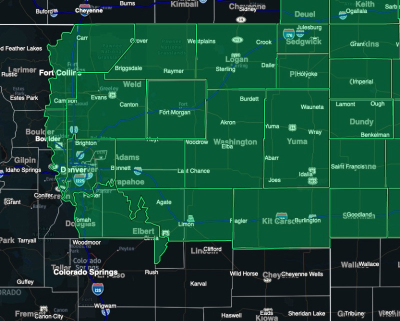
Larimer County Below 6000 Feet/Northwest Weld County-Boulder And Jefferson Counties Below 6000 Feet/West Broomfield County-North Douglas County Below 6000 Feet/Denver/West Adams and Arapahoe Counties/East Broomfield County-Elbert/Central and East Douglas Counties Above 6000 Feet-Northeast Weld County-Central and South Weld County-Morgan County-Central and East Adams and Arapahoe Counties-North and Northeast Elbert County Below 6000 Feet/North Lincoln County-Logan County-Washington County-Sedgwick County-Phillips County-
Including the cities of Castle Rock, Byers, Boulder, Fondis, Elbert, Bennett, Julesburg, Brush, Deer Trail, Merino, Greeley, Matheson, Holyoke, Fort Collins, Littleton, Ovid, Fort Lupton, Pawnee Buttes, Fort Morgan, Crook, City of Denver, Parker, Longmont, Arvada, Loveland, Stoneham, Golden, Brighton, Grover, Hugo, Aurora, Denver International Airport, Otis, Limon, Akron, Highlands Ranch, Cope, Larkspur, Sedgwick, Eaton, Amherst, Kiowa, Goodrich, Hereford, Briggsdale, Sterling, Agate, Raymer, Wiggins, Haxtun, Lakewood, Peetz, Roggen, Last Chance, Nunn, and Leader
252 PM MST Sun Jan 15 2023
...WINTER STORM WATCH IN EFFECT FROM TUESDAY AFTERNOON THROUGH WEDNESDAY AFTERNOON...
* WHAT...Heavy snow possible. Total snow accumulations between 5 and 10 inches possible.
* WHERE...Portions of east central, north central, and northeast Colorado.
* WHEN...From Tuesday afternoon through Wednesday afternoon.
* IMPACTS...Travel may become difficult due to heavy snowfall on roadways. The hazardous conditions could impact the Wednesday morning and Wednesday evening commutes.
PRECAUTIONARY/PREPAREDNESS ACTIONS...
Monitor the latest forecasts for updates on this situation.
For more information from the National Weather Service, visit weather.gov/bou
The NWS in Boulder has issued a Winter Storm Watch from Tuesday afternoon through Wednesday afternoon. (Green highlighted area on map). Heavy snowfall possible. 5 to 10" for parts of the Foothills. Expect difficult travel conditions for the Tuesday afternoon and Wednesday morning commutes.
Low pressure from the Southwestern states should move into Southeast Colorado by late Tuesday, causing favorable upslope conditions with the potential for heavy snow.
Winter Storm Watch
URGENT - WINTER WEATHER MESSAGE
National Weather Service Denver CO
252 PM MST Sun Jan 15 2023
...WINTER STORM POSSIBLE LATE TUESDAY THROUGH WEDNESDAY...
.A storm system will move into Colorado Tuesday night and intensify
over eastern Colorado on Wednesday. Heavy snow may develop Tuesday
night into Wednesday across portions of northeast Colorado. Several
inches of snow will be possible. At this time it`s still to early
to tell where the heaviest snow may fall.
COZ038>046-048>051-160600-
/O.NEW.KBOU.WS.A.0001.230118T0000Z-230119T0000Z/
Larimer County Below 6000 Feet/Northwest Weld County-Boulder And Jefferson Counties Below 6000 Feet/West Broomfield County-North Douglas County Below 6000 Feet/Denver/West Adams and Arapahoe Counties/East Broomfield County-Elbert/Central and East Douglas Counties Above 6000 Feet-Northeast Weld County-Central and South Weld County-Morgan County-Central and East Adams and Arapahoe Counties-North and Northeast Elbert County Below 6000 Feet/North Lincoln County-Logan County-Washington County-Sedgwick County-Phillips County-
Including the cities of Castle Rock, Byers, Boulder, Fondis, Elbert, Bennett, Julesburg, Brush, Deer Trail, Merino, Greeley, Matheson, Holyoke, Fort Collins, Littleton, Ovid, Fort Lupton, Pawnee Buttes, Fort Morgan, Crook, City of Denver, Parker, Longmont, Arvada, Loveland, Stoneham, Golden, Brighton, Grover, Hugo, Aurora, Denver International Airport, Otis, Limon, Akron, Highlands Ranch, Cope, Larkspur, Sedgwick, Eaton, Amherst, Kiowa, Goodrich, Hereford, Briggsdale, Sterling, Agate, Raymer, Wiggins, Haxtun, Lakewood, Peetz, Roggen, Last Chance, Nunn, and Leader
252 PM MST Sun Jan 15 2023
...WINTER STORM WATCH IN EFFECT FROM TUESDAY AFTERNOON THROUGH WEDNESDAY AFTERNOON...
* WHAT...Heavy snow possible. Total snow accumulations between 5 and 10 inches possible.
* WHERE...Portions of east central, north central, and northeast Colorado.
* WHEN...From Tuesday afternoon through Wednesday afternoon.
* IMPACTS...Travel may become difficult due to heavy snowfall on roadways. The hazardous conditions could impact the Wednesday morning and Wednesday evening commutes.
PRECAUTIONARY/PREPAREDNESS ACTIONS...
Monitor the latest forecasts for updates on this situation.
For more information from the National Weather Service, visit weather.gov/bou
Please Log in or Create an account to join the conversation.
- MountainTownAlerts
-
Topic Author
- Mountain Legend
-
Less
More
- Posts: 9766
- Thank you received: 221
16 Jan 2023 16:21 #2
by MountainTownAlerts
Replied by MountainTownAlerts on topic Winter Storm Warning January 17-18, 2023
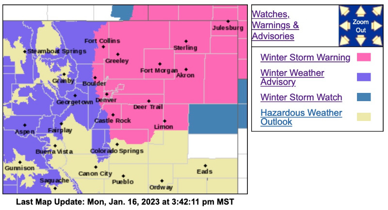
The Winter Storm Watch has been upgraded to a Winter Storm Warning, the higher elevations of Jeffco, Clear Creek, and Park County are now in a Winter Weather Advisory.
Winter Storm Warning
URGENT - WINTER WEATHER MESSAGE
National Weather Service Denver CO
1236 PM MST Mon Jan 16 2023
...WINTER STORM MOVES IN TUESDAY, CONTINUES THROUGH MOST OF WEDNESDAY...
.A storm system will move into Colorado late Tuesday and intensify over eastern Colorado on Wednesday. Snow will develop in the mountains Tuesday afternoon and then spread east across the I-25 Corridor and Plains Tuesday evening. The snow will likely be heavy at times Tuesday night and Wednesday morning, before gradually diminishing Wednesday afternoon. Travel may become difficult late Tuesday night and Wednesday morning.
COZ038>046-048>051-170500-
/O.UPG.KBOU.WS.A.0001.230118T0000Z-230119T0000Z/
/O.NEW.KBOU.WS.W.0002.230118T0000Z-230119T0000Z/
Larimer County Below 6000 Feet/Northwest Weld County-Boulder And Jefferson Counties Below 6000 Feet/West Broomfield County-North Douglas County Below 6000 Feet/Denver/West Adams and Arapahoe Counties/East Broomfield County-Elbert/Central and East Douglas Counties Above 6000 Feet-Northeast Weld County-Central and South Weld County-Morgan County-Central and East Adams and Arapahoe Counties-North and Northeast Elbert County Below 6000 Feet/North Lincoln County-Logan County-Washington County-Sedgwick County- Phillips County-
Including the cities of Matheson, Briggsdale, Ovid, Raymer, Bennett, Haxtun, Parker, Larkspur, Greeley, Aurora, Stoneham, Lakewood, Limon, Sterling, Cope, Kiowa, Castle Rock, Boulder, Amherst, Akron, Highlands Ranch, Otis, Littleton, Fondis, Goodrich, Agate, Loveland, Leader, Pawnee Buttes, Holyoke, Longmont, Brighton, Grover, Nunn, Eaton, Fort Morgan, Crook, Julesburg, Sedgwick, City of Denver, Wiggins, Hereford, Fort Collins, Deer Trail, Elbert, Arvada, Golden, Merino, Last Chance, Roggen, Byers, Denver International Airport, Brush, Peetz, Hugo, and Fort Lupton
1236 PM MST Mon Jan 16 2023
...WINTER STORM WARNING IN EFFECT FROM 5 PM TUESDAY TO 5 PM MST WEDNESDAY...
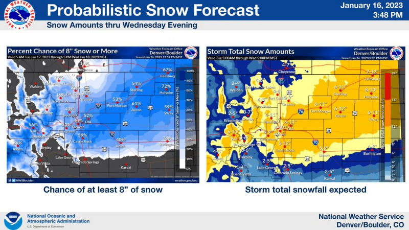
* WHAT...Heavy snow expected. Total snow accumulations between 6 and 11 inches, with the heaviest amounts favored over the plains just east and southeast of Denver. Winds gusting as high as 35 mph east of I-25 with some blowing and drifting snow.
* WHERE...Portions of east central, north central, and northeast Colorado.
* WHEN...From 5 PM Tuesday to 5 PM MST Wednesday. The heaviest snow will spread east across the plains through Tuesday night and continue into Wednesday morning. Snow decreases in intensity from west to east Wednesday afternoon.
* IMPACTS...Travel could be very difficult. The hazardous conditions could impact the Tuesday evening and Wednesday morning commutes.
PRECAUTIONARY/PREPAREDNESS ACTIONS...
If you must travel, keep an extra flashlight, food, and water in your vehicle in case of an emergency. The latest road conditions for Colorado can be obtained by calling 5 1 1 or by going to www.cotrip.org .
_ _ _ _ _ _
Winter Weather Advisory
URGENT - WINTER WEATHER MESSAGE
National Weather Service Denver CO
1236 PM MST Mon Jan 16 2023
COZ031-033>036-170500-
/O.NEW.KBOU.WW.Y.0004.230117T2100Z-230119T0000Z/
West Jackson and West Grand Counties Above 9000 Feet-South and East Jackson/Larimer/North and Northeast Grand/Northwest Boulder Counties Above 9000 Feet-South and Southeast Grand/West Central and Southwest Boulder/Gilpin/Clear Creek/Summit/North and West Park Counties Above 9000 Feet-Larimer and Boulder Counties Between 6000 and 9000 Feet-Jefferson and West Douglas Counties Above 6000 Feet/Gilpin/Clear Creek/Northeast Park Counties Below 9000 Feet-
Including the cities of Bailey, Central City, Estes Park, Westcreek, Kenosha Mountains, Willow Creek Pass, Winter Park, Eisenhower Tunnel, Red Feather Lakes, Cameron Pass, Williams Fork Mountains, East Slopes Mosquito Range, Indian Peaks, Georgetown, Rocky Mountain National Park, Laramie and Medicine Bow Mountains, Berthoud Pass, Breckenridge, Mt Zirkel, Glendevey, East Slopes Southern Gore Range, Nederland, Evergreen, Mount Evans, Rabbit Ears Range, and Idaho Springs
1236 PM MST Mon Jan 16 2023
...WINTER WEATHER ADVISORY IN EFFECT FROM 2 PM TUESDAY TO 5 PM MST WEDNESDAY...
* WHAT...Snow expected. Total snow accumulations between 5 and 10 inches, with up to 12 inches possible in the mountains of Summit County. Winds gusting as high as 35 mph.
* WHERE...Rabbit Ears Pass, Rocky Mountain National Park and the Medicine Bow Range, The Mountains of Summit County, the Mosquito Range, and the Indian Peaks, The Northern Front Range Foothills, and The Southern Front Range Foothills.
* WHEN...From 2 PM Tuesday to 5 PM MST Wednesday.
* IMPACTS...Travel could be difficult. The hazardous conditions could impact the Tuesday evening and Wednesday morning commutes.
PRECAUTIONARY/PREPAREDNESS ACTIONS...
Slow down and use caution while traveling. The latest road conditions for Colorado can be obtained by calling 5 1 1 or by going to www.cotrip.org .
For more information from the National Weather Service, visit weather.gov/bou
Winter Storm Warning
URGENT - WINTER WEATHER MESSAGE
National Weather Service Denver CO
1236 PM MST Mon Jan 16 2023
...WINTER STORM MOVES IN TUESDAY, CONTINUES THROUGH MOST OF WEDNESDAY...
.A storm system will move into Colorado late Tuesday and intensify over eastern Colorado on Wednesday. Snow will develop in the mountains Tuesday afternoon and then spread east across the I-25 Corridor and Plains Tuesday evening. The snow will likely be heavy at times Tuesday night and Wednesday morning, before gradually diminishing Wednesday afternoon. Travel may become difficult late Tuesday night and Wednesday morning.
COZ038>046-048>051-170500-
/O.UPG.KBOU.WS.A.0001.230118T0000Z-230119T0000Z/
/O.NEW.KBOU.WS.W.0002.230118T0000Z-230119T0000Z/
Larimer County Below 6000 Feet/Northwest Weld County-Boulder And Jefferson Counties Below 6000 Feet/West Broomfield County-North Douglas County Below 6000 Feet/Denver/West Adams and Arapahoe Counties/East Broomfield County-Elbert/Central and East Douglas Counties Above 6000 Feet-Northeast Weld County-Central and South Weld County-Morgan County-Central and East Adams and Arapahoe Counties-North and Northeast Elbert County Below 6000 Feet/North Lincoln County-Logan County-Washington County-Sedgwick County- Phillips County-
Including the cities of Matheson, Briggsdale, Ovid, Raymer, Bennett, Haxtun, Parker, Larkspur, Greeley, Aurora, Stoneham, Lakewood, Limon, Sterling, Cope, Kiowa, Castle Rock, Boulder, Amherst, Akron, Highlands Ranch, Otis, Littleton, Fondis, Goodrich, Agate, Loveland, Leader, Pawnee Buttes, Holyoke, Longmont, Brighton, Grover, Nunn, Eaton, Fort Morgan, Crook, Julesburg, Sedgwick, City of Denver, Wiggins, Hereford, Fort Collins, Deer Trail, Elbert, Arvada, Golden, Merino, Last Chance, Roggen, Byers, Denver International Airport, Brush, Peetz, Hugo, and Fort Lupton
1236 PM MST Mon Jan 16 2023
...WINTER STORM WARNING IN EFFECT FROM 5 PM TUESDAY TO 5 PM MST WEDNESDAY...
* WHAT...Heavy snow expected. Total snow accumulations between 6 and 11 inches, with the heaviest amounts favored over the plains just east and southeast of Denver. Winds gusting as high as 35 mph east of I-25 with some blowing and drifting snow.
* WHERE...Portions of east central, north central, and northeast Colorado.
* WHEN...From 5 PM Tuesday to 5 PM MST Wednesday. The heaviest snow will spread east across the plains through Tuesday night and continue into Wednesday morning. Snow decreases in intensity from west to east Wednesday afternoon.
* IMPACTS...Travel could be very difficult. The hazardous conditions could impact the Tuesday evening and Wednesday morning commutes.
PRECAUTIONARY/PREPAREDNESS ACTIONS...
If you must travel, keep an extra flashlight, food, and water in your vehicle in case of an emergency. The latest road conditions for Colorado can be obtained by calling 5 1 1 or by going to www.cotrip.org .
_ _ _ _ _ _
Winter Weather Advisory
URGENT - WINTER WEATHER MESSAGE
National Weather Service Denver CO
1236 PM MST Mon Jan 16 2023
COZ031-033>036-170500-
/O.NEW.KBOU.WW.Y.0004.230117T2100Z-230119T0000Z/
West Jackson and West Grand Counties Above 9000 Feet-South and East Jackson/Larimer/North and Northeast Grand/Northwest Boulder Counties Above 9000 Feet-South and Southeast Grand/West Central and Southwest Boulder/Gilpin/Clear Creek/Summit/North and West Park Counties Above 9000 Feet-Larimer and Boulder Counties Between 6000 and 9000 Feet-Jefferson and West Douglas Counties Above 6000 Feet/Gilpin/Clear Creek/Northeast Park Counties Below 9000 Feet-
Including the cities of Bailey, Central City, Estes Park, Westcreek, Kenosha Mountains, Willow Creek Pass, Winter Park, Eisenhower Tunnel, Red Feather Lakes, Cameron Pass, Williams Fork Mountains, East Slopes Mosquito Range, Indian Peaks, Georgetown, Rocky Mountain National Park, Laramie and Medicine Bow Mountains, Berthoud Pass, Breckenridge, Mt Zirkel, Glendevey, East Slopes Southern Gore Range, Nederland, Evergreen, Mount Evans, Rabbit Ears Range, and Idaho Springs
1236 PM MST Mon Jan 16 2023
...WINTER WEATHER ADVISORY IN EFFECT FROM 2 PM TUESDAY TO 5 PM MST WEDNESDAY...
* WHAT...Snow expected. Total snow accumulations between 5 and 10 inches, with up to 12 inches possible in the mountains of Summit County. Winds gusting as high as 35 mph.
* WHERE...Rabbit Ears Pass, Rocky Mountain National Park and the Medicine Bow Range, The Mountains of Summit County, the Mosquito Range, and the Indian Peaks, The Northern Front Range Foothills, and The Southern Front Range Foothills.
* WHEN...From 2 PM Tuesday to 5 PM MST Wednesday.
* IMPACTS...Travel could be difficult. The hazardous conditions could impact the Tuesday evening and Wednesday morning commutes.
PRECAUTIONARY/PREPAREDNESS ACTIONS...
Slow down and use caution while traveling. The latest road conditions for Colorado can be obtained by calling 5 1 1 or by going to www.cotrip.org .
For more information from the National Weather Service, visit weather.gov/bou
Please Log in or Create an account to join the conversation.
- Forum
- Life Up the Hill
- Scanner & Emergency Info, Weather Forecasts
- Winter Storm Warning January 17-18, 2023
Time to create page: 0.178 seconds
sponsors


