- Posts: 9766
- Thank you received: 221
- Forum
- Life Up the Hill
- Scanner & Emergency Info, Weather Forecasts
- Winter Storm Warning & Advisory February 14-15, 2023
Winter Storm Warning & Advisory February 14-15, 2023
- MountainTownAlerts
-
 Topic Author
- Mountain Legend
-

Less
More
13 Feb 2023 20:57 #1
by MountainTownAlerts
From Chief Meteorologist Steve Hamilton:
Snow And Cold Coming...
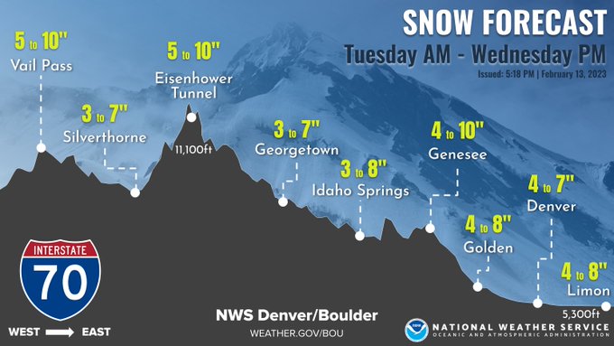
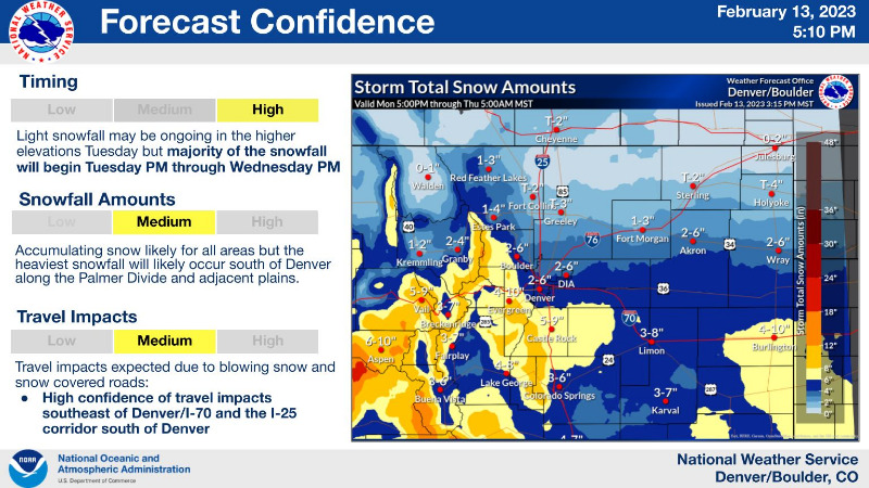
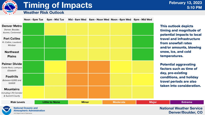
Some snow showers from the first low pressure system will be possible, mainly in the higher mountains, on Tuesday morning. With a second system moving in, a low will develop over southeast Colorado, we can expect very gusty wind throughout the foothills Tuesday, at 25 to 35 mph, and perhaps as high as 45 mph. By Tuesday evening, we should have favorable upslope conditions, and sufficient moisture for a few inches of snowfall. Amounts could top 7 or 8" for some locations Tuesday night. Temperatures will be cold, and combined with the gusty wind, our wind chills could drop to -15. Tuesday night into Wednesday, some areas of heavy or banded snow will be possible. Several inches of snow is also possible for the Denver metro, with slick roads expected through the Wednesday morning commute.
mymountaintown.com/expert-local-weather
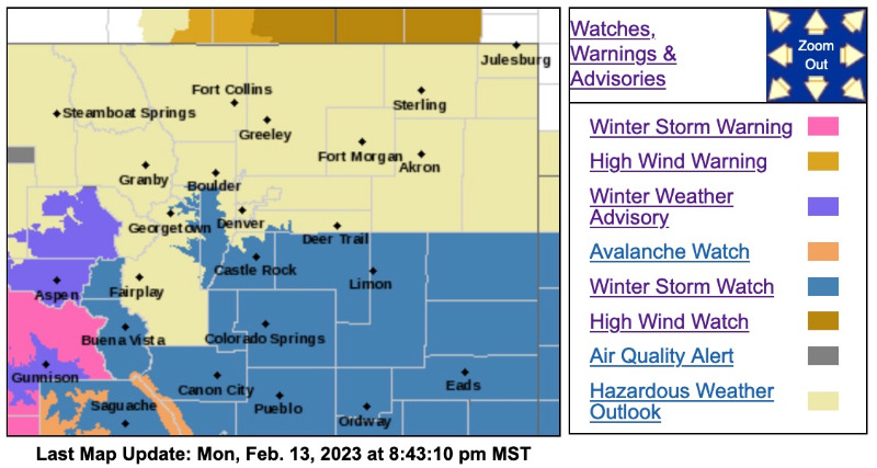
Winter Storm Watch
URGENT - WINTER WEATHER MESSAGE
National Weather Service Denver CO
201 PM MST Mon Feb 13 2023
COZ036-141115-
/O.EXA.KBOU.WS.A.0003.230215T0000Z-230216T0700Z/
Jefferson and West Douglas Counties Above 6000 Feet/Gilpin/Clear Creek/Northeast Park Counties Below 9000 Feet-
Including the cities of Bailey, Idaho Springs, Georgetown, Evergreen, Westcreek, and Central City
201 PM MST Mon Feb 13 2023
...WINTER STORM WATCH IN EFFECT FROM TUESDAY LATE AFTERNOON THROUGH WEDNESDAY EVENING...
* WHAT...Heavy snow possible. Total snow accumulations between 5 and 11 inches possible. Winds could gust as high as 35 mph.
* WHERE...The Southern Front Range Foothills.
* WHEN...From late Tuesday afternoon through Wednesday evening.
* IMPACTS...Roads will likely become slick and hazardous. Travel could be very difficult. The hazardous conditions could impact the Wednesday morning commute.
PRECAUTIONARY/PREPAREDNESS ACTIONS...
Monitor the latest forecasts for updates on this situation.

Snow And Cold Coming...
Some snow showers from the first low pressure system will be possible, mainly in the higher mountains, on Tuesday morning. With a second system moving in, a low will develop over southeast Colorado, we can expect very gusty wind throughout the foothills Tuesday, at 25 to 35 mph, and perhaps as high as 45 mph. By Tuesday evening, we should have favorable upslope conditions, and sufficient moisture for a few inches of snowfall. Amounts could top 7 or 8" for some locations Tuesday night. Temperatures will be cold, and combined with the gusty wind, our wind chills could drop to -15. Tuesday night into Wednesday, some areas of heavy or banded snow will be possible. Several inches of snow is also possible for the Denver metro, with slick roads expected through the Wednesday morning commute.
mymountaintown.com/expert-local-weather
Winter Storm Watch
URGENT - WINTER WEATHER MESSAGE
National Weather Service Denver CO
201 PM MST Mon Feb 13 2023
COZ036-141115-
/O.EXA.KBOU.WS.A.0003.230215T0000Z-230216T0700Z/
Jefferson and West Douglas Counties Above 6000 Feet/Gilpin/Clear Creek/Northeast Park Counties Below 9000 Feet-
Including the cities of Bailey, Idaho Springs, Georgetown, Evergreen, Westcreek, and Central City
201 PM MST Mon Feb 13 2023
...WINTER STORM WATCH IN EFFECT FROM TUESDAY LATE AFTERNOON THROUGH WEDNESDAY EVENING...
* WHAT...Heavy snow possible. Total snow accumulations between 5 and 11 inches possible. Winds could gust as high as 35 mph.
* WHERE...The Southern Front Range Foothills.
* WHEN...From late Tuesday afternoon through Wednesday evening.
* IMPACTS...Roads will likely become slick and hazardous. Travel could be very difficult. The hazardous conditions could impact the Wednesday morning commute.
PRECAUTIONARY/PREPAREDNESS ACTIONS...
Monitor the latest forecasts for updates on this situation.
Please Log in or Create an account to join the conversation.
- MountainTownAlerts
-
Topic Author
- Mountain Legend
-
Less
More
- Posts: 9766
- Thank you received: 221
14 Feb 2023 17:52 #2
by MountainTownAlerts
Replied by MountainTownAlerts on topic Winter Storm Warning & Advisory February 14-15, 2023
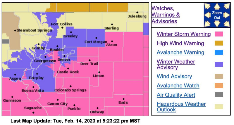
The Winter Storm Watch has been upgraded and is no longer in effect.

Winter Storm Warning
URGENT - WINTER WEATHER MESSAGE
National Weather Service Denver CO
212 PM MST Tue Feb 14 2023
COZ036-041-151100-
/O.CON.KBOU.WS.W.0006.230215T0000Z-230216T0700Z/
Jefferson and West Douglas Counties Above 6000 Feet/Gilpin/Clear Creek/Northeast Park Counties Below 9000 Feet-Elbert/Central and East Douglas Counties Above 6000 Feet-
Including the cities of Larkspur, Kiowa, Bailey, Georgetown, Fondis, Central City, Elbert, Westcreek, Evergreen, Castle Rock, and Idaho Springs
212 PM MST Tue Feb 14 2023
...WINTER STORM WARNING REMAINS IN EFFECT UNTIL MIDNIGHT MST WEDNESDAY NIGHT...
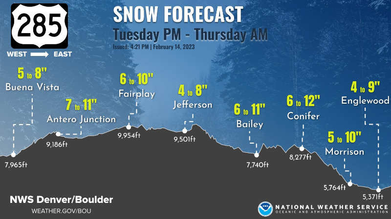
* WHAT...Heavy snow expected. Total snow accumulations between 6 and 12 inches with higher amounts possible in the southern foothills. Winds gusting as high as 40 mph.
* WHERE...The Southern Front Range Foothills, and Castle Rock.
* WHEN...Until Midnight MST Wednesday Night.
* IMPACTS...Roads will likely become slick and hazardous. Travel could be very difficult. Areas of blowing snow could significantly reduce visibility. The hazardous conditions could impact the Tuesday evening and Wednesday morning commutes.
PRECAUTIONARY/PREPAREDNESS ACTIONS...
If you must travel, keep an extra flashlight, food, and water in your vehicle in case of an emergency. The latest road conditions for Colorado can be obtained by calling 5 1 1 or by going to www.cotrip.org .
Chain and traction laws will possibly be enacted for the mountains. If traveling to the mountains, be prepared for winter driving conditions.
_ _ _ _ _ _ _ _ _ _ _ _ _ _ _ _ _ _ _ _ _ _ _ _ _ _ _ _ _ _ _ _ _ _ _ _ _ _ _ _ _ _
Winter Weather Advisory
URGENT - WINTER WEATHER MESSAGE
National Weather Service Denver CO
543 PM MST Tue Feb 14 2023
...WINTER STORM TO BRING HEAVY SNOW TO PORTIONS OF THE MOUNTAINS AND PLAINS...
.A winter storm will bring snow, heavy at times, to most areas roughly along and south of I-70 through Wednesday evening. The heaviest snow is expected in the mountains surrounding Park County, the southern foothills, the Palmer Divide (including I-25 between Denver and Colorado Springs), and possibly portions of I-70 through the plains. Snow will be heaviest tonight into Wednesday morning, with lighter snow lingering much of the day on Wednesday. In addition, gusty winds will lead to localized blowing snow concerns.
COZ034-151300-
/O.CON.KBOU.WW.Y.0012.000000T0000Z-230216T0700Z/
South and Southeast Grand/West Central and Southwest Boulder/Gilpin/Clear Creek/Summit/North and West Park Counties Above 9000 Feet-
Including the cities of Berthoud Pass, Indian Peaks, Williams Fork Mountains, Breckenridge, East Slopes Southern Gore Range, Eisenhower Tunnel, East Slopes Mosquito Range, Winter Park, Kenosha Mountains, and Mount Evans
543 PM MST Tue Feb 14 2023
...WINTER WEATHER ADVISORY REMAINS IN EFFECT UNTIL MIDNIGHT MST WEDNESDAY NIGHT...
* WHAT...Snow expected. Total snow accumulations between 4 and 12 inches. Winds gusting as high as 40 mph. Heaviest snow expected in the mountains of Park County.
* WHERE...The Mountains of Summit and Park Counties, the Mosquito Range, and the Indian Peaks.
* WHEN...Until Midnight MST Wednesday Night.
* IMPACTS...Snow covered roads will make travel hazardous.
_ _ _ _ _ _ _ _ _ _ _ _ _ _ _ _ _ _ _ _ _ _ _ _
URGENT - WINTER WEATHER MESSAGE
National Weather Service Denver CO
543 PM MST Tue Feb 14 2023
...WINTER STORM TO BRING HEAVY SNOW TO PORTIONS OF THE MOUNTAINS AND PLAINS...
COZ039-040-151300-
/O.CON.KBOU.WW.Y.0012.230215T0700Z-230216T0700Z/
Boulder And Jefferson Counties Below 6000 Feet/West Broomfield County-North Douglas County Below 6000 Feet/Denver/West Adams and Arapahoe Counties/East Broomfield County-
Including the cities of Denver International Airport, Aurora, Parker, City of Denver, Highlands Ranch, Boulder, Lakewood, Arvada, Littleton, Longmont, Golden, and Brighton
543 PM MST Tue Feb 14 2023
...WINTER WEATHER ADVISORY REMAINS IN EFFECT FROM MIDNIGHT TONIGHT TO MIDNIGHT MST WEDNESDAY NIGHT...
* WHAT...Snow expected. Total snow accumulations between 4 and 8 inches with the highest amounts on the southwest side of the Denver metro.
* WHERE...Denver, Boulder, and western Adams and Arapahoe Counties.
* WHEN...From Midnight tonight to Midnight MST Wednesday Night.
* IMPACTS...Snow covered roads will make travel hazardous. Plan on slippery road conditions. The hazardous conditions could impact the Wednesday morning and evening commutes.
PRECAUTIONARY/PREPAREDNESS ACTIONS...
Slow down and use caution while traveling. The latest road conditions for Colorado can be obtained by calling 5 1 1 or by going to www.cotrip.org .
Monitor the latest forecasts for updates on this situation. Shifts in the storm track could significantly impact snowfall totals.
Winter Storm Warning
URGENT - WINTER WEATHER MESSAGE
National Weather Service Denver CO
212 PM MST Tue Feb 14 2023
COZ036-041-151100-
/O.CON.KBOU.WS.W.0006.230215T0000Z-230216T0700Z/
Jefferson and West Douglas Counties Above 6000 Feet/Gilpin/Clear Creek/Northeast Park Counties Below 9000 Feet-Elbert/Central and East Douglas Counties Above 6000 Feet-
Including the cities of Larkspur, Kiowa, Bailey, Georgetown, Fondis, Central City, Elbert, Westcreek, Evergreen, Castle Rock, and Idaho Springs
212 PM MST Tue Feb 14 2023
...WINTER STORM WARNING REMAINS IN EFFECT UNTIL MIDNIGHT MST WEDNESDAY NIGHT...
* WHAT...Heavy snow expected. Total snow accumulations between 6 and 12 inches with higher amounts possible in the southern foothills. Winds gusting as high as 40 mph.
* WHERE...The Southern Front Range Foothills, and Castle Rock.
* WHEN...Until Midnight MST Wednesday Night.
* IMPACTS...Roads will likely become slick and hazardous. Travel could be very difficult. Areas of blowing snow could significantly reduce visibility. The hazardous conditions could impact the Tuesday evening and Wednesday morning commutes.
PRECAUTIONARY/PREPAREDNESS ACTIONS...
If you must travel, keep an extra flashlight, food, and water in your vehicle in case of an emergency. The latest road conditions for Colorado can be obtained by calling 5 1 1 or by going to www.cotrip.org .
Chain and traction laws will possibly be enacted for the mountains. If traveling to the mountains, be prepared for winter driving conditions.
_ _ _ _ _ _ _ _ _ _ _ _ _ _ _ _ _ _ _ _ _ _ _ _ _ _ _ _ _ _ _ _ _ _ _ _ _ _ _ _ _ _
Winter Weather Advisory
URGENT - WINTER WEATHER MESSAGE
National Weather Service Denver CO
543 PM MST Tue Feb 14 2023
...WINTER STORM TO BRING HEAVY SNOW TO PORTIONS OF THE MOUNTAINS AND PLAINS...
.A winter storm will bring snow, heavy at times, to most areas roughly along and south of I-70 through Wednesday evening. The heaviest snow is expected in the mountains surrounding Park County, the southern foothills, the Palmer Divide (including I-25 between Denver and Colorado Springs), and possibly portions of I-70 through the plains. Snow will be heaviest tonight into Wednesday morning, with lighter snow lingering much of the day on Wednesday. In addition, gusty winds will lead to localized blowing snow concerns.
COZ034-151300-
/O.CON.KBOU.WW.Y.0012.000000T0000Z-230216T0700Z/
South and Southeast Grand/West Central and Southwest Boulder/Gilpin/Clear Creek/Summit/North and West Park Counties Above 9000 Feet-
Including the cities of Berthoud Pass, Indian Peaks, Williams Fork Mountains, Breckenridge, East Slopes Southern Gore Range, Eisenhower Tunnel, East Slopes Mosquito Range, Winter Park, Kenosha Mountains, and Mount Evans
543 PM MST Tue Feb 14 2023
...WINTER WEATHER ADVISORY REMAINS IN EFFECT UNTIL MIDNIGHT MST WEDNESDAY NIGHT...
* WHAT...Snow expected. Total snow accumulations between 4 and 12 inches. Winds gusting as high as 40 mph. Heaviest snow expected in the mountains of Park County.
* WHERE...The Mountains of Summit and Park Counties, the Mosquito Range, and the Indian Peaks.
* WHEN...Until Midnight MST Wednesday Night.
* IMPACTS...Snow covered roads will make travel hazardous.
_ _ _ _ _ _ _ _ _ _ _ _ _ _ _ _ _ _ _ _ _ _ _ _
URGENT - WINTER WEATHER MESSAGE
National Weather Service Denver CO
543 PM MST Tue Feb 14 2023
...WINTER STORM TO BRING HEAVY SNOW TO PORTIONS OF THE MOUNTAINS AND PLAINS...
COZ039-040-151300-
/O.CON.KBOU.WW.Y.0012.230215T0700Z-230216T0700Z/
Boulder And Jefferson Counties Below 6000 Feet/West Broomfield County-North Douglas County Below 6000 Feet/Denver/West Adams and Arapahoe Counties/East Broomfield County-
Including the cities of Denver International Airport, Aurora, Parker, City of Denver, Highlands Ranch, Boulder, Lakewood, Arvada, Littleton, Longmont, Golden, and Brighton
543 PM MST Tue Feb 14 2023
...WINTER WEATHER ADVISORY REMAINS IN EFFECT FROM MIDNIGHT TONIGHT TO MIDNIGHT MST WEDNESDAY NIGHT...
* WHAT...Snow expected. Total snow accumulations between 4 and 8 inches with the highest amounts on the southwest side of the Denver metro.
* WHERE...Denver, Boulder, and western Adams and Arapahoe Counties.
* WHEN...From Midnight tonight to Midnight MST Wednesday Night.
* IMPACTS...Snow covered roads will make travel hazardous. Plan on slippery road conditions. The hazardous conditions could impact the Wednesday morning and evening commutes.
PRECAUTIONARY/PREPAREDNESS ACTIONS...
Slow down and use caution while traveling. The latest road conditions for Colorado can be obtained by calling 5 1 1 or by going to www.cotrip.org .
Monitor the latest forecasts for updates on this situation. Shifts in the storm track could significantly impact snowfall totals.
Please Log in or Create an account to join the conversation.
- Forum
- Life Up the Hill
- Scanner & Emergency Info, Weather Forecasts
- Winter Storm Warning & Advisory February 14-15, 2023
Time to create page: 0.244 seconds
sponsors


