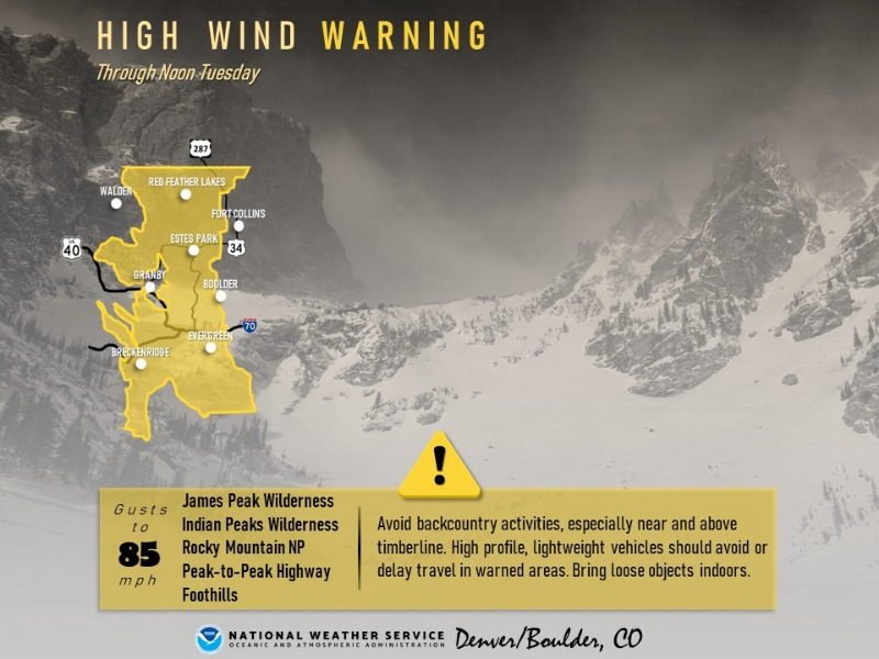
High Wind Warning
URGENT - WEATHER MESSAGE
National Weather Service Denver CO
255 PM MST Sun Feb 19 2023
COZ033>036-201300-
/O.CON.KBOU.HW.W.0001.230219T2200Z-230221T1900Z/
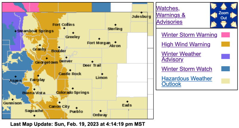
South and East Jackson/Larimer/North and Northeast Grand/Northwest Boulder Counties Above 9000 Feet-South and Southeast Grand/West Central and Southwest Boulder/Gilpin/
Clear Creek/Summit/North and West Park Counties Above 9000 Feet-Larimer and Boulder Counties Between 6000 and 9000 Feet-
Jefferson and West Douglas Counties Above 6000 Feet/Gilpin/Clear Creek/Northeast Park Counties Below 9000 Feet-
Including the cities of Bailey, East Slopes Mosquito Range, Winter Park, Rabbit Ears Range, Indian Peaks, Central City, Willow Creek Pass, Williams Fork Mountains,
Evergreen/b], Cameron Pass, Rocky Mountain National Park, Berthoud Pass,
East Slopes Southern Gore Range, Idaho Springs/b], Estes Park, Kenosha Mountains, Westcreek, Glendevey,
Mount Evans, Eisenhower Tunnel/b], Laramie and Medicine Bow Mountains,
Breckenridge/b], Red Feather Lakes,
Georgetown/b], and Nederland
255 PM MST Sun Feb 19 2023
...HIGH WIND WARNING REMAINS IN EFFECT UNTIL NOON MST TUESDAY...
* WHAT...
West winds 40 to 50 mph with gusts up to 85 mph expected.
* WHERE...Rocky Mountain National Park and the Medicine Bow Range, The Mountains of Summit County, the Mosquito Range, and the Indian Peaks, The Northern Front Range Foothills, and The Southern Front Range Foothills.
* WHEN...
From 3 PM this afternoon to Noon MST Tuesday. There may be multiple periods of strongest winds during this prolonged wind event. One is forecast for this evening through the overnight tonight, and another is possible Monday night into Tuesday morning.
* IMPACTS...Damaging winds may blow down trees and power lines. Isolated power outages are expected. Travel will be difficult, especially for high profile vehicles.
PRECAUTIONARY/PREPAREDNESS ACTIONS...
Watch for falling debris and tree limbs. Use caution if you must drive.
For more information from the National Weather Service, visit
weather.gov/bou