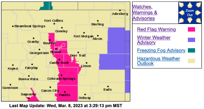
Red Flag Warning
URGENT - FIRE WEATHER MESSAGE
National Weather Service Denver/Boulder CO
321 PM MST Wed Mar 8 2023
COZ239>241-091200-
/O.NEW.KBOU.FW.W.0003.230309T1800Z-230310T0000Z/
Boulder And Jefferson Counties Below 6000 Feet/West Broomfield County-North Douglas County Below 6000 Feet/Denver/West Adams and Arapahoe Counties/East Broomfield County-Elbert/Central and East Douglas Counties Above 6000 Feet-
321 PM MST Wed Mar 8 2023
...
RED FLAG WARNING IN EFFECT FROM 11 AM TO 5 PM MST THURSDAY FOR WIND AND LOW RELATIVE HUMIDITY FOR THE DENVER/BOULDER AREA, EASTERN DOUGLAS, AND WESTERN ELBERT COUNTIES...FIRE WEATHER ZONES 239 THROUGH 241...
The National Weather Service in Denver has issued a Red Flag Warning for wind and low relative humidity, which is in effect from 11 AM to 5 PM MST Thursday.
* Affected Area...Fire Weather Zones 239, 240 and 241.
* Timing...Strong west winds will develop Thursday morning, with humidities lowering as the day goes on. Winds will start to decrease later in the afternoon.
* Winds...Northwest 20 to 30 mph with gusts up to 45 mph.
* Relative Humidity...As low as 15 percent.
* Impacts...Conditions will be favorable for rapid fire spread. Avoid outdoor burning and any activities that may produce sparks.
PRECAUTIONARY/PREPAREDNESS ACTIONS...
A Red Flag Warning means that critical fire weather conditions are either occurring now....or will shortly. A combination of strong winds...low relative humidity...and warm temperatures can contribute to extreme fire behavior.