Red Flag Warning
URGENT - FIRE WEATHER MESSAGE
National Weather Service Denver/Boulder CO
655 PM MDT Fri Mar 31 2023
...CRITICAL FIRE WEATHER CONDITIONS EXPECTED AGAIN ON SATURDAY...
Very strong and gusty west to northwest winds that we observed today will gradually diminish early this evening. However, only moderate humidity recovery will occur overnight.
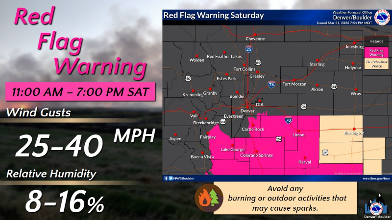
On Saturday, we`ll turn warmer which means somewhat lower humidity readings. Fortunately winds will be lighter, but at the same time still reach Red Flag Criteria over the southern portions of our forecast area from Park County eastward across the Palmer Divide. Winds gusting to 25 to 30 mph will coincide with minimum humidity values of 10 to 16 percent.
Sunday will feature increasing winds and even warmer temperatures, so more widespread critical fire weather conditions can be expected then. Monday should finally start a cooldown, but southern portions around Park County and adjacent areas toward the Palmer Divide could still stay windy and warm.
COZ214-241-246-247-010900-
/O.CAN.KBOU.FW.W.0006.000000T0000Z-230401T0100Z/
/O.CON.KBOU.FW.W.0007.230401T1700Z-230402T0200Z/
Central and Southeast Park County-Elbert/Central and East Douglas Counties Above 6000 Feet-North and Northeast Elbert County Below 6000 Feet/North Lincoln County-Southeast Elbert County Below 6000 Feet/South Lincoln County-
655 PM MDT Fri Mar 31 2023
...
RED FLAG WARNING REMAINS IN EFFECT FROM 11 AM TO 8 PM MDT SATURDAY FOR WIND AND LOW RELATIVE HUMIDITY FOR SOUTH PARK...FIRE WEATHER ZONE 214...
...RED FLAG WARNING HAS EXPIRED FOR WIND AND LOW RELATIVE HUMIDITY FOR SOUTH PARK...FIRE WEATHER ZONE 214...
The National Weather Service in Denver has cancelled the Red Flag Warning.
* Affected Area...Fire Weather Zones 214, 241, 246 and 247.
* Timing...Until 7 PM MDT this evening, and then 11 am to 8 PM MDT Saturday.
* Winds...Southwest 15 to 25 mph with gusts up to 40 mph.
* Relative Humidity...As low as 10 percent.
* Impacts...Conditions will be favorable for rapid fire spread. Avoid outdoor burning and any activities that may produce sparks.
PRECAUTIONARY/PREPAREDNESS ACTIONS...
A Red Flag Warning means that critical fire weather conditions are either occurring now....or will shortly. A combination of strong winds...low relative humidity...and warm temperatures can contribute to extreme fire behavior.