Chief Meteorologist Steve Hamilton:
My Mountain Town Weather: UPDATE
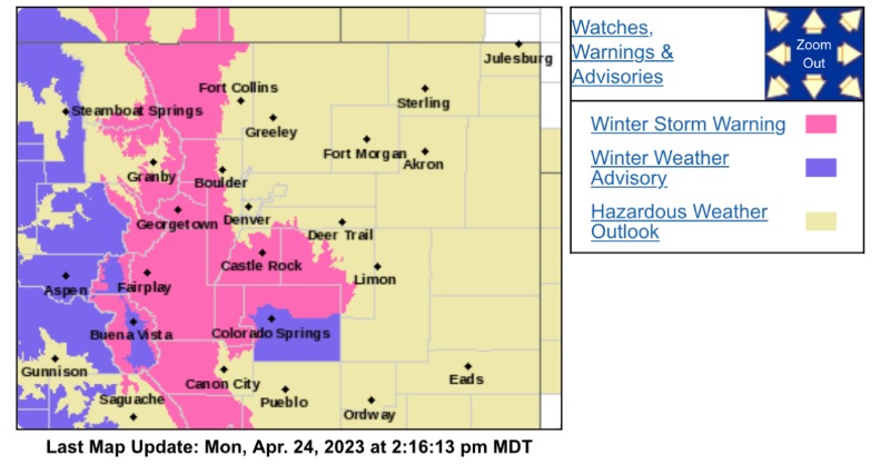
WINTER STORM WARNING...
A winter storm warning is in effect from 6AM Tuesday until Noon Wednesday. Heavy snow expected.
Widespread storm total accumulations between 8 and 16 inches, with local amounts up to to 25 inches.
Highest potential for 2 ft snow totals for the upper elevations of Park, Jefferson and Clear Creek Counties.
Check back for updates:
mymountaintown.com/expert-local-weather
EATHER MESSAGE
National Weather Service Denver CO
145 PM MDT Mon Apr 24 2023
...IMPACTFUL WINTER STORM TUESDAY INTO EARLY WEDNESDAY...
.A winter storm will impact the area Tuesday through Wednesday morning, and will produce a period of heavy snow particularly from Tuesday afternoon through early Wednesday morning. Widespread storm total snowfall amounts between 8 and 16 inches are expected for most of the mountains and upper elevations of the foothills. Snowfall rates of 2 inches per hour will be possible during the heavier snowfall Tuesday evening and Tuesday night, and travel will likely be very difficult during this period. Snow levels will lower Tuesday evening and overnight, with increasing potential for impactful accumulations over the Palmer Divide between Castle Rock and Colorado Springs.
COZ033>037-250400-
/O.UPG.KBOU.WS.A.0007.230425T1200Z-230426T1800Z/
/O.NEW.KBOU.WS.W.0011.230425T1200Z-230426T1800Z/
South and East Jackson/Larimer/North and Northeast Grand/Northwest Boulder Counties Above 9000 Feet-South and Southeast Grand/West Central and Southwest Boulder/Gilpin/
Clear Creek/Summit/North and West Park Counties Above 9000 Feet-Larimer and Boulder Counties Between 6000 and 9000 Feet-
Jefferson and West Douglas Counties Above 6000 Feet/Gilpin/Clear Creek/Northeast Park Counties Below 9000 Feet-Central and Southeast Park County-
Including the cities of Central City, East Slopes Mosquito Range, Bailey, Red Feather Lakes, Idaho Springs, Westcreek, Nederland, East Slopes Southern Gore Range, Eisenhower Tunnel, Estes Park, Breckenridge, South Park, Lake George, Mount Evans, Glendevey, Cameron Pass, Evergreen, Kenosha Mountains, Willow Creek Pass, Winter Park, Williams Fork Mountains, Fairplay, Rocky Mountain National Park, Berthoud Pass, Laramie and Medicine Bow Mountains, Georgetown, Hartsel, Indian Peaks, and Rabbit Ears Range
145 PM MDT Mon Apr 24 2023
...WINTER STORM WARNING IN EFFECT FROM 6 AM TUESDAY TO NOON MDT WEDNESDAY...
* WHAT...Heavy snow expected. Widespread storm total accumulations between 8 and 16 inches, with local amounts to 25 inches for favored areas.
* WHERE...Front Range mountains, including Rocky Mountain NP, the Indian Peaks Wilderness, and the Eisenhower Tunnel, in addition to foothill areas above 7,500 ft. Highest potential for 2 ft snow totals for the upper elevations of Park, Jefferson and Clear Creek Counties.
* WHEN...From Tuesday morning through Wednesday morning. Heaviest snowfall expected from mid afternoon Tuesday through daybreak Wednesday.
* IMPACTS...Travel may become very difficult to impossible due to heavy snowfall on roadways. The hazardous conditions could impact the Tuesday evening commute.
PRECAUTIONARY/PREPAREDNESS ACTIONS...
Monitor the latest forecasts for updates on this situation.
Persons should consider delaying travel. If travel is absolutely necessary, drive with extreme caution. Consider taking a winter storm kit along with you, including such items as tire chains, booster cables, flashlight, shovel, blankets and extra clothing. Also take water, a first aid kit, and anything else that would help you survive in case you become stranded.