From Chief Meteorologist Steve Hamilton:
My Mountain Town Weather: Flash Flooding Possible...
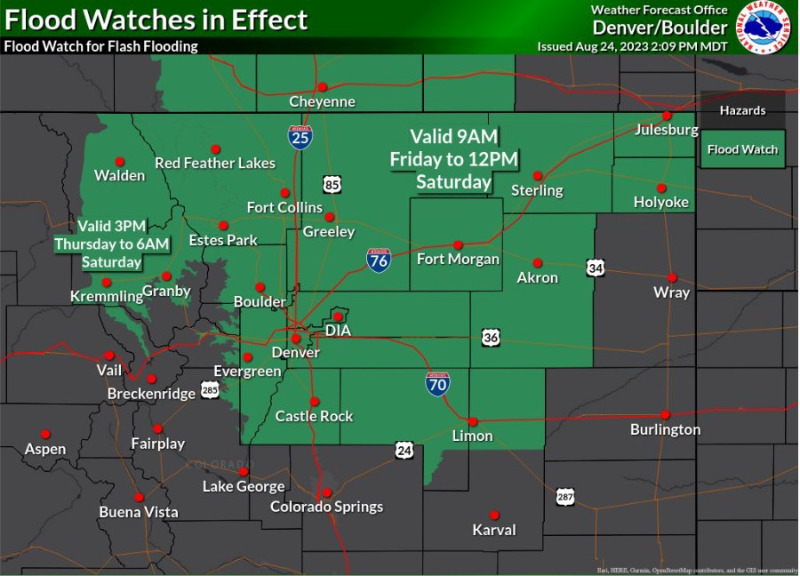
The National Weather Service in Boulder has issued a Flood Watch for the green highlighted areas of the Foothills. From Friday morning through Noon Saturday, locally heavy rainfall, and excessive runoff may cause flash flooding of creeks, streams and rivers. Urban street flooding in poor drainage areas is also possible. Reminder: Never drive through moving water.
Flood Watch
National Weather Service Denver CO
153 PM MDT Thu Aug 24 2023
COZ035-036-038>046-048>051-251200-
/O.NEW.KBOU.FA.A.0012.230825T1500Z-230826T1800Z/
/00000.0.ER.000000T0000Z.000000T0000Z.000000T0000Z.OO/
Larimer and Boulder Counties Between 6000 and 9000 Feet-
Jefferson and West Douglas Counties Above 6000 Feet/Gilpin/Clear Creek/Northeast Park Counties Below 9000 Feet-Larimer County Below 6000 Feet/Northwest Weld County-
Boulder And Jefferson Counties Below 6000 Feet/West Broomfield County-North Douglas County Below 6000 Feet/Denver/West Adams and Arapahoe Counties/East Broomfield County-Elbert/Central and East Douglas Counties Above 6000 Feet-Northeast Weld County-Central and South Weld County-Morgan County-Central and East Adams and Arapahoe Counties-North and Northeast Elbert County Below 6000 Feet/North Lincoln County-Logan County-Washington County-Sedgwick County-Phillips County-
Including the cities of Estes Park, Glendevey, Nederland, Red Feather Lakes,
Bailey, Central City, Evergreen, Georgetown, Idaho Springs, Westcreek, Fort Collins, Hereford, Loveland, Nunn, Arvada, Boulder,
Golden, Lakewood, Longmont, Aurora, Brighton, City of Denver, Denver International Airport, Highlands Ranch, Littleton, Parker, Castle Rock, Elbert, Fondis, Kiowa, Larkspur, Briggsdale, Grover, Pawnee Buttes, Raymer, Stoneham, Eaton, Fort Lupton, Greeley, Roggen, Brush, Fort Morgan, Goodrich, Wiggins, Bennett, Byers, Deer Trail, Leader, Agate, Hugo, Limon, Matheson, Crook, Merino, Sterling, Peetz, Akron, Cope, Last Chance, Otis, Julesburg, Ovid, Sedgwick, Amherst, Haxtun, and Holyoke
153 PM MDT Thu Aug 24 2023
...
FLOOD WATCH IN EFFECT FROM FRIDAY MORNING THROUGH SATURDAY MORNING...
* WHAT...Flash flooding caused by excessive rainfall is possible.
* WHERE...Portions of central, east central, north central, and northeast Colorado, including the following areas, in central Colorado, Jefferson and West Douglas Counties Above 6000 Feet/Gilpin/Clear Creek/Northeast Park Counties Below 9000 Feet. In east central Colorado, North and Northeast Elbert County Below 6000 Feet/North Lincoln County. In north central Colorado, Larimer County Below 6000 Feet/Northwest Weld County and Larimer and Boulder Counties Between 6000 and 9000 Feet. In northeast Colorado, Boulder And Jefferson Counties Below 6000 Feet/West Broomfield County, Central and East Adams and Arapahoe Counties, Central and South Weld County, Elbert/Central and East Douglas Counties Above 6000 Feet, Logan County, Morgan County, North Douglas County Below 6000 Feet/Denver/West Adams and Arapahoe Counties/East Broomfield County, Northeast Weld County, Phillips County, Sedgwick County and Washington County.
* WHEN...From Friday morning through Saturday morning.
* IMPACTS...Excessive runoff may result in flooding of rivers, creeks, streams, and other low-lying and flood-prone locations. Flooding may occur in poor drainage and urban areas.
* ADDITIONAL DETAILS...
Slow moving thunderstorms are forecast to develop late Friday morning and continue through Friday night and early Saturday. Heavy rain is likely with these storms. Localized rainfall totals in excess of 3 inches are possible where training storms develop.
PRECAUTIONARY/PREPAREDNESS ACTIONS...
You should monitor later forecasts and be prepared to take action should Flash Flood Warnings be issued.