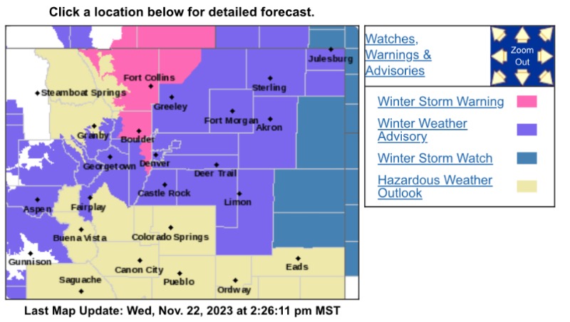
Winter Storm Warning
URGENT - WINTER WEATHER MESSAGE
National Weather Service Denver CO
159 PM MST Wed Nov 22 2023
...WINTER STORM ARRIVING THANKSGIVING EVENING...
COZ035-231200-
/O.UPG.KBOU.WS.A.0011.231123T2300Z-231124T2300Z/
/O.NEW.KBOU.WS.W.0014.231123T2300Z-231125T1200Z/
Larimer and Boulder Counties Between 6000 and 9000 Feet-
Including the cities of Estes Park, Red Feather Lakes, Nederland, and Glendevey
159 PM MST Wed Nov 22 2023
...WINTER STORM WARNING IN EFFECT FROM 4 PM THURSDAY TO 5 AM MST SATURDAY...
* WHAT...Heavy snow possible. Total snow accumulations between 6 and 14 inches expected.
* WHERE...The Northern Front Range Foothills.
* WHEN...From late Thursday afternoon through Friday afternoon.
* IMPACTS...Travel may become very difficult due to heavy snowfall on roadways, potentially impacting return travel following Thanksgiving.
PRECAUTIONARY/PREPAREDNESS ACTIONS...
Monitor the latest forecasts for updates on this situation.
Persons should consider delaying travel. If traveling, drive with extreme caution. Consider taking a winter storm kit along with you, including such items as tire chains, booster cables, flashlight, shovel, blankets and extra clothing. Also take water, a first aid kit, and anything else that would help you survive in case you become stranded.
_____________________
Winter Weather Advisory
URGENT - WINTER WEATHER MESSAGE
National Weather Service Denver CO
159 PM MST Wed Nov 22 2023
...WINTER STORM ARRIVING THANKSGIVING EVENING...
COZ036-040>051-231200-
/O.NEW.KBOU.WW.Y.0035.231124T0300Z-231125T1200Z/
Jefferson and West Douglas Counties Above 6000 Feet/Gilpin/Clear Creek/Northeast Park Counties Below 9000 Feet-North Douglas County Below 6000 Feet/Denver/West Adams and Arapahoe Counties/East Broomfield County-Elbert/Central and East Douglas Counties Above 6000 Feet-Northeast Weld County-Central and South Weld County-Morgan County-Central and East Adams and Arapahoe Counties-North and Northeast Elbert County Below 6000 Feet/North Lincoln County-Southeast Elbert County Below 6000 Feet/South Lincoln County-Logan County-Washington County-Sedgwick County-Phillips County-
Including the cities of Roggen, Agate, Amherst, Fondis, Bennett, Leader, Haxtun, Stoneham, Castle Rock, Forder, Matheson, Merino, Hugo, City of Denver, Akron, Pawnee Buttes, Kutch, Otis, Peetz, Karval, Deer Trail, Kiowa, Westcreek, Evergreen, Aurora, Georgetown, Littleton, Greeley, Sedgwick, Brush, Bailey, Brighton, Parker, Goodrich, Eaton, Wiggins, Fort Lupton, Last Chance, Limon, Larkspur, Idaho Springs, Raymer, Elbert, Crook, Julesburg, Central City, Denver International Airport, Highlands Ranch, Sterling, Ovid, Holyoke, Grover, Briggsdale, Punkin Center, Fort Morgan, Byers, and Cope
159 PM MST Wed Nov 22 2023
...WINTER WEATHER ADVISORY IN EFFECT FROM 8 PM THURSDAY TO 5 AM MST SATURDAY...
* WHAT...Snow expected. Total snow accumulations between 2 and 5 inches. Winds gusting as high as 35 mph.
* WHERE...Portions of central, east central, and northeast Colorado.
* WHEN...From 8 PM Thursday to 5 AM MST Saturday.
* IMPACTS...Roads will likely become slick and hazardous. The hazardous conditions will impact the Friday morning and evening commutes.
PRECAUTIONARY/PREPAREDNESS ACTIONS...
Roads will be slick resulting in slow and hazardous travel. Allow extra time to reach your destination.
————————————
URGENT - WINTER WEATHER MESSAGE
National Weather Service Denver CO
159 PM MST Wed Nov 22 2023
...WINTER STORM ARRIVING THANKSGIVING EVENING...
COZ034-231200-
/O.NEW.KBOU.WW.Y.0035.231124T0700Z-231125T1900Z/
South and Southeast Grand/West Central and Southwest Boulder/Gilpin/Clear Creek/Summit/North and West Park Counties Above 9000 Feet-
Including the cities of Kenosha Mountains, Berthoud Pass, Breckenridge, Williams Fork Mountains, Winter Park, East Slopes Southern Gore Range, East Slopes Mosquito Range, Indian Peaks, Mount Blue Sky, and Eisenhower Tunnel
159 PM MST Wed Nov 22 2023
...WINTER WEATHER ADVISORY IN EFFECT FROM MIDNIGHT THURSDAY NIGHT TO NOON MST SATURDAY...
* WHAT...Snow expected. Total snow accumulations between 3 and 7 inches, heaviest east of the Continental Divide.
* WHERE...The Mountains of Summit County, the Mosquito Range, and the Indian Peaks.
* WHEN...From midnight Thursday Night to noon MST Saturday.
* IMPACTS...Roads will likely become slick and hazardous. The hazardous conditions could impact the Friday morning and evening commutes.
PRECAUTIONARY/PREPAREDNESS ACTIONS...
Slow down and use caution while traveling. The latest road conditions for Colorado can be obtained by calling 5 1 1 or by going to
www.cotrip.org
.
Roads will be slick resulting in slow and hazardous travel. Allow extra time to reach your destination.
For more information from the National Weather Service, visit
weather.gov/bou