URGENT - FIRE WEATHER MESSAGE
National Weather Service Denver/Boulder CO
132 PM MDT Sun Oct 19 2025
COZ216-239>241-245>247-249-200345-
/O.UPG.KBOU.FW.A.0015.251020T1700Z-251021T0000Z/
/O.NEW.KBOU.FW.W.0026.251020T1700Z-251021T0000Z/
Jefferson and West Douglas Counties Above 6000 Feet/Gilpin/Clear Creek/Northeast Park Counties Below 9000 Feet-Boulder And Jefferson Counties Below 6000 Feet/West Broomfield County-North Douglas County Below 6000 Feet/Denver/West Adams and Arapahoe Counties/East Broomfield County-Elbert/Central and East Douglas Counties Above 6000 Feet-Central and East Adams and Arapahoe Counties-North and Northeast Elbert County Below 6000 Feet/North Lincoln County-Southeast Elbert County Below 6000 Feet/South Lincoln County-Washington County-
132 PM MDT Sun Oct 19 2025
...
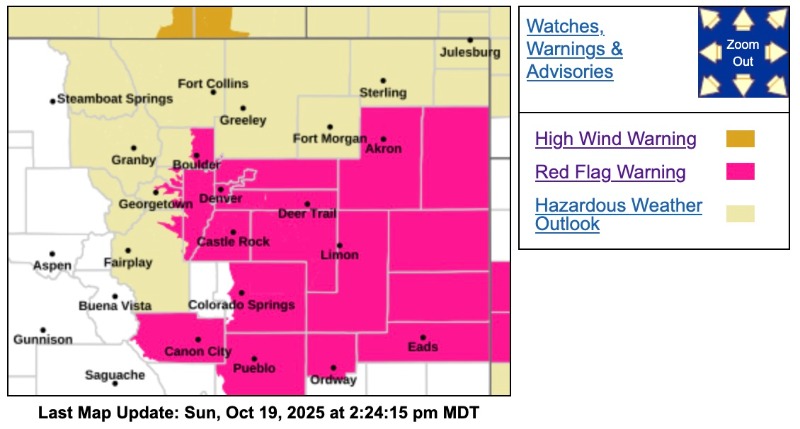
RED FLAG WARNING IN EFFECT FROM 11 AM TO 6 PM MDT MONDAY FOR WIND AND LOW RELATIVE HUMIDITY FOR THE SOUTHERN FOOTHILLS, THE DENVER METRO AREA, DOUGLAS, ELBERT, AND LINCOLN COUNTIES...
The National Weather Service in Denver has issued a Red Flag Warning for wind and low relative humidity, which is in effect from 11 AM to 6 PM MDT Monday. The Fire Weather Watch is no longer in effect.
* AFFECTED AREA...Fire Weather Zones 216, 239, 240, 241, 245, 246, 247 and 249.
* TIMING...From 11 AM to 6 PM MDT Monday.
* WINDS...Northwest 25 to 35 mph with gusts up to 50 mph.
* RELATIVE HUMIDITY...As low as 15 percent.
* IMPACTS...Conditions will be favorable for rapid fire spread. Avoid outdoor burning and any activity that may produce a spark and start a wildfire.
PRECAUTIONARY/PREPAREDNESS ACTIONS...
A Red Flag Warning means that critical fire weather conditions are either occurring now....or will shortly. A combination of strong winds...low relative humidity...and warm temperatures can contribute to extreme fire behavior.