URGENT - FIRE WEATHER MESSAGE
National Weather Service Denver/Boulder CO
721 AM MST Thu Nov 6 2025
COZ238-239-062230-
/O.NEW.KBOU.FW.W.0027.251106T1421Z-251107T0000Z/
Larimer County Below 6000 Feet/Northwest Weld County-Boulder And Jefferson Counties Below 6000 Feet/West Broomfield County-
721 AM MST Thu Nov 6 2025
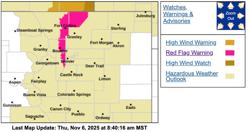
...RED FLAG WARNING IN EFFECT UNTIL 5 PM MST THIS AFTERNOON FOR WIND AND LOW RELATIVE HUMIDITY FOR THE URBAN CORRIDOR WEST OF I-25...
The National Weather Service in Denver has issued a Red Flag Warning for wind and low relative humidity, which is in effect until 5 PM MST this afternoon.
* AFFECTED AREA...Fire Weather Zones 238 and 239.
* TIMING...Until 5 PM MST this afternoon.
* WINDS...West 25 to 35 mph with gusts up to 55 mph.
* RELATIVE HUMIDITY...As low as 14 percent.
* IMPACTS...Conditions will be favorable for rapid fire spread. Avoid outdoor burning and any activity that may produce a spark and start a wildfire.
PRECAUTIONARY/PREPAREDNESS ACTIONS...
A Red Flag Warning means that critical fire weather conditions are either occurring now....or will shortly. A combination of strong winds...low relative humidity...and warm temperatures can contribute to extreme fire behavior.
From CORE Electric:
Due to a Red Flag Warning, alternate relay settings are engaged on Thursday, Nov. 6, in south Jefferson and northwest Douglas Counties.
These settings are essential to reduce the risk of igniting vegetation or other fuels near CORE lines to keep our employees and communities safe. For more information on elevated fire weather conditions, visit the National Weather Service at
www.weather.gov/