- Posts: 9735
- Thank you received: 220
- Forum
- Life Up the Hill
- Scanner & Emergency Info, Weather Forecasts
- Red Flag Warning, High Wind Warning December 17-18, 2025
Red Flag Warning, High Wind Warning December 17-18, 2025
- MountainTownAlerts
-
 Topic Author
- Mountain Legend
-

Less
More
16 Dec 2025 12:04 #1
by MountainTownAlerts
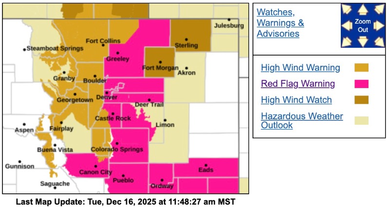
Red Flag Warning
URGENT - FIRE WEATHER MESSAGE
National Weather Service Denver/Boulder CO
306 AM MST Tue Dec 16 2025
COZ238>240-242-243-245-162200-
/O.UPG.KBOU.FW.A.0016.251217T1800Z-251218T0100Z/
/O.NEW.KBOU.FW.W.0029.251217T1800Z-251218T0100Z/
Larimer County Below 6000 Feet/Northwest Weld County-Boulder And Jefferson Counties Below 6000 Feet/West Broomfield County-North Douglas County Below 6000 Feet/Denver/West Adams and Arapahoe Counties/East Broomfield County-Northeast Weld County-Central and South Weld County-Central and East Adams and Arapahoe Counties-
306 AM MST Tue Dec 16 2025
...RED FLAG WARNING IN EFFECT FROM 11 AM TO 6 PM MST WEDNESDAY FOR WIND AND LOW RELATIVE HUMIDITY FOR THE URBAN CORRIDOR...
The National Weather Service in Denver has issued a Red Flag Warning for wind and low relative humidity, which is in effect from 11 AM to 6 PM MST Wednesday. The Fire Weather Watch is no longer in effect.
* AFFECTED AREA...Fire Weather Zones 238, 239, 240, 242, 243 and 245.
* TIMING...From 11 AM to 6 PM MST Wednesday.
* WINDS...West 20 to 40 mph with gusts 60 to 80 mph.
* RELATIVE HUMIDITY...15 to 25 percent.
* IMPACTS...Conditions will be favorable for rapid fire spread. Avoid outdoor burning and any activity that may produce a spark and start a wildfire.
PRECAUTIONARY/PREPAREDNESS ACTIONS...
A Red Flag Warning means that critical fire weather conditions are either occurring now....or will shortly. A combination of strong winds...low relative humidity...and warm temperatures can contribute to extreme fire behavior.
_ _ _ _ _ _ _ _ _ _
High Wind Warning
URGENT - WEATHER MESSAGE
National Weather Service Denver CO
151 AM MST Tue Dec 16 2025
COZ035-036-038-039-162200-
/O.UPG.KBOU.HW.A.0006.251217T1800Z-251218T0700Z/
/O.NEW.KBOU.HW.W.0009.251217T1800Z-251218T0700Z/
Larimer and Boulder Counties Between 6000 and 9000 Feet-Jefferson and West Douglas Counties Above 6000 Feet/Gilpin/Clear Creek/Northeast Park Counties Below 9000 Feet-Larimer County Below 6000 Feet/Northwest Weld County-Boulder And Jefferson Counties Below 6000 Feet/West Broomfield County-Including the cities of Glendevey, Golden, Central City, Nederland, Lakewood, Georgetown, Longmont, Evergreen, Estes Park, Hereford, Boulder, Bailey, Red Feather Lakes, Arvada, Loveland, Idaho Springs, Westcreek, Nunn, and Fort Collins
151 AM MST Tue Dec 16 2025
...HIGH WIND WARNING IN EFFECT FROM 11 AM WEDNESDAY TO MIDNIGHT MST WEDNESDAY NIGHT...
* WHAT...West winds 30 to 40 mph with gusts 65 to 85 mph expected.
* WHERE...The Northern Front Range Foothills, The Southern Front Range Foothills, Fort Collins, Longmont, Boulder and the western suburbs of Denver. Strongest winds will be west of I-25 and north of I-70.
* WHEN...From 11 AM Wednesday to midnight MST Wednesday Night. Strongest winds expected Wednesday afternoon.
* IMPACTS...Damaging winds will blow down trees and power lines. Widespread power outages are expected. Travel will be difficult, especially for high profile vehicles. Strong winds will likely lead to rapid fire growth of any new fire.
PRECAUTIONARY/PREPAREDNESS ACTIONS...
People are urged to secure loose objects that could be blown around or damaged by the wind.
Winds this strong can make driving difficult, especially for high profile vehicles. Use extra caution.
Avoid outdoor burning or any activity that may cause sparks. The strong winds will likely fuel rapid fire growth.
High Wind Warning
URGENT - WEATHER MESSAGE
National Weather Service Denver CO
151 AM MST Tue Dec 16 2025
COZ033-034-162200-
/O.UPG.KBOU.HW.A.0006.251217T1800Z-251218T0700Z/
/O.NEW.KBOU.HW.W.0009.251217T1800Z-251218T1200Z/
South and East Jackson/Larimer/North and Northeast Grand/Northwest Boulder Counties Above 9000 Feet-South and Southeast Grand/West Central and Southwest Boulder/Gilpin/Clear Creek/Summit/North and West Park Counties Above 9000 Feet-Including the cities of Rabbit Ears Range, Willow Creek Pass, Indian Peaks, Eisenhower Tunnel, East Slopes Mosquito Range, Rocky Mountain National Park, Williams Fork Mountains, Breckenridge, Mount Blue Sky, Winter Park, East Slopes Southern Gore Range, Kenosha Mountains, Laramie and Medicine Bow Mountains, Cameron Pass, and Berthoud Pass
151 AM MST Tue Dec 16 2025
...HIGH WIND WARNING IN EFFECT FROM 11 AM WEDNESDAY TO 5 AM MST THURSDAY...
* WHAT...West winds 30 to 40 mph with gusts up to 80 mph expected.
* WHERE...Rocky Mountain National Park and the Medicine Bow Range, and The Mountains of Summit County, the Mosquito Range, and the Indian Peaks.
* WHEN...From 11 AM Wednesday to 5 AM MST Thursday. Strongest winds expected Wednesday evening through Wednesday night.
* IMPACTS...Damaging winds may blow down trees and power lines, with power outages possible. Travel will be difficult, especially for high profile vehicles.
PRECAUTIONARY/PREPAREDNESS ACTIONS...
People are urged to secure loose objects that could be blown around or damaged by the wind.
Please Log in or Create an account to join the conversation.
- MountainTownAlerts
-
Topic Author
- Mountain Legend
-
Less
More
- Posts: 9735
- Thank you received: 220
16 Dec 2025 12:07 #2
by MountainTownAlerts
Replied by MountainTownAlerts on topic Red Flag Warning, High Wind Warning December 17-18, 2025
Public Safety Power Shutoff likely as we prepare for high winds and dry conditions in Colorado on Wednesday, Dec. 17.
- XCel Energy Colorado
Page Updated: 9 a.m., MT, Tuesday, Dec. 16, 2025
Current Situation
We continue to prepare for a strong wind event and likely Public Safety Power Shutoff (PSPS) in Colorado forecast to start Wednesday, Dec. 17.
The National Weather Service has issued a Red Flag Warning for this weather event. Wildfire risk is expected to increase, and strong winds heighten risk of damage to our power lines and may result in outages.
To reduce the risk of wildfire and support public safety, we are planning for a likely PSPS beginning on Wednesday, Dec. 17, around 12 noon, impacting customers in Adams, Arapahoe, Boulder, Broomfield, Denver, Douglas, Jefferson, Larimer and Weld counties. Weather conditions are expected to start improving around 6 p.m. Wednesday.
Restoring outages from a significant weather event or Public Safety Power Shutoff may take several hours to several days. This is because crews must inspect lines and repair damage before lines can be safely re-energized.
The impacted areas and number of customers affected may continue to change as weather conditions evolve and our teams refine the scope of the PSPS event. We expect to share an update on impacted areas and customers this afternoon, and to make an affirmative decision about whether a PSPS is required no later than tomorrow morning.
Customers in Adams, Arapahoe, Boulder, Broomfield, Denver, Douglas, Jefferson, Larimer and Weld counties can look up their address on our outage map to find out if they may be affected by this PSPS event. Please note, due to anticipated high winds, outages could take place outside of areas impacted by the PSPS, impacting restoration times.
Enhanced Powerline Safety Settings (EPSS) will also be activated along the Front Range. This means power lines are more sensitive and can stop the flow of electricity if an issue, like a tree branch touching the line, is detected. This helps improve public safety during heightened risk conditions. When these settings are enabled, crews must inspect lines and repair damage before they can be safely re-energized.
Xcel Energy will attempt to contact potentially affected customers via phone call, email and text message as the forecasted weather event approaches, and we will update customers throughout the weather event with outage and restoration information.
We encourage customers to plan for potential power outages later this week due to weather, especially those who have medical equipment that relies on electricity. More tips for how to prepare for an outage are available on our website.
To help ensure you receive timely updates, please make sure your communications preferences are up to date by logging on to My Account.
Please know the forecast may change and we will provide updates as needed.
We plan to share a further update about the potential for a PSPS event the afternoon of Tuesday, Dec. 16.
Please Log in or Create an account to join the conversation.
- MountainTownAlerts
-
Topic Author
- Mountain Legend
-
Less
More
- Posts: 9735
- Thank you received: 220
16 Dec 2025 21:52 #3
by MountainTownAlerts
Replied by MountainTownAlerts on topic Red Flag Warning, High Wind Warning December 17-18, 2025
Update from XCel Energy:
Our top priority is ensuring the safety of our communities, customers, and crews as we prepare for tomorrow’s forecasted extreme weather, including conducting a targeted Public Safety Power Shutoff (PSPS) starting at 10 am, December 17, potentially impacting about 50,000 customers in Boulder, Clear Creek, Jefferson, Larimer and Weld counties. Weather conditions necessitating a PSPS are expected to start improving around 6 p.m. Wednesday, though high winds that may create wildfire risk and cause outages are expected to continue through Friday.
To find out whether your address is affected by the public safety power shutoff, visit co.my.xcelenergy.com/s/outage-safety/outage-map
We also stress that those who are not expected to be part of the PSPS may still experience outages due to the high winds associated with this dangerous weather event.
For more information on how to prepare, visit co.my.xcelenergy.com/s/outage-safety/wildfires
As always, our crews will work as quickly as they can to restore power in the event of a PSPS or other weather-related outages.
We conduct risk assessments based on the latest forecast data and advanced modeling tool outputs, as well as recent improvements to grid infrastructure, which have enabled us to reduce the size of the affected areas for a Public Safety Power Shutoff [PSPS] on Wednesday. As a result, the number of potentially impacted customers has been reduced significantly from original estimates, to about 50,000.
Our goal is to limit the impact of a PSPS event as much as possible while effectively managing high wildfire risk due to low humidity, dry vegetation, and very high winds.
To see if your address will be impacted by the PSPS, visit co.my.xcelenergy.com/s/outage-safety/wildfires
Please Log in or Create an account to join the conversation.
- MountainTownAlerts
-
Topic Author
- Mountain Legend
-
Less
More
- Posts: 9735
- Thank you received: 220
16 Dec 2025 22:41 #4
by MountainTownAlerts
Replied by MountainTownAlerts on topic Red Flag Warning, High Wind Warning December 17-18, 2025
From CORE Electric Cooperative:
We are closely monitoring a forecasted high wind event expected to begin along the Front Range around noon on Wednesday, December 17. CORE is not planning any Public Safety Power Shutoff (PSPS) events. Our risk criteria have determined a PSPS is not necessary in our service territory.
However, as a safety precaution, we will implement alternate relay settings in some areas. These settings help prevent wildfire risk by de-energizing lines when a fault—such as a branch or tree contacting the line—is detected. The line will remain off until crews confirm the fault no longer poses a fire risk.
Because these settings shut off the line from the substation, members may experience broader outages instead of brief blinks during this time.
Members in the Bergen Park area may be affected by an Xcel Energy planned PSPS due to a transmission line owned and operated by that utility. Those members have been contacted directly.
We encourage all members to be prepared for outages during high wind weather events, especially those with medical needs. Please:
Keep an outage kit ready
Operate generators safely
Make alternative arrangements if you cannot go without power for an extended period of time
For real-time updates, visit CORE.coop/outage-center .
Please Log in or Create an account to join the conversation.
- Forum
- Life Up the Hill
- Scanner & Emergency Info, Weather Forecasts
- Red Flag Warning, High Wind Warning December 17-18, 2025
Time to create page: 0.175 seconds
sponsors


