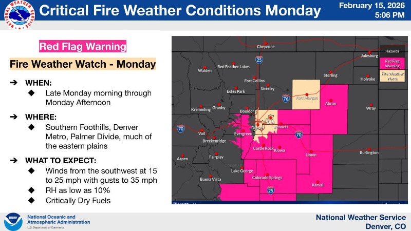
Elevated to critical fire weather conditions expected on Monday for the southern foothills, southern I-25 corridor and much of the eastern plains. Relative humidity values will be as low as 10% with wind gusts up to 35 mph. A Red Flag Warning is in effect from 11 AM to 6 PM.
URGENT - FIRE WEATHER MESSAGE
National Weather Service Denver/Boulder CO
514 PM MST Sun Feb 15 2026
...PROLONGED PERIOD OF CRITICAL FIRE WEATHER CONDITIONS THROUGH AT
LEAST TUESDAY...
...EXTREMELY CRITICAL FIRE WEATHER CONDITIONS REMAIN POSSIBLE
TUESDAY...
.Recent dry conditions combining with above normal temperatures
and periods of gusty winds will bring potentially critical fire
weather conditions again on Monday. Stronger, more widespread
westerly winds are expected to develop Tuesday, possibly producing
extremely critical fire weather conditions with wind gusts as
high as 65 mph across the plains.
COZ216-241-245-247-160815-
/O.CON.KBOU.FW.W.0010.260216T1800Z-260217T0100Z/
/O.CON.KBOU.FW.A.0009.260217T1700Z-260218T0300Z/
Jefferson and West Douglas Counties Above 6000 Feet/Gilpin/Clear Creek/Northeast Park Counties Below 9000 Feet-Elbert/Central and East Douglas Counties Above 6000 Feet-Central and East Adams and Arapahoe Counties-Southeast Elbert County Below 6000 Feet/South Lincoln County-
514 PM MST Sun Feb 15 2026
...
RED FLAG WARNING REMAINS IN EFFECT FROM 11 AM TO 6 PM MST MONDAY FOR WIND AND LOW RELATIVE HUMIDITY FOR THE SOUTHERN FRONT RANGE FOOTHILLS, PALMER DIVIDE, AND ADJACENT PLAINS TO THE EAST...
...
FIRE WEATHER WATCH REMAINS IN EFFECT FROM TUESDAY MORNING THROUGH TUESDAY EVENING FOR WIND AND LOW RELATIVE HUMIDITY FOR THE SOUTHERN FRONT RANGE FOOTHILLS, PALMER DIVIDE, AND ADJACENT PLAINS TO THE EAST...
* AFFECTED AREA...Fire Weather Zones 216, 241, 245 and 247.
* TIMING...For the Red Flag Warning, from 11 AM to 6 PM MST Monday. For the Fire Weather Watch, from Tuesday morning through Tuesday evening.
* WINDS...Southwest winds 15 to 25 mph with gusts to 35 mph on Monday, with a few gusts up to 50 mph possible across the far southern Foothills. West 30 to 40 mph with gusts up to 65 mph on Tuesday.
* RELATIVE HUMIDITY...As low as 10 percent.
* IMPACTS...Conditions will be favorable for rapid fire spread. Avoid outdoor burning and any activity that may produce a spark and start a wildfire.
PRECAUTIONARY/PREPAREDNESS ACTIONS...
A Red Flag Warning means that critical fire weather conditions are either occurring now....or will shortly. A combination of strong winds...low relative humidity...and warm temperatures can contribute to extreme fire behavior.
A Fire Weather Watch means that critical fire weather conditions are forecast to occur. Listen for later forecasts and possible Red Flag Warnings.