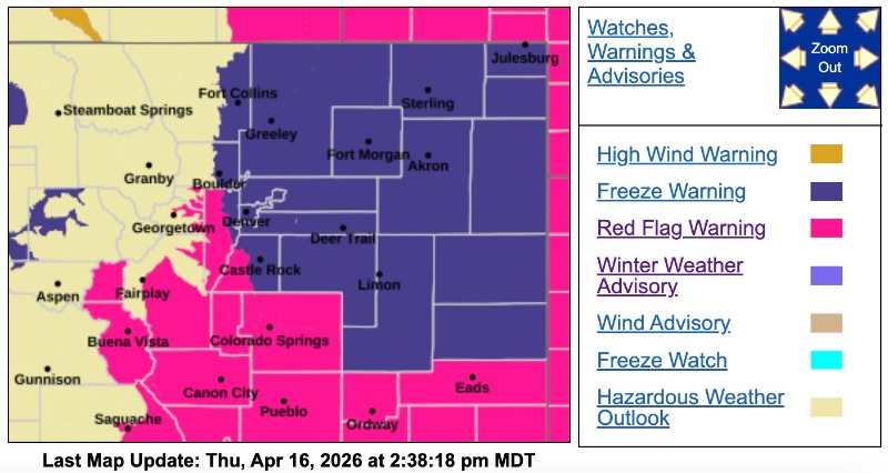
Red Flag Warning
URGENT - FIRE WEATHER MESSAGE
National Weather Service Denver/Boulder CO
1233 PM MDT Thu Apr 16 2026
COZ214-216-241-245>247-249-170300-
/O.CON.KBOU.FW.W.0035.000000T0000Z-260417T0300Z/
Central and Southeast Park County-Jefferson and West Douglas Counties Above 6000 Feet/Gilpin/Clear Creek/Northeast Park Counties Below 9000 Feet-Elbert/Central and East Douglas Counties Above 6000 Feet-Central and East Adams and Arapahoe Counties-North and Northeast Elbert County Below 6000 Feet/North Lincoln County-Southeast Elbert County Below 6000 Feet/South Lincoln County-Washington County-
1233 PM MDT Thu Apr 16 2026
...
RED FLAG WARNING REMAINS IN EFFECT UNTIL 9 PM MDT THIS EVENING FOR WIND AND LOW RELATIVE HUMIDITY FOR SOUTH PARK, THE SOUTHERN FRONT RANGE FOOTHILLS, PALMER DIVIDE, AND ADJACENT PLAINS SOUTH OF I-76...
* AFFECTED AREA...Fire Weather Zones 214, 216, 241, 245, 246, 247 and 249.
* TIMING...Until 9 PM MDT this evening.
* WINDS...Southwest 15 to 25 mph with gusts up to 35 mph.
* RELATIVE HUMIDITY...As low as 8 percent.
* IMPACTS...Conditions will be favorable for rapid fire spread. Avoid outdoor burning and any activity that may produce a spark and start a wildfire.
PRECAUTIONARY/PREPAREDNESS ACTIONS...
A Red Flag Warning means that critical fire weather conditions are either occurring now....or will shortly. A combination of strong winds...low relative humidity...and warm temperatures can contribute to extreme fire behavior.
_ _ _ _ _ _
Freeze Warning
URGENT - WEATHER MESSAGE
National Weather Service Denver CO
1102 AM MDT Thu Apr 16 2026
COZ038>051-170115-
/O.UPG.KBOU.FZ.A.0001.260418T0200Z-260418T1400Z/
/O.NEW.KBOU.FZ.W.0001.260418T0200Z-260418T1400Z/
Larimer County Below 6000 Feet/Northwest Weld County-Boulder And
Jefferson Counties Below 6000 Feet/West Broomfield County-North Douglas County Below 6000 Feet/Denver/West Adams and Arapahoe Counties/East Broomfield County-Elbert/Central and East Douglas Counties Above 6000 Feet-Northeast Weld County-Central and South Weld County-Morgan County-Central and East Adams and Arapahoe Counties-North and Northeast Elbert County Below 6000 Feet/North Lincoln County-Southeast Elbert County Below 6000 Feet/South Lincoln County-Logan County-Washington County-Sedgwick County-Phillips County-
Including the cities of Lakewood, Littleton, Castle Rock, Larkspur, Bennett, Merino, Sterling, Crook, Elbert, Goodrich, Punkin Center, Fort Collins, Hugo, Longmont, Eaton, Ovid, Cope, City of Denver, Briggsdale, Raymer, Deer Trail, Parker, Matheson, Kiowa, Highlands Ranch, Stoneham, Boulder, Leader, Aurora, Karval, Kutch, Limon, Grover, Fort Morgan, Roggen, Fort Lupton, Haxtun, Loveland, Hereford, Sedgwick, Greeley, Akron, Byers, Forder, Holyoke, Brighton, Last Chance, Amherst, Fondis, Agate, Otis, Nunn, Pawnee Buttes, Wiggins, Golden, Peetz, Julesburg, Brush, Arvada, and Denver International Airport
1102 AM MDT Thu Apr 16 2026
...
FREEZE WARNING IN EFFECT FROM 8 PM FRIDAY TO 8 AM MDT SATURDAY...
* WHAT...Prolonged sub-freezing temperatures dropping down into the 18 to 24 degree range.
* WHERE...All of the Front Range Urban Corridor and northeast plains of Colorado.
* WHEN...From Friday evening through Saturday morning.
* IMPACTS...If not drained or protected, damage to above ground irrigation lines will be likely. A hard freeze could kill sensitive vegetation and damage fruit trees.
PRECAUTIONARY/PREPAREDNESS ACTIONS...
Disconnect water hoses.
Drain above ground irrigation lines.
Take steps now to protect tender plants from the cold.
For more information from the National Weather Service, visit
weather.gov/bou