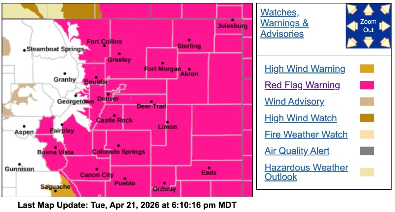
Red Flag Warning
URGENT - FIRE WEATHER MESSAGE
National Weather Service Denver/Boulder CO
115 PM MDT Tue Apr 21 2026
COZ214-216-238>251-220615-
/O.NEW.KBOU.FW.A.0028.260423T1600Z-260424T0200Z/
/O.CON.KBOU.FW.W.0037.260422T1600Z-260423T0600Z/
Central and Southeast Park County-Jefferson and West Douglas Counties Above 6000 Feet/Gilpin/Clear Creek/Northeast Park Counties Below 9000 Feet-Larimer County Below 6000 Feet/Northwest Weld County-
Boulder And Jefferson Counties Below 6000 Feet/West Broomfield County-North Douglas County Below 6000 Feet/Denver/West Adams and Arapahoe Counties/East Broomfield County-Elbert/Central and East Douglas Counties Above 6000 Feet-Northeast Weld County-Central and South Weld County-Morgan County-Central and East Adams and Arapahoe Counties-North and Northeast Elbert County Below 6000 Feet/North Lincoln County-Southeast Elbert County Below 6000 Feet/South Lincoln County-Logan County-Washington County-Sedgwick County-Phillips County-
115 PM MDT Tue Apr 21 2026
...
RED FLAG WARNING REMAINS IN EFFECT FROM 10 AM WEDNESDAY TO MIDNIGHT MDT WEDNESDAY NIGHT FOR WIND AND LOW RELATIVE HUMIDITY FOR THE FRONT RANGE FOOTHILLS, URBAN CORRIDOR, PLAINS, AND SOUTH PARK...
...FIRE WEATHER WATCH IN EFFECT FROM THURSDAY MORNING THROUGH THURSDAY EVENING FOR WIND AND LOW RELATIVE HUMIDITY FOR SOUTHERN FOOTHILLS, URBAN CORRIDOR, PLAINS, AND SOUTH PARK...
The National Weather Service in Denver has issued a Fire Weather Watch for wind and low relative humidity, which is in effect from Thursday morning through Thursday evening.
* AFFECTED AREA...Fire Weather Zones 214, 216, 238, 239, 240, 241, 242, 243, 244, 245, 246, 247, 248, 249, 250 and 251.
* TIMING...For the Red Flag Warning, from 10 AM Wednesday to midnight MDT Wednesday night. For the Fire Weather Watch, from Thursday morning through Thursday evening.
* WINDS...For the Red Flag Warning, west 20 to 30 mph with gusts up to 45 mph. For the Fire Weather Watch, northwest winds gusting up to 50 mph.
* RELATIVE HUMIDITY...For the Red Flag Warning, 5 to 8 percent. For the Fire Weather Watch, as low as 10 percent.
* IMPACTS...Conditions will be favorable for rapid fire spread. Avoid outdoor burning and any activity that may produce a spark and start a wildfire.
PRECAUTIONARY/PREPAREDNESS ACTIONS...
A Red Flag Warning means that critical fire weather conditions are either occurring now....or will shortly. A combination of strong winds...low relative humidity...and warm temperatures can contribute to extreme fire behavior.
A Fire Weather Watch means that critical fire weather conditions are forecast to occur. Listen for later forecasts and possible Red Flag Warnings.