Red Flag Warning
URGENT - FIRE WEATHER MESSAGE
National Weather Service Denver/Boulder CO
111 PM MDT Sat Jun 27 2026
...PROLONGED CRITICAL FIRE WEATHER CONDITIONS EXPECTED FOR THE HIGH COUNTRY THROUGH THE WEEKEND... POTENTIALLY CONTINUING INTO THE UPCOMING WEEK...
A warm and dry airmass will coincide with considerably stronger west and southwest winds today and Sunday, potentially continuing into early next week. Sustained winds are expected to exceed 20 to 30 mph across much of the high country this afternoon, with gusts of 40 to 50 mph, strongest for exposed areas and higher elevations. These conditions will drive very high fire danger across the warned area, that may extend through the evening hours of Saturday driven by the enhanced winds. Similar conditions are likely on Sunday. Any new starts or established fires will likely spread rapidly under these conditions.
COZ211>214-216-218-280615-
/O.UPG.KBOU.FW.A.0039.260628T1700Z-260629T0300Z/
/O.NEW.KBOU.FW.W.0049.260628T1700Z-260629T0300Z/
/O.CON.KBOU.FW.W.0048.000000T0000Z-260628T0600Z/
Jackson County Below 9000 Feet-South and Southeast Grand/West Central and Southwest Boulder/Gilpin/
Clear Creek/Summit/North and West Park Counties Above 9000 Feet-Grand and Summit Counties Below 9000 Feet-
Central and Southeast Park County-Jefferson and West Douglas Counties Above 6000 Feet/Gilpin/Clear Creek/Northeast Park Counties Below 9000 Feet-South and East Jackson/Larimer/North and Northeast Grand/Northwest Boulder Counties Above 9000 Feet-
111 PM MDT Sat Jun 27 2026
...
RED FLAG WARNING REMAINS IN EFFECT UNTIL MIDNIGHT MDT TONIGHT FOR WIND AND LOW RELATIVE HUMIDITY FOR THE MOUNTAINS AND HIGH VALLEYS...
...RED FLAG WARNING IN EFFECT FROM 11 AM TO 9 PM MDT SUNDAY FOR WIND AND LOW RELATIVE HUMIDITY FOR THE MOUNTAINS AND HIGH VALLEYS...
The National Weather Service in Denver has issued a Red Flag Warning for wind and low relative humidity, which is in effect from 11 AM to 9 PM MDT Sunday. The Fire Weather Watch is no longer in effect.
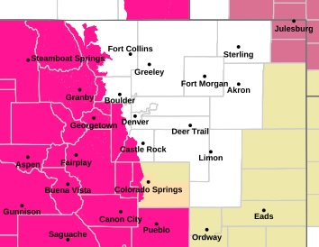
* AFFECTED AREA...Fire Weather Zones 211, 212, 213, 214, 216 and 218.
* TIMING...For the first Red Flag Warning, until midnight MDT tonight. For the second Red Flag Warning, from 11 AM to 9 PM MDT Sunday.
* WINDS...For today, southwest 20 to 30 mph with gusts up to 50 mph. For Sunday, southwest 15 to 25 mph with gusts up to 45 mph.
* RELATIVE HUMIDITY...For today, between 10 and 14 percent. For Sunday, between 10 and 15 percent.
* IMPACTS...Conditions will be favorable for rapid fire spread. Avoid outdoor burning and any activity that may produce a spark and start a wildfire.
PRECAUTIONARY/PREPAREDNESS ACTIONS...
A Red Flag Warning means that critical fire weather conditions are either occurring now....or will shortly. A combination of strong winds...low relative humidity...and warm temperatures can contribute to extreme fire behavior.