- Forum
- Life Up the Hill
- Community News, Events, and Calendar
- Sept 8: RED ROCKS EXTREME CHALLENGE - CYCLE TO CONQUER ALS
Sept 8: RED ROCKS EXTREME CHALLENGE - CYCLE TO CONQUER ALS
- Mountain-News-Events
-
 Topic Author
- Mountain Legend
-

www.deathridetour.com/red-rocks-challenge/about-the-ride/As you may know, Colorado is one of the most beautiful states in the US and the Front Range is spectacular when it comes to cycling. Places like Red Rocks Park and Dinosaur Ridge are breath taking. Climbs up High Drive and City View will certainly test your endurance and strength. The RED ROCKS EXTREME Challenge has been previously named the Healing Wheels Ride, the Red Rocks Century and the Red Rocks Gran Fondo. In 2017, the event became part of the 501c3 Non- Profit, DEATH RIDE Tour Inc., Charity Cycling Events ...CYCLE TO CONQUER ALS …For Those Who Care, Tax ID 27-1823372. We proud to say that since its inception in 2009 our charity has been able to donate back over $300,000 to worthwhile ALS Charites. We thank all our participants, our sponsors and our contributors for their amazing support.
Each participant is required to raise $300 in donations by ride day, September 8th. All proceeds of the event will be donated to support ALS Research.
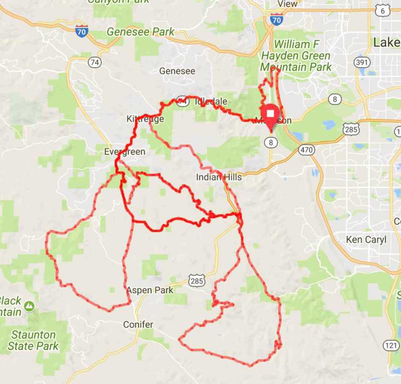
32 Mile Route
ridewithgps.com/routes/23230834
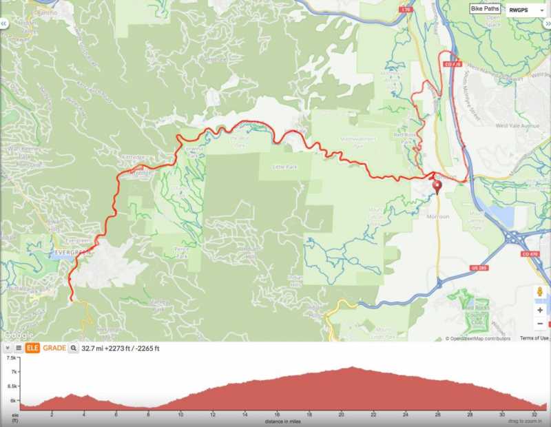
This 32-mile route will start at T.E.V. Edelweiss like all the others and you’ll warm up with gentle climbs in beautiful Red Rocks Park in the early morning light, exiting though Dinosaur Ridge back to Morrison. From there you’ll head up a gentle grade on Bear Creek Rd to Evergreen. Along the way, you’ll hit Aid Station 1 at the Kittredge Community Bible Church if you need it. When you get to Evergreen (at the lake) you’ll be making a left on Hwy 73 to Aid Station 2. This is where you’ll turn around and head back the way you came. Up Hwy 73 then a right turn onto Hwy 74 back into Morrison turning right at Hwy 8 to T.E.V. Edelweiss.
51 Mile Route
ridewithgps.com/routes/22931450
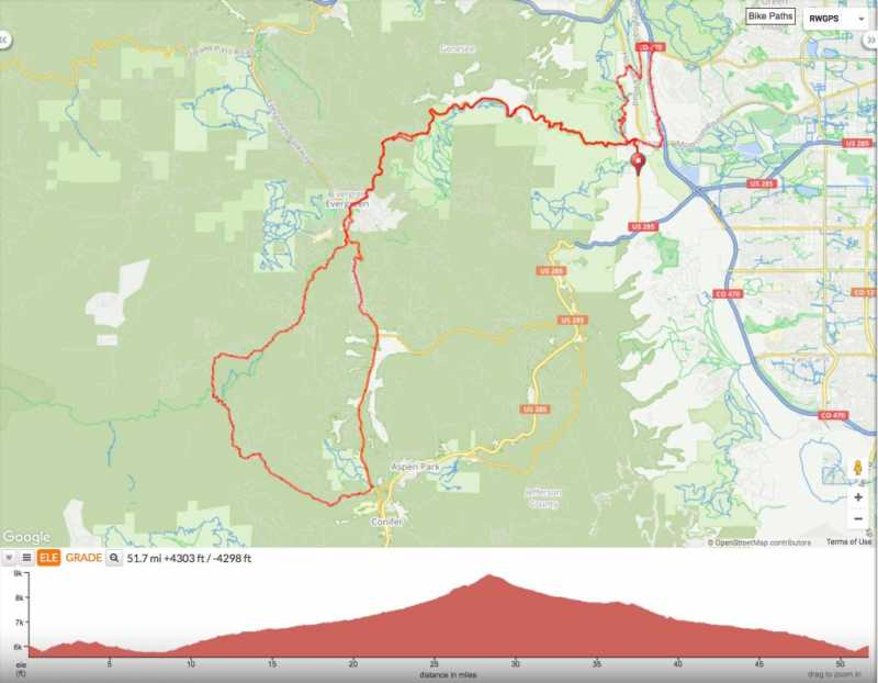
The 51-mile route takes you the same way as the 32 route above, however, you continue passed Aid Station 2 turning right on Brook Forest Rd. You will continue up Brook Forest Rd a couple of miles before hitting the first major climb. Riders will climb for about 5 miles on Brook Forest Rd, ending at the peak of Brook Forest and celebrating their climb at Aid Station 3.
From the Aid Station, you’ll have a nice decent until you get to Hwy 73. Take a left turn on 73 and proceed north until you get to the junction of Hwy 73 & North Turkey Creek. Look for Aid Station 4 at Aspen Ridge Church after turning left at North Turkey Creek. This is the bail on spot for the 51 miler riders. After the rest stop you’ll continue around the traffic circle to Hwy 73 North back to Evergreen Lake turning right on to Hwy 74 and back into Morrison. If needed you’ll find Aid Station 1 on the left of the highway at the Kittredge Community Bible Church. Continue Hwy 74 to Hwy 8 in Morrison and turn right back to T.E.V Edelweiss.
60 Mile Metric Century Route
ridewithgps.com/routes/24398734
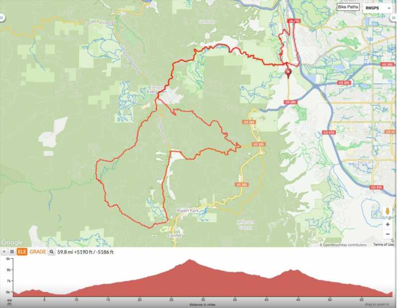
This route takes you the same way as the route above, however, at Aid Station 4 Aspen Ridge Church you will continue east on North Turkey Creek Rd for about 5 miles until you get to High Drive where you’ll make a left. Here you’ll face your major climb of the day up High Drive for about 4 miles. At the top, you’ll find another rest stop, Aid Station 5. After the Aid station, you’ll descend Stanley Park Rd to Little Cub back to Hwy 74 turning right towards Morrison. If needed you’ll find Aid Station 1 on the left of the highway at the Kittredge Community Bible Church. Continue Hwy 74 to Hwy 8 in Morrison and turn right back to T.E.V Edelweiss.
The “BEAST” – 130 Miles & 13,000 Feet of Climbing
ridewithgps.com/routes/26583060
This is exactly what the name says – a “BEAST” of a ride. You start off with the same course as the Metric Century with climbs up Brook Forest Road and High Drive. You’ll descend Stanley Park and Little Club going back to Hwy 73 South back to S Turkey Creek and Aid Station 4 at Aspen Ridge Church. After the stop, you’re heading back east on S Turkey Creek going under Hwy 285. Continue S Turkey Creek to the junction of S Turkey Creek & Deer Creek Canyon. Stay to the right, continue S Turkey Creek until you get to Hillsdale turn right then a quick left onto City View – here’s your 3rd major climb. Climb City View until it turns into Crystal Drive. Crystal Drive to Oehlmann Park Rd. Oehlmann Park Rd to Pheasant Park Road where you’ll find Aid Station 6. After this Aid Station, you have a very nice descent down High Range until you get to Deer Creek Canyon where you make a left with a couple mile climb again for climb number 4. After the climb, you’ll descend Deer Creek Canyon back to S. Turkey Road make a right and back to under Hwy 285. Be on the lookout for High Drive again where you’ll make a right and do this climb number 5 for a second time. There will be Aid Station 4 at the top of High Drive waiting for you. You’ll then descend Stanley Park to Little Cub back to Hwy 73 to Hwy 74 turn right and head back towards Morrison.
In Kittredge, you’ll turn right at Myers Gulch taking that south toward Parmalee Gulch to S Turkey Creek – south to N Turkey Creek back to Hwy 73 North. Hwy. Hwy 73 North to Hwy 74 turn right and back to Morrison turning right at Hwy 8 to T.E.V. Edelweiss and the FINISH THE BEAT CELEBRATION where you will receive your FINISHER BEAST JERSY AND BELT BUCKLE.
My Mountain Town Community Calendar - filter events by Category, date, or keyword to easily find events of interest. Add your community, church, or non-profit event to the calendar yourself! Click here to access the submission form. Businesses: please contact us for more information on adding your events! Questions? Email
Community News, Events, and Calendar Forum - Check here for the latest happenings in our community and add your own!
Please Log in or Create an account to join the conversation.
- Mountain-News-Events
-
Topic Author
- Mountain Legend
-
www.bicyclecolorado.org/ride-colorado/rules-of-the-road/
For your information only on types of races, permits, and coordination with CDOT/CSP.
CDOT: Special Event Permits and Information
Special Events on Colorado State Highways
My Mountain Town Community Calendar - filter events by Category, date, or keyword to easily find events of interest. Add your community, church, or non-profit event to the calendar yourself! Click here to access the submission form. Businesses: please contact us for more information on adding your events! Questions? Email
Community News, Events, and Calendar Forum - Check here for the latest happenings in our community and add your own!
Please Log in or Create an account to join the conversation.
- Forum
- Life Up the Hill
- Community News, Events, and Calendar
- Sept 8: RED ROCKS EXTREME CHALLENGE - CYCLE TO CONQUER ALS