Although I was pretty young when it happened, this event left an impression on me. I became fascinated with volcanoes and for a time wanted to become a volcanologist. They intrigue me still to this day.
Soapbox: Back then, as now, heed scientists. No they aren't perfect, but they have in-depth knowledge, and for the most part go into that field to help better humankind and the planet, not to get rich or wield power. /off soapbox
WA Emergency Management @waEMD May 13, 2020
40 years ago today, people pushed the state to reopen areas around Mt. St. Helens citing tourism & the economy against advice of scientists. Five days later, the volcano erupted. #msh40
Tweet
USGS Volcanoes @USGSVolcanoes May 13, 2020
#40YearsAgo at #MountStHelens: Officials meet. Scientists think it's to close areas, but discussion turns to opening access. Blind-sided, they point to hazard map & say red/blue zones don’t acknowledge miles of real hazards. But plan moves forward to reconsider boundaries. #MSH40
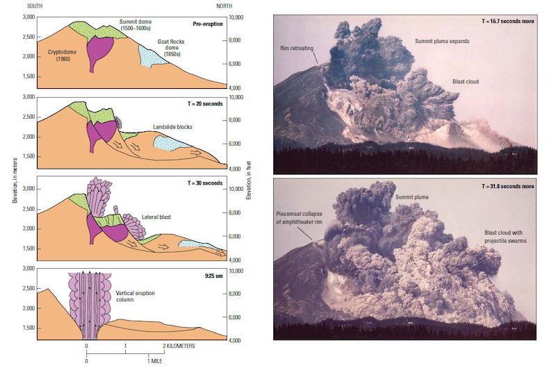
#40YearsAgo at #MountStHelens: 8:30 AM Spokane geologists on once-in-a-lifetime flight to see volcano. Circling, a mile-long E-W fracture pops open just north of the crater. Mass vibrates, ripples, churns, sinks. Pilot opens throttle, dives to gain speed, lands at PDX. #MSH40
#40YearsAgo at #MountStHelens: 8:32 AM “Vancouver! Vancouver! This is it!” radios USGS’ David Johnston from Coldwater II, 1300 ft above N Fork Toutle River & 5.5 mi N-NW of volcano. Vancouver doesn't hear warning; message heard/recorded by Ham radio operator. #MSH40
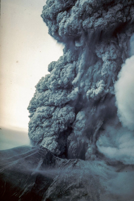
#40YearsAgo at #MountStHelens: 8:35 AM Gary Rosenquist & friends camp near Bear Meadow. Ground shakes, mtn sliding. He dashes to tripod, grabs at camera & accidentally turns it slightly right centering the eruption cloud. Photos helps scientists understand early events. #MSH40
#40YearsAgo at #MountStHelens: 9:20 AM Seismograph goes wild. Reports of eruption. No response from Johnston. From plane, Don Swanson watches roiling, twisting helix. Clouds pull back enough to see column jets from great hole. Swanson radios—the top of the mountain’s gone! #MSH40
This documentary that aired on A&E was fantastic.
"Now, more than ever, the illusions of division threaten our very existence. We all know the truth: more connects us than separates us. But in times of crisis the wise build bridges, while the foolish build barriers. We must find a way to look after one another as if we were one single tribe.” -King T'Challa, Black Panther
The truth is incontrovertible. Malice may attack it. ignorance may deride it, but in the end, there it is. ~Winston Churchill
Attachments:
Last edit: 18 May 2020 12:01 by ScienceChic. Reason: fixed twitter links that weren't displaying