- Posts: 103
- Thank you received: 4
Park County – This is Your Colorado
- 285Tourism
-
 Topic Author
- Mountain Folk
-

Elevation Staff
June 13, 2016
Park County Recreation Maps are available from the website www.parkcotrails.org and downloaded to Smart Phones from the Avenza Map StorePark County represents the very heart of Colorado, spreading over 2,200 square miles and rises from a low point of just under 8,000 feet above sea level to five peaks topping 14,000 feet. It is just an hour and a half’s drive from either Denver or Colorado Springs, but feels like a journey back in time – to the days of gold prospectors, trappers and even to prehistoric man. Hiking this area is an experience in which the terrain provides a challenge for the body, and with every step, the spirit of the wild areas provokes the sensation of a time when an adventurer depended solely on his or her innate abilities to survive.
John Rankin, an expert on Park County trails, describes five of his favorites, going from mountain ranges to solitary peaks to gently flowing streams on the plain of South Park. Be prepared for high elevation and a whole lot of inspiration.
- Bison Peak in the Tarryall Mountains
- Mount Buckskin in the Mosquito Range
- French Gulch in the South Park Range
- Rich Creek and Tumbling Creek Trails in the Buffalo Peaks Wilderness
- Stoll Mountain
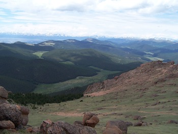
BisonTarraylls: Looking north from Bison Peak, at the Tarryall Mountains, of which it is a part. The close valley is Indian Creek valley, in which we followed Brookside-McCurdy Trail from Lost Park Campground. South Park is beyond the Tarryalls to the left.
Please Log in or Create an account to join the conversation.


