MAD Hippies Life
Pawnee Buchanan Loop - Indian Peaks Wilderness
"The trail began to become quite elusive, covered with debris and indistinguishable from the surrounding landscape. To sum it up, it was quite a mess that took some time to navigate and get a good feel as to where the trail "should" be based on the topography. Route finding was demanding and at some point, was more of a guessing game than anything."
If you are looking for a challenging backpacking loop in the Colorado backcountry for two or three days, this is one you will want to consider. Though it can be done as an overnight trip, we highly recommend at least two days. Three or even four days would be perfect as there is so much to see and explore.
The Pawnee – Buchanan Loop is an incredible backpacking adventure through the heart of the Indian Peaks Wilderness that includes two mountain passes, endless alpine wildflowers, countless waterfalls, all types of wildlife and incredible Rocky Mountain views. In only 26 miles you will gain and lose nearly 13,200′. With a high point of 12,550 to a low point of 8,800′ this trail will throw everything at you and more.
It had only been a week since we did the Diamond Lake trip, a few weeks since the Heart and Rogers Peak Lake trip, we were all feeling it, especially the pups. We were concerned the Pawnee Buchanan Loop would be too much for them (and us) because we would spend much of the time carrying them and our gear. We made the tough decision for one of us to stay back while the other went alone. It was decided, Debbie would make a base camp with the pups at Brainard Lake in the Pawnee Campground while Miller would take on the loop. Hindsight, we don't like being apart from each other and this was not something we will do again. Indeed, we have plans to go again and enjoy this one together, though it might take us longer, making shorter days with less mileage, we will do it together, as it should be.
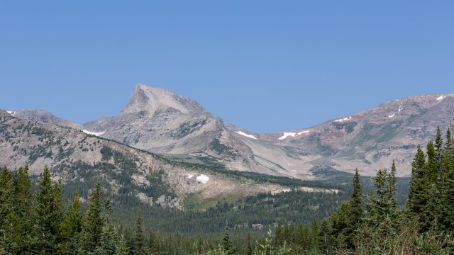
Heading off on the Beaver Creek / Mt Audubon Trail, it was a quick climb out of the Brainard Lake basin which begins at 10,500′. The trail quickly passes through tree line and the views expand as you make the approach along the boulder-laden path to the split for Mt Audubon. While Mt Audubon (13,209′) is a great destination, it was not in the plans this time, the loop continues along the Beaver Creek Trail which drops quickly from the shoulder of Mt Audubon and soon puts you back in the trees. Navigating downhill quickly here one can only think of the climb that awaits to head back up and over Buchanan Pass. The drop from the split (11,381′) to the Coney Flats area (9,790′) along the Beaver Creek Trail is easy on the legs and lungs as are the great views of the upcoming destination as you continue on the loop. From here you can see Sawtooth Mountain (12,304′), Buchanan Pass (11,837′) and the nearing climb that will take you there.
Once you begin to leave Coney Flats you soon find yourself gaining altitude again. There are many trails in the area, continue following the Beaver Creek Trail and be diligent following signs at the various trail junctions or you could find yourself on an altogether new adventure quickly! Though the climb is somewhat mellow at first, it becomes more aggressive as you near tree line where the views begin again of the surrounding Indian Peaks Wilderness. There is a small lake in the area, Red Deer Lake (10,372′), that would make for a great place to stop for the night or even to explore, time permitting. Again, be diligent watching for trail signs as the junction for the lake can be obscured by vegetation. The trail junction for the lake is also the end of the Beaver Creek Trail as now you will be following the Buchanan Pass Trail.
Today, however, it was all about mileage and getting up and over the pass. Once the trees thin, the trail becomes quite exposed for several miles (2.5) until back down to tree line on the other side of Buchanan Pass. It would be wise to know the weather before heading up and over as it is several miles of exposure. On this day, bluebird skies, intense sun and light winds. The pass is a straight approach, with only one switchback, if you can really call it that. Put one foot in front of the other and press on, the reward is coming.
Once atop the pass the views are just spectacular. The craggy peaks, velvety tundra and wildflowers were incredible. A tough climb with an awesome reward. This is one of those places you try and imagine beforehand, when planning your trip and thinking about what the pass might look like. Once there, your previous visions are dashed, replaced with an even more sensational sight. Time permitting, the pass is a great place to stop, refuel and soak in the views. A quick side trip to summit Sawtooth Mountain is also feasible. The Indian Peaks Wilderness does not disappoint, especially above tree line.
Now that the hard part is over, you begin a slow and methodical decent. Careful, if you are like us, you will be looking at the scenery and not where you are stepping. As you come off the pass, a fairly quick drop will put you out onto an alpine shelf where camping is possible, wildflower viewing is plentiful and the picture taking is off the charts. The trail will prick your curiosity to continue, though the current location will beg you to stay. Hindsight, this would be a grand place to camp for the night and explore a bit more. As noted earlier, this loop can easily expand into three to four days. While not big on mileage, the overall appeal of this trail is the immensely beautiful landscape. The Indian Peaks Wilderness has always held a special place in our hearts and if you find yourself exploring here, you'll quickly discover why.
Continuing down the trail, and back below tree line, the excitement is not over. There is so much more coming! From the pass the trail loses 3,000′ in 5.7 miles, traveling downward all the way to the Cascade Creek and Buchanan Creek confluence all the while flanking Thunderbolt Peak (11,938′). While this is easy travel, after the big climb up to Buchanan Pass, today it would prove somewhat challenging as there was a severe wind event over the previous winter. Several large trees had fallen, either snapping or unearthing. It was like traveling through a field of Lincoln Logs! Every time you might think the worst of it is over, another downed tree the size of a bus would have you navigate up, over, around, under or just plain old bushwhacking to get around it.
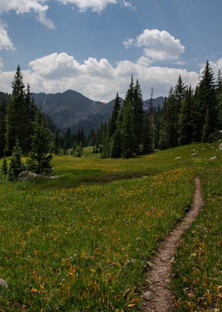
Thankfully the downed trees did subside and soon another magical destination came into view, Fox Park. Just when you thought you had seen it all, you emerge from a densely wooded area into a pristine meadow. Again, your imagination runs wild, you want to stop and explore. Behind you, the pass, towering peaks all around. In front the trail runs on disappearing into a wide opening where you drop, further still, toward the Cascade Creek drainage. A beautiful babbling creek cuts across the meadow, fresh snow melt begging to fill your water bottle. The woods surrounding, dense, dark and mysterious, you swear you are being watched and anticipate a moose to emerge at any moment. Fox Park is straight out of a wilderness adventure novel. Another great place to call it a day and camp before heading off to lower ground. Walk slowly, this is what you came for.
The trail drops again. Now a bit more aggressively, you can hear water as the Buchanan Creek drops in a torrent of white water cascading over a fall. Follow the creek, you and the creek are both heading in the same direction, down. The forest becomes dense again, the creek rushes alongside and you begin to wonder if the bottom will ever come. A few social trails head off in this area, be careful staying on the right path. Eventually a bend in the trail gives way to open views of the soon approaching bottom. You can begin to make out Cascade Creek drainage heading towards Cherokee Peak (12,130′), Mount Achonee (12,649′), Lone Eagle Peak (11,946′) and the Pawnee Cirque, the drainage is an incredibly lush valley you will soon travel.
Finally, you make the bottom, Cascade Creek and the end of the Buchanan Pass Trail. Take a right and you will be heading towards Monarch Lake alongside Buchanan Creek. Continue left to stay on the loop and now on the Cascade Creek trail with its many waterfalls. But here, the landscape is level, oddly flat and inviting to anyone wanting to pitch a tent. There are multiple sites in this area, camping is plentiful here. This intersection of trails and creeks makes for a good place to take a long and much needed break from hiking aggressively all morning. Consider soaking your tired feet in the cold running creek, enjoy a much-needed lunch, get in a good afternoon nap, or even camp for the night. Today, all of the above plus more mileage!
After a good nap and waking to the sun still up and filtering through the trees, it was all the inspiration it took to pack up and keep walking. There were still a few good hours of sunlight left and the decision to make this a one-night trip had already been made while climbing over Buchanan Pass earlier. Besides, the energy was odd, it felt weird to be out here alone. It had been quite some time since we had been separated for any measurable time, much less an overnight trip. It was obviously taking a toll and felt strange and downright uncomfortable. To put it into perspective, we met as teenagers nearly 40 years ago and have spent the better part of our lives spending as much time as possible together. We prefer it that way and cherish every minute we get. This outing just proved to us how much we really enjoy each other's company and desire to continue our lives as such. Besides, the mountains will always be here, we can come back together and do this the right way, as a couple.
Packed up, rested up and belly full, a few more miles would make the trip out the next morning just that much shorter. Though, no less spectacular. Pawnee Pass was still ahead, as was its looming 2,500′ climb out of the valley in just over three miles, the most dramatic portion being, the last mile climbing 1,100′ out of the Pawnee cirque along the switchbacks. The switchbacks are a great place to take it all in. Find the right boulder to sit or lean on, enjoy the views and take some photos. For now, hike till dusk, make camp and get through the night, alone. Tomorrow, more hiking, more climbing, Pawnee Pass and a much-needed reuniting.
It was no mistake; as the day went on, perhaps subconsciously and wanting something familiar, the area we had camped at in this area a few years before was approaching and fast becoming the destination for the night. It just felt somehow comforting and that in some way might make things easier. All the hiking, views and route finding keeps you busy, but when you stop, make camp and have nothing left to do but sit and wait for the morning light, well, your thoughts catch up with you.
There were grand waterfalls in the area, wonderful displays of the force of what water can do as it cascades through a valley, carving out earth and creating its own path on its journey. The sound was incredible, deafening at times, though somehow hypnotic to the weary traveler. Our original campsite came into view, trees down everywhere, continued proof of the violent storms from the past winter. There was just enough room to put up the tent and make camp for the night. While the site was not as pristine as it was the first time, the memories were still intact and that was enough. The roar of the creek cascading over the nearby fall and the memories of our first visit here seemed to relax the weird energy and soon sleep followed.
The next morning was met with the anticipation of finishing the trail. It was dark and cold. The only light, and heat mind you, were coming from the camp stove and headlamp. Nothing to do but drink coffee and wait for dawn to provide enough light for travel. Eventually the sun would soon rise over the granite walls that surrounded the ever-tightening valley and provide some much welcome warmth. The cirque that Pawnee Pass and Lake were in was close. The trail split would not be far. The sky was painting itself with vivid and blended colors of blue, orange and some sort of reddish pink that only the Colorado sky is able to create. As dramatic as it was, it was time to get all packed up and ready for the trail. The end of the valley was coming, the walls were growing tighter and taller, closing a curtain of granite and rock all around. The peaks were becoming more jagged and consuming the landscape with their prominence. The only way out was either to turn around or climb.
The trail junction appeared. Lone Eagle Peak and Mirror Lake continued forward while the Pawnee Pass and Lake trail worked its way up and to the left. Left it was. Lone Eagle Peak and Mirror Lake would have to wait, again. We had still never been there, and certainly from what we've read about them, we would want to experience it together. Another reason to come back to this heavenly place buried so deep in the Indian Peaks Wilderness. Each year the permits to camp in the Mirror Lake and Lone Eagle Peak area go quickly!
Like coming off of Buchanan Pass, the trail leading up to Pawnee Lake was littered with downed trees, although this time much worse. The trail began to become quite elusive, covered with debris and indistinguishable from the surrounding landscape. To sum it up, it was quite a mess that took some time to navigate and get a good feel as to where the trail "should" be based on the topography. Route finding was demanding and at some point, was more of a guessing game than anything. Standing on the highest point and contemplating how to just start walking along massive trees that were now raised paths became necessary. The wind event that laid down these giants must have been extremely violent. By the looks of things, it was doubtful they fell gracefully. Pushing on, the intertwined web of downed trees dissipated and soon the path was clear again.
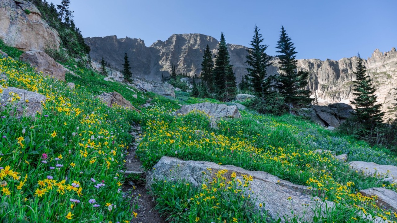
After the climb out of the Cascade Creek drainage, and over the debris from the wind event from the prior winter, it all comes slowly into view. The woods begin to thin as you arrive at the edge of Pawnee Lake. Catch your breath, take in the landscape and let your eyes drift across the lake to the towering peaks that rise up in the backdrop. Arriving at the Pawnee Cirque is dumbfounding, what is there to say? One feels quite small in the midst of such giants rising up out of the basin. These are the Caretakers of the Indian Peaks, walk slowly and respectfully in their midst. Camping here is everything an alpine adventure should be.
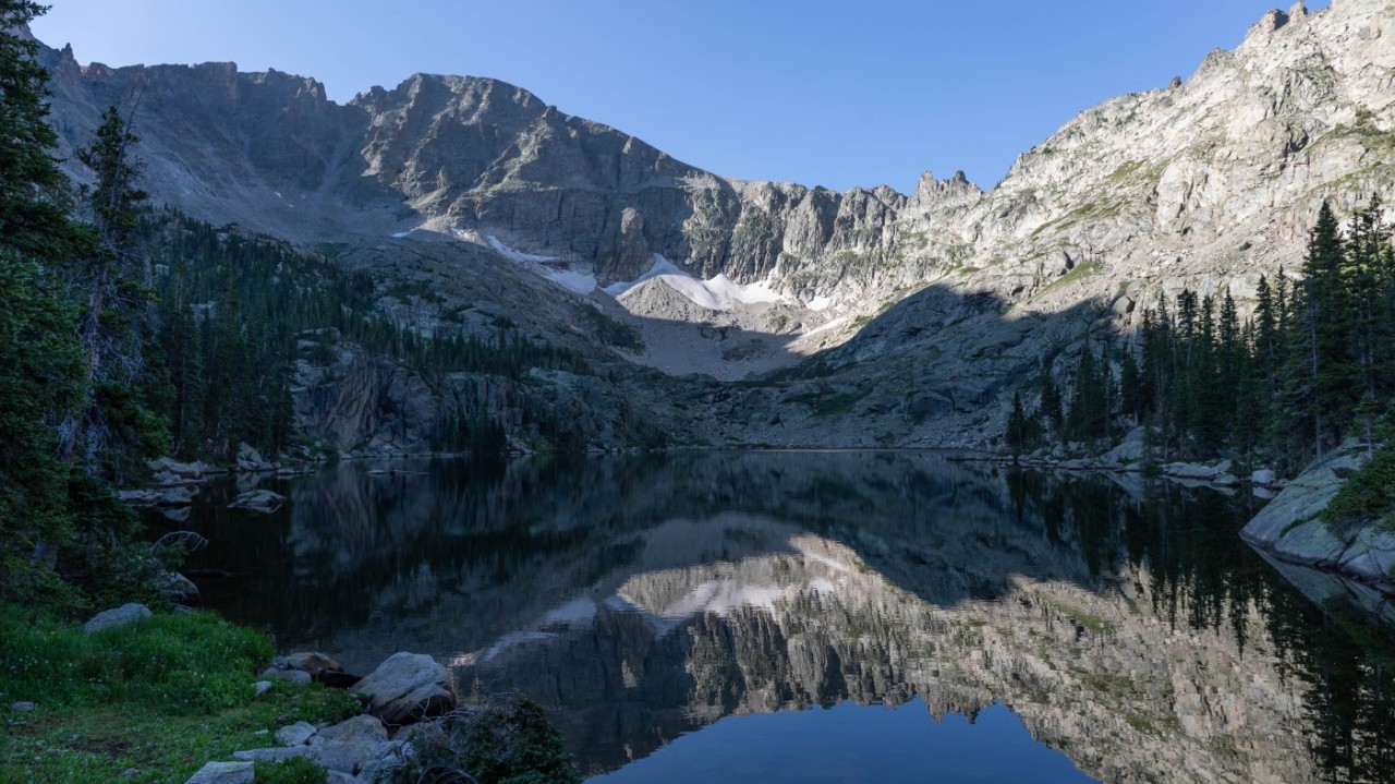
There are only two ways in or out of this place, both involve walking. One, obvious, going back the way you came. The second, heading forward, up and over Pawnee Pass, a rather impressive and yet intimidating task. The trail navigates around the lake, gaining a little altitude, the trees thin and you soon find yourself on the shelf staring up at the pass, wondering to yourself, where is the trail, how do I manage getting to the top? This is a good place to stop and consider your route up the Pawnee head-wall. Take a quick break, fuel up and study the lay of the land. Let your senses soak it all up. If you are lucky, you might be able to make out someone coming down or heading up, watch them, as far as you can. Before you know it, the contours become more obvious, and the route begins to make sense. As you begin to move forward, the trail just keeps exposing itself. Cairns, a semi-flat path and good route-finding skills will soon have you celebrating at the top of Pawnee Pass.
Slow and steady as you begin the climb up. Taking breaks here and there, with many opportunities for photography. The lake seems to shrink as the climb goes on. The valley below no longer hides its secrets as the vantage point from the climb now reveals all there is to see. The immensity of it all is incredible, and yet there is still more ground to gain. The path can be vague at times, cairns and moments of considering the surroundings will allow you to continue on. From a distance it is all quite overwhelming to look at, though in the midst of the climb, the switchbacks become more obvious, and the path forward leads on. This is no place to be caught in a storm, there is no place for shelter and nowhere to go quickly as going down is as difficult as going up. In this environment, the only thing that does happen quickly is the weather. A good rule of thumb, always navigate over Colorado mountain passes early in the day in order to avoid lightning.
The top of the pass was now in view, the ground began to level and travel along the trail and onto the pass eased. Here you can take a deep breath, a long look back down from where you came and congratulate yourself on a job well done. Soon you come to the Pawnee Pass – Continental Divide sign and the apex of the pass. It is all downhill from here! That is, unless you have it in you to take on Pawnee Peak, a mere 400′ climb from the pass. Or, for an even more adventurous climb, Shoshoni Peak at just under 13,000′.
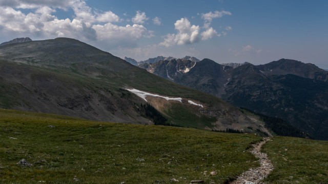
Heading on, you find yourself dropping down into the Brainard Lake area. No less impressive, as from this vantage point you are witness to the southern landscape of the Indian Peaks Wilderness. The trail drops onto an alpine bench with unbelievable views of lakes, peaks, valleys and more that paint the landscape as you continue to descend down along the Pawnee Pass trail. The area from the pass to tree line and water sources (3 miles) is very exposed. The journey downward is littered with scree fields that slowly give way to meadows filled with wildflowers, clear running creeks, impressive views and the fast approaching and very dramatic Lake Isabelle. Day hikers are plentiful in this area, rightfully so, it is beautiful.
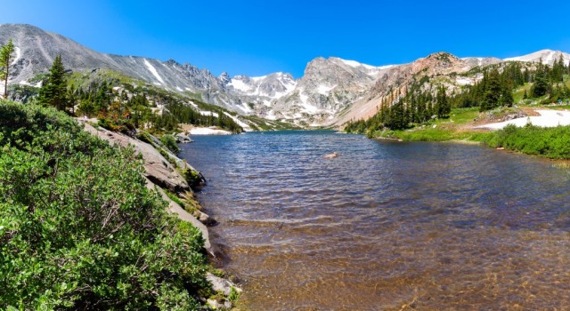
Once you arrive at Lake Isabelle you will wonder just how much more this trail has to offer. The backdrop is simply beautiful, towering above are Shoshoni Peak (12,967′), Apache Peak (13,441′), Navajo Peak (13,409′), the Niwot Ridge and the Isabelle Glacier. This lake is as picturesque as it gets! At the trail junction, go left. Right will take you to higher ground along the Isabelle Glacier trail, a worthy trip! The trail left leads out of the basin and soon drops into a dense alpine forest. Another junction appears with the Jean Lunning trail. Go left along Long Lake and soon you will arrive back at the parking areas and Brainard Lake. What a journey!
The Brainard Lake Recreation area makes for a great start, and finish, as it is just as breathtaking as the entire Buchanan Pawnee Pass Loop is. This loop is the epitome of what the Indian Peaks Wilderness has to offer. Though there are countless other trails in this wilderness area, as you encountered, this loop is as good as it gets. If you love the outdoors, backpacking and taking on a good challenge in the alpine, this one is for you. Do not forget, this area, as well as the entire Indian Peaks Wilderness, requires passes and permits for overnight camping.
Peace,
-MAD
A list of our gear can be found on Lighter Pack: Miller's Pack / Debbie's Pack
Vist MAD Hippies Life on our social media pages, YouTube, Instagram & Twitter