Tornado Warning
- jf1acai
-
 Topic Author
- Mountain Legend
-

Less
More
24 May 2014 18:42 #1
by jf1acai
Experience enables you to recognize a mistake when you make it again - Jeanne Pincha-Tulley
Comprehensive is Latin for there is lots of bad stuff in it - Trey Gowdy
Tornado Warning was created by jf1acai
TORNADO WARNING
COC059-250115-
/O.NEW.KBOU.TO.W.0027.140525T0038Z-140525T0115Z/
BULLETIN - EAS ACTIVATION REQUESTED
TORNADO WARNING
NATIONAL WEATHER SERVICE DENVER CO
638 PM MDT SAT MAY 24 2014
THE NATIONAL WEATHER SERVICE IN DENVER HAS ISSUED A
* TORNADO WARNING FOR...
EAST CENTRAL JEFFERSON COUNTY IN CENTRAL COLORADO...
* UNTIL 715 PM MDT
* AT 637 PM MDT...A SEVERE THUNDERSTORM CAPABLE OF PRODUCING A
TORNADO WAS LOCATED NEAR CHATFIELD RESERVOIR...OR 11 MILES
SOUTHWEST OF DENVER...MOVING NORTHWEST AT 10 MPH.
HAZARD...TORNADO AND QUARTER SIZE HAIL.
SOURCE...RADAR INDICATED ROTATION.
IMPACT...FLYING DEBRIS WILL BE DANGEROUS TO THOSE CAUGHT WITHOUT
SHELTER. MOBILE HOMES WILL BE DAMAGED OR DESTROYED.
DAMAGE TO ROOFS...WINDOWS AND VEHICLES WILL OCCUR. TREE
DAMAGE IS LIKELY.
* LOCATIONS IMPACTED INCLUDE...
SOUTHEASTERN LAKEWOOD...LITTLETON AND CHATFIELD RESERVOIR.
PRECAUTIONARY/PREPAREDNESS ACTIONS...
TAKE COVER NOW! MOVE TO A BASEMENT OR AN INTERIOR ROOM ON THE LOWEST
FLOOR OF A STURDY BUILDING. AVOID WINDOWS. IF IN A MOBILE HOME...A
VEHICLE OR OUTDOORS...MOVE TO THE CLOSEST SUBSTANTIAL SHELTER AND
PROTECT YOURSELF FROM FLYING DEBRIS.
Experience enables you to recognize a mistake when you make it again - Jeanne Pincha-Tulley
Comprehensive is Latin for there is lots of bad stuff in it - Trey Gowdy
Please Log in or Create an account to join the conversation.
- ScienceChic
-

- Mountain Champion
-

Less
More
- Posts: 15753
- Thank you received: 320
24 May 2014 18:44 #2
by ScienceChic
"Now, more than ever, the illusions of division threaten our very existence. We all know the truth: more connects us than separates us. But in times of crisis the wise build bridges, while the foolish build barriers. We must find a way to look after one another as if we were one single tribe.” -King T'Challa, Black Panther
The truth is incontrovertible. Malice may attack it. ignorance may deride it, but in the end, there it is. ~Winston Churchill
Replied by ScienceChic on topic Tornado Warning
The sirens just went off down here in Lakewood.
"Now, more than ever, the illusions of division threaten our very existence. We all know the truth: more connects us than separates us. But in times of crisis the wise build bridges, while the foolish build barriers. We must find a way to look after one another as if we were one single tribe.” -King T'Challa, Black Panther
The truth is incontrovertible. Malice may attack it. ignorance may deride it, but in the end, there it is. ~Winston Churchill
Please Log in or Create an account to join the conversation.
- jf1acai
-
Topic Author
- Mountain Legend
-
24 May 2014 19:04 #3
by jf1acai
Experience enables you to recognize a mistake when you make it again - Jeanne Pincha-Tulley
Comprehensive is Latin for there is lots of bad stuff in it - Trey Gowdy
Replied by jf1acai on topic Tornado Warning
TORNADO WARNING
COC059-250130-
/O.NEW.KBOU.TO.W.0028.140525T0057Z-140525T0130Z/
BULLETIN - EAS ACTIVATION REQUESTED
TORNADO WARNING
NATIONAL WEATHER SERVICE DENVER CO
657 PM MDT SAT MAY 24 2014
THE NATIONAL WEATHER SERVICE IN DENVER HAS ISSUED A
* TORNADO WARNING FOR...
NORTHEASTERN JEFFERSON COUNTY IN CENTRAL COLORADO...
* UNTIL 730 PM MDT
* AT 656 PM MDT...A SEVERE THUNDERSTORM CAPABLE OF PRODUCING A
TORNADO WAS LOCATED OVER EASTERN LAKEWOOD...OR 8 MILES WEST OF
DENVER...MOVING NORTHWEST AT 5 MPH.
HAZARD...TORNADO AND QUARTER SIZE HAIL.
SOURCE...RADAR INDICATED ROTATION.
IMPACT...FLYING DEBRIS WILL BE DANGEROUS TO THOSE CAUGHT WITHOUT
SHELTER. MOBILE HOMES MAY BE DAMAGED OR DESTROYED. DAMAGE TO
ROOFS...WINDOWS AND VEHICLES WILL OCCUR. TREE DAMAGE IS LIKELY.
* LOCATIONS IMPACTED INCLUDE...
LAKEWOOD...WHEAT RIDGE AND SOUTHEASTERN GOLDEN.
PRECAUTIONARY/PREPAREDNESS ACTIONS...
TAKE COVER NOW! MOVE TO A BASEMENT OR AN INTERIOR ROOM ON THE LOWEST
FLOOR OF A STURDY BUILDING. AVOID WINDOWS. IF IN A MOBILE HOME...A
VEHICLE OR OUTDOORS...MOVE TO THE CLOSEST SUBSTANTIAL SHELTER AND
PROTECT YOURSELF FROM FLYING DEBRIS.
Experience enables you to recognize a mistake when you make it again - Jeanne Pincha-Tulley
Comprehensive is Latin for there is lots of bad stuff in it - Trey Gowdy
Please Log in or Create an account to join the conversation.
- jf1acai
-
Topic Author
- Mountain Legend
-
24 May 2014 19:16 #4
by jf1acai
Experience enables you to recognize a mistake when you make it again - Jeanne Pincha-Tulley
Comprehensive is Latin for there is lots of bad stuff in it - Trey Gowdy
Replied by jf1acai on topic Tornado Warning
SEVERE WEATHER STATEMENT
NATIONAL WEATHER SERVICE DENVER CO
714 PM MDT SAT MAY 24 2014
COC059-250123-
/O.EXP.KBOU.TO.W.0027.000000T0000Z-140525T0115Z/
JEFFERSON CO-
714 PM MDT SAT MAY 24 2014
...THE TORNADO WARNING FOR EAST CENTRAL JEFFERSON COUNTY WILL EXPIRE
AT 715 PM MDT...
THE STORM WHICH PROMPTED THE WARNING FOR EAST CENTRAL JEFFERSON
COUNTY NEAR MARSTON RESERVOIR HAS MOVED OUT OF THE AREA. THEREFORE
THE WARNING WILL BE ALLOWED TO EXPIRE. HOWEVER SMALL HAIL AND HEAVY
RAIN ARE STILL POSSIBLE WITH THUNDERSTORMS IN THE AREA.
Experience enables you to recognize a mistake when you make it again - Jeanne Pincha-Tulley
Comprehensive is Latin for there is lots of bad stuff in it - Trey Gowdy
Please Log in or Create an account to join the conversation.
- ScienceChic
-
- Mountain Champion
-
Less
More
- Posts: 15753
- Thank you received: 320
24 May 2014 19:25 #5
by ScienceChic
"Now, more than ever, the illusions of division threaten our very existence. We all know the truth: more connects us than separates us. But in times of crisis the wise build bridges, while the foolish build barriers. We must find a way to look after one another as if we were one single tribe.” -King T'Challa, Black Panther
The truth is incontrovertible. Malice may attack it. ignorance may deride it, but in the end, there it is. ~Winston Churchill
Replied by ScienceChic on topic Tornado Warning
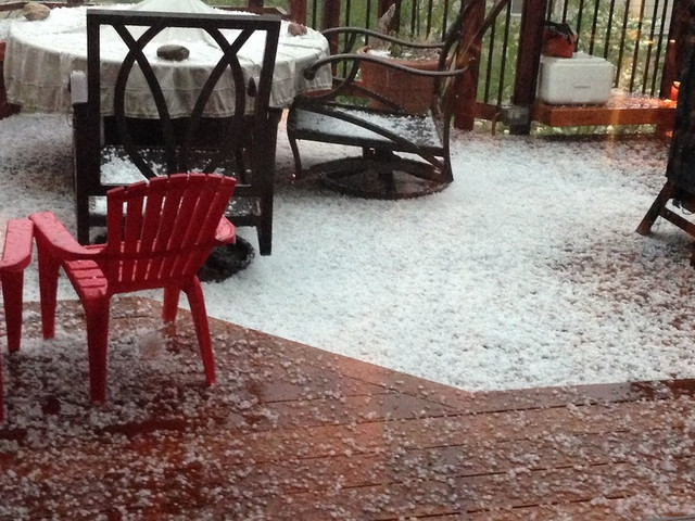
The sirens just went off again, but the tornado warning has been canceled and it's just a severe storm warning for up to 3/4" diameter hail, and 1/2" rain in 15 min possible.
"Now, more than ever, the illusions of division threaten our very existence. We all know the truth: more connects us than separates us. But in times of crisis the wise build bridges, while the foolish build barriers. We must find a way to look after one another as if we were one single tribe.” -King T'Challa, Black Panther
The truth is incontrovertible. Malice may attack it. ignorance may deride it, but in the end, there it is. ~Winston Churchill
Please Log in or Create an account to join the conversation.
- ScienceChic
-
- Mountain Champion
-
Less
More
- Posts: 15753
- Thank you received: 320
24 May 2014 19:41 #6
by ScienceChic
"Now, more than ever, the illusions of division threaten our very existence. We all know the truth: more connects us than separates us. But in times of crisis the wise build bridges, while the foolish build barriers. We must find a way to look after one another as if we were one single tribe.” -King T'Challa, Black Panther
The truth is incontrovertible. Malice may attack it. ignorance may deride it, but in the end, there it is. ~Winston Churchill
Replied by ScienceChic on topic Tornado Warning
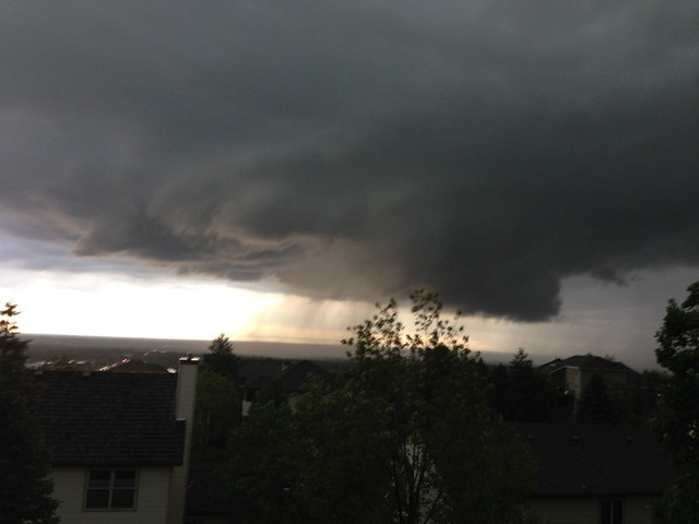
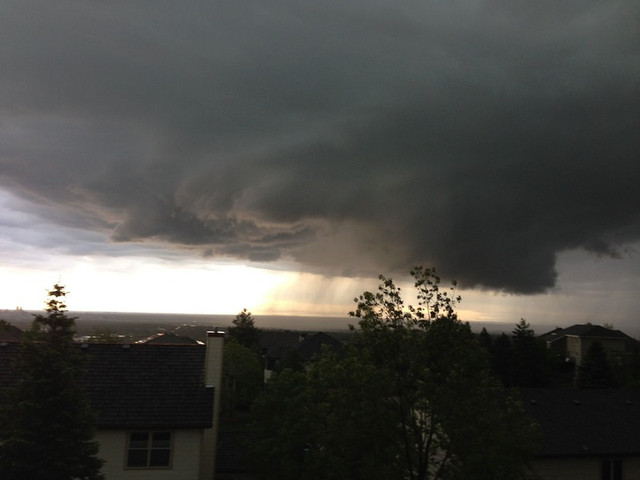
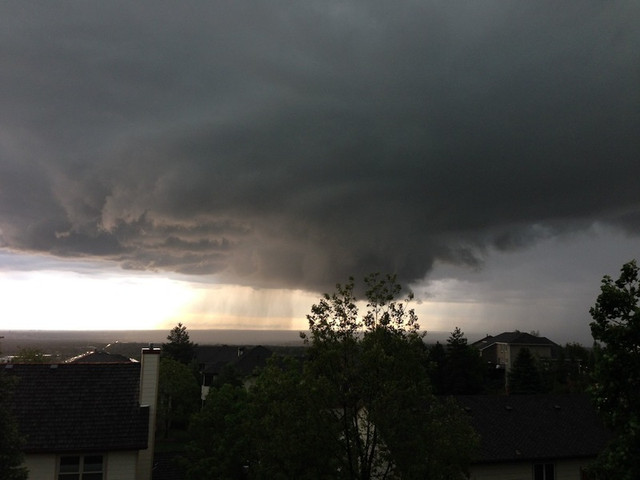
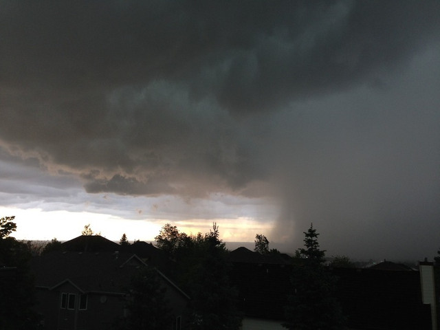
The progression of this storm was totally wicked to watch! All told it was about 30 minutes from the first photo to the last. I'm no meteorologist, but it seemed like the rotation was way too slow to form a tornado. It was massive and right between us and downtown Denver though.
I shot some video I'm processing right now, I'll toss that up in a bit if it's good enough. Not sure if I was able to capture the movement well or not. *edit to add: nope, nothing good so I'm not going to upload it. And my poor irises and basil were shredded.
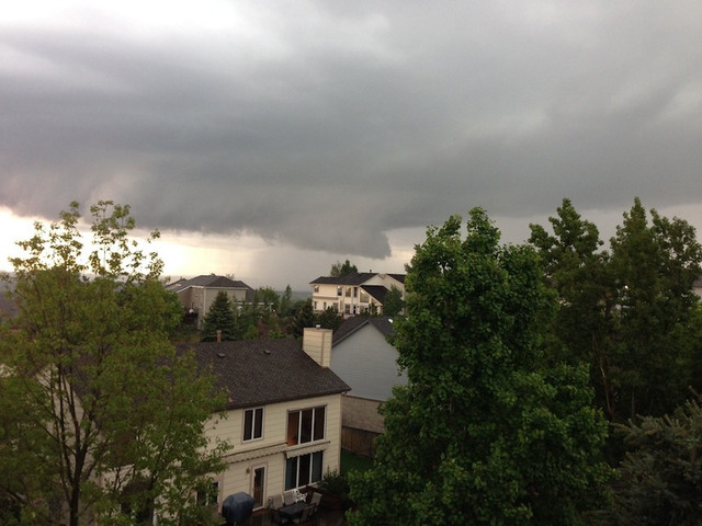

You can see the highrises in downtown Denver between the tree furthest to the left and the one next to it on the right that stick up the highest.
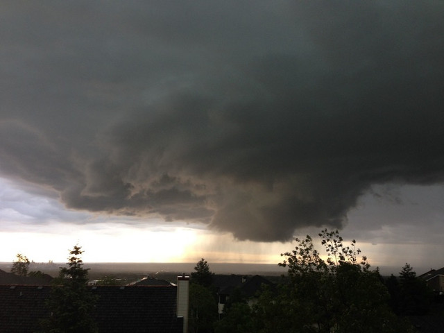
The storm kept moving NE and you can barely make out the Denver skyline anymore (the trees that were on the far left in the last picture are now on the far right).

I shot some video I'm processing right now, I'll toss that up in a bit if it's good enough. Not sure if I was able to capture the movement well or not. *edit to add: nope, nothing good so I'm not going to upload it. And my poor irises and basil were shredded.
You can see the highrises in downtown Denver between the tree furthest to the left and the one next to it on the right that stick up the highest.
The storm kept moving NE and you can barely make out the Denver skyline anymore (the trees that were on the far left in the last picture are now on the far right).
"Now, more than ever, the illusions of division threaten our very existence. We all know the truth: more connects us than separates us. But in times of crisis the wise build bridges, while the foolish build barriers. We must find a way to look after one another as if we were one single tribe.” -King T'Challa, Black Panther
The truth is incontrovertible. Malice may attack it. ignorance may deride it, but in the end, there it is. ~Winston Churchill
Please Log in or Create an account to join the conversation.
- jf1acai
-
Topic Author
- Mountain Legend
-
24 May 2014 20:05 #7
by jf1acai
Experience enables you to recognize a mistake when you make it again - Jeanne Pincha-Tulley
Comprehensive is Latin for there is lots of bad stuff in it - Trey Gowdy
Replied by jf1acai on topic Tornado Warning
Just a continuation of this storm:
COC059-250430-
/O.NEW.KBOU.FA.Y.0016.140525T0139Z-140525T0430Z/
/00000.N.ER.000000T0000Z.000000T0000Z.000000T0000Z.OO/
JEFFERSON CO-
739 PM MDT SAT MAY 24 2014
THE NATL WEATHER SVC IN DENVER HAS ISSUED A
* URBAN & SMALL STREAM FLOOD ADVISORY FOR.
NORTHEASTERN JEFFERSON COUNTY IN CNTL CO.
* UNTIL 1030 PM MDT
* AT 736 PM MDT.A THUNDERSTORM PRODUCING HEAVY RAIN WAS LOCATED
NEAR GOLDEN.OR 14 MILES WEST OF DENVER.MOVING NW AT 10
MPH. OVER ONE-HALF INCH OF RAIN HAS FALLEN IN JUST 15 MINUTE NEAR
LENA GULCH IN GOLDEN.
* SOME LOCATIONS THAT WILL EXPERIENCE FLOODING INCLUDE.
SOUTHWESTERN ARVADA.NORTHWESTERN WHEAT RIDGE.GOLDEN.WHITE
RANCH OPEN SPACE & ROCKY FLATS.
ADDITIONAL RAINFALL UP TO ONE-HALF OF RAIN IS EXPECTED OVER THE
AREA. THIS ADDITIONAL RAIN WILL MAKE MINOR FLOODING.
THIS INCLUDES THE FOLLOWING STREAMS & DRAINAGES.WALNUT CREEK.
CLEAR CREEK.RALSTON CREEK.TUCKER GULCH.ROCK CREEK.COAL
CREEK.VAN BIBBER CREEK.BIG DRY CREEK & LITTLE DRY CREEK.
PRECAUTIONARY/PREPAREDNESS ACTIONS.
MOST FLOOD DEATHS OCCUR IN AUTOMOBILES. NEVER DRIVE YOUR VEHICLE INTO
AREAS WHERE THE WATER COVERS THE ROADWAY. FLOOD WATERS ARE USUALLY
DEEPER THAN THEY APPEAR. JUST ONE FOOT OF FLOWING WATER IS POWERFUL
ENOUGH TO SWEEP VEHICLES OFF THE ROAD. WHEN ENCOUNTERING FLOODED
ROADS MAKE THE SMART CHOICE.TURN AROUND.DONT DROWN.
Experience enables you to recognize a mistake when you make it again - Jeanne Pincha-Tulley
Comprehensive is Latin for there is lots of bad stuff in it - Trey Gowdy
Please Log in or Create an account to join the conversation.
- FOS
-

- Mountain Legend
-
Less
More
- Posts: 2050
- Thank you received: 0
25 May 2014 08:51 #8
by FOS
Replied by FOS on topic Tornado Warning
Amazing pics SC. Thsnks for posting. As you know....I watched from I 70 and you captured the storm beautifully.
Now that I know you and JF are safe....I can say that it was truly amazing to watch.
Now that I know you and JF are safe....I can say that it was truly amazing to watch.
Please Log in or Create an account to join the conversation.
Time to create page: 0.181 seconds
sponsors


