Update 04.28.19: Now a
Winter Storm Warning
MMT Weather Update:
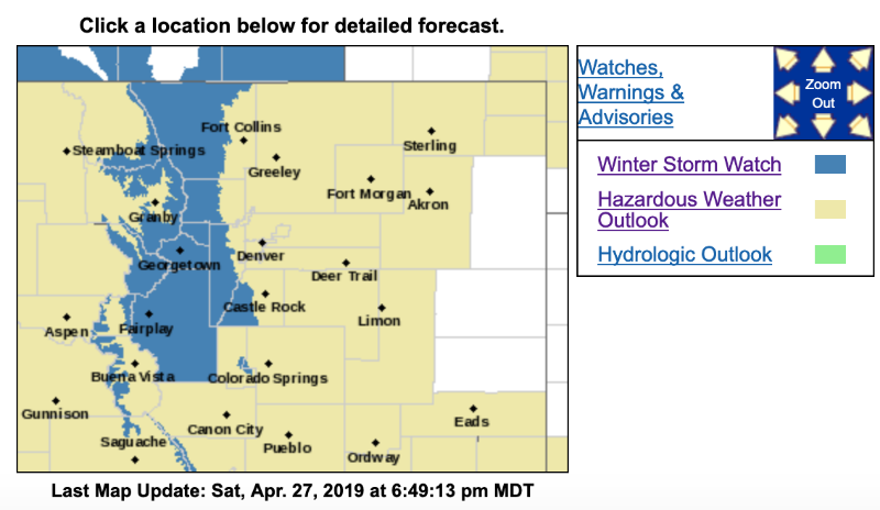
Winter Storm Watch...
The National Weather Service has issued a Winter Storm Watch, covering most of the MMT area, in effect from 6:00 a.m. Monday until 6:00 a.m. Tuesday. This is a "watch", not a "warning". A strong low pressure system will move across southern CO, Monday into Tuesday, and temperatures will be cold enough for snow. Periods of heavy snow will be possible, with forecast accumulation of 8 to 12 inches, and locally higher amounts are possible.
Winter Storm Watch
URGENT - WINTER WEATHER MESSAGE
National Weather Service Denver CO
246 PM MDT Sat Apr 27 2019
...
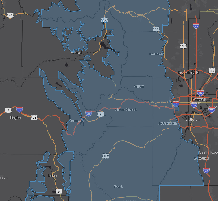
Winter storm watch in effect for the Northern and Central Mountains, Front Range Foothills and Park County for Monday into Tuesday...
.A Spring storm will move into the region starting Monday and continue into Wednesday with multiple rounds of moderate to heavy snow at times across northwestern and north central Colorado extending into Summit and Park counties. Higher amounts are expected over the central mountains and along I-70 South into Park county. Stay tune for additional updates to winter highlights.
COZ033>037-280500-
/O.NEW.KBOU.WS.A.0008.190429T1200Z-190430T1200Z/
Rocky Mountain National Park and the Medicine Bow Range-
The Mountains of Summit County, the Mosquito Range, and the Indian Peaks-
The Northern Front Range Foothills-
The Southern Front Range Foothills-South Park-
Including the cities of Cameron Pass, Laramie and Medicine Bow Mountains, Rabbit Ears Range, Rocky Mountain National Park, Willow Creek Pass, Berthoud Pass, Breckenridge, East Slopes Mosquito Range, East Slopes Southern Gore Range, Eisenhower Tunnel, Indian Peaks, Kenosha Mountains,
Mount Evans, Williams Fork Mountains, Winter Park, Estes Park, Glendevey, Nederland, Red Feather Lakes,
Bailey, Central City, Evergreen, Georgetown, Idaho Springs, Westcreek, Fairplay, Hartsel, Lake George, and South Park
246 PM MDT Sat Apr 27 2019
...WINTER STORM WATCH IN EFFECT FROM MONDAY MORNING THROUGH LATE MONDAY NIGHT...
* WHAT...Moderate to heavy snow possible.
Total snow accumulations of 8 to 12 inches with locally higher amounts up to 15 inches possible.
* WHERE...Rocky Mountain National Park and the Medicine Bow Range, The Mountains of Summit County, the Mosquito Range, and the Indian Peaks, The Front Range Foothills and South Park.
* WHEN...From Monday morning through Tuesday morning.
* ADDITIONAL DETAILS...Travel could be very difficult. The hazardous conditions could impact the morning or evening commute.
PRECAUTIONARY/PREPAREDNESS ACTIONS...
A Winter Storm Watch means there is potential for significant snow, sleet or ice accumulations that may impact travel. Continue to monitor the latest forecasts.