- Posts: 9631
- Thank you received: 219
- Forum
- Life Up the Hill
- Scanner & Emergency Info, Weather Forecasts
- #ElephantButteFire: Wildland fire north of Evergreen High School
#ElephantButteFire: Wildland fire north of Evergreen High School
- MountainTownAlerts
-
 Topic Author
- Mountain Legend
-

Less
More
14 Jul 2020 11:53 #31
by MountainTownAlerts
Replied by MountainTownAlerts on topic #ElephantButteFire: Wildland fire north of Evergreen High School
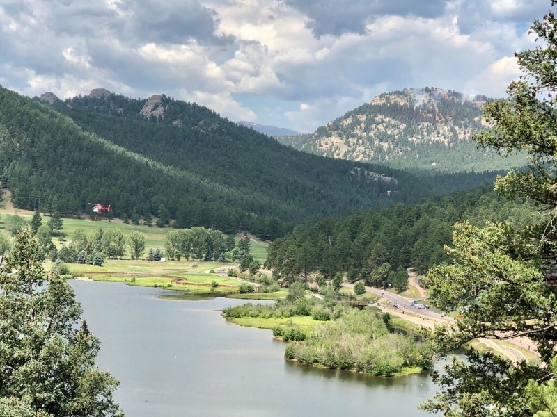
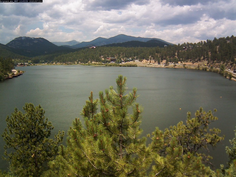
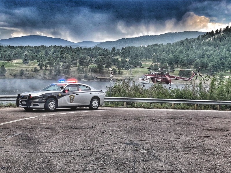
Air support has returned and is dropping water on the fire.
Photo by Chris Swathwood, AlphaPixel
View in our Evergreen Lake webcam
mymountaintown.com/weather-traffic/i-70-...-golden-to-evergreen
Video by Evergreen Fire Rescue
Photo by Chris Swathwood, AlphaPixel
View in our Evergreen Lake webcam
mymountaintown.com/weather-traffic/i-70-...-golden-to-evergreen
Video by Evergreen Fire Rescue
Please Log in or Create an account to join the conversation.
- MountainTownAlerts
-
 Topic Author
- Mountain Legend
-

Less
More
- Posts: 9631
- Thank you received: 219
14 Jul 2020 12:42 #32
by MountainTownAlerts
Replied by MountainTownAlerts on topic #ElephantButteFire: Wildland fire north of Evergreen High School
Jeffco Sheriff @jeffcosheriffco 39m
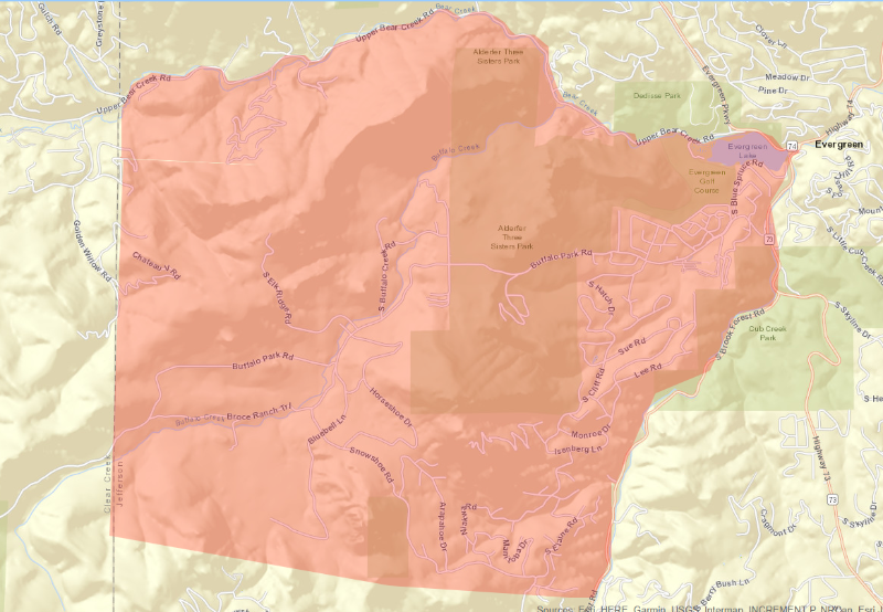
We've had several questions asking about firelines & evacuation zones. We hope this CodeRed map, which shows the entire evac area for the #ElephantButteFire answers those questions. It's based on CodeRed districts, which are based on ingress & egress points for neighborhoods
Forest Service, ARP @usfsarp
13 firefighters from the Arapaho and Roosevelt National Forests and Pawnee National Grassland continue to support fire suppression efforts.
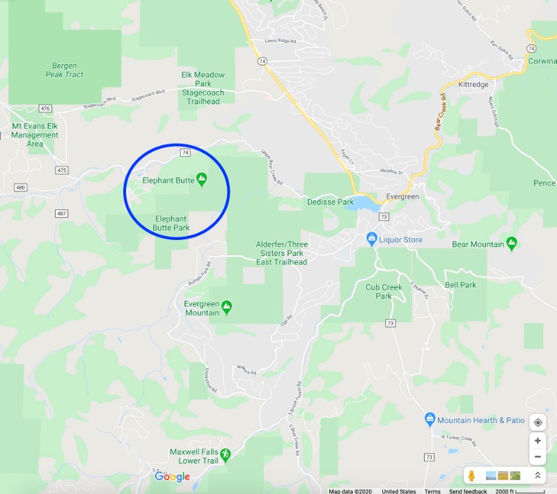
For reference as to where Elephant Butte is in relation to Downtown Evergreen and surrounding highways (more zoomed out view than the evacuation area map from Jeffco Sheriff above):
Please Log in or Create an account to join the conversation.
- MountainTownAlerts
-
 Topic Author
- Mountain Legend
-

Less
More
- Posts: 9631
- Thank you received: 219
14 Jul 2020 12:57 #33
by MountainTownAlerts
Replied by MountainTownAlerts on topic #ElephantButteFire: Wildland fire north of Evergreen High School
To all first responders on the fire: there are still about 20 lunches available at Aspen Ridge Church. Steak or chicken pre packed lunches from Qdoba.
Thank you for all your hard work!
Thank you for all your hard work!
Please Log in or Create an account to join the conversation.
- MountainTownAlerts
-
 Topic Author
- Mountain Legend
-

Less
More
- Posts: 9631
- Thank you received: 219
14 Jul 2020 13:03 #34
by MountainTownAlerts
Replied by MountainTownAlerts on topic #ElephantButteFire: Wildland fire north of Evergreen High School
Please Log in or Create an account to join the conversation.
- MountainTownAlerts
-
 Topic Author
- Mountain Legend
-

Less
More
- Posts: 9631
- Thank you received: 219
14 Jul 2020 13:10 #35
by MountainTownAlerts
Replied by MountainTownAlerts on topic #ElephantButteFire: Wildland fire north of Evergreen High School
Jeffco Sheriff @jeffcosheriffco 2m
We will be evaluating lifting any evacuation orders as the afternoon goes on depending on how containment goes. But we cannot guarantee any changes yes. Containment is currently at 25 percent and climbing #ElephantButteFire
We will be evaluating lifting any evacuation orders as the afternoon goes on depending on how containment goes. But we cannot guarantee any changes yes. Containment is currently at 25 percent and climbing #ElephantButteFire
Please Log in or Create an account to join the conversation.
- MountainTownAlerts
-
 Topic Author
- Mountain Legend
-

Less
More
- Posts: 9631
- Thank you received: 219
14 Jul 2020 13:35 #36
by MountainTownAlerts
Replied by MountainTownAlerts on topic #ElephantButteFire: Wildland fire north of Evergreen High School
Please Log in or Create an account to join the conversation.
- MountainTownAlerts
-
 Topic Author
- Mountain Legend
-

Less
More
- Posts: 9631
- Thank you received: 219
14 Jul 2020 13:44 - 14 Jul 2020 13:47 #37
by MountainTownAlerts
Replied by MountainTownAlerts on topic #ElephantButteFire: Wildland fire north of Evergreen High School
Last edit: 14 Jul 2020 13:47 by MountainTownAlerts.
Please Log in or Create an account to join the conversation.
- MountainTownAlerts
-
 Topic Author
- Mountain Legend
-

Less
More
- Posts: 9631
- Thank you received: 219
14 Jul 2020 15:52 #38
by MountainTownAlerts
Replied by MountainTownAlerts on topic #ElephantButteFire: Wildland fire north of Evergreen High School
Scanner: Local residents with ID can begin going back in at 1700 into Upper Bear Creek.
@jeffcosheriffco
We are lifting SOME of the evacuations as of 5pm today. However, evac orders REMAIN IN PLACE if you live on
*the north side of Buffalo Park Road between Le Masters Rd & South Jack Pine Rd; Le Masters RD, Buffalo Creek Rd
*Buffalo Creek Dr & South Elk Ridge Rd #ElephantButteFire
—-
Wondering how we decide when to lift evacuation orders? It’s a variety of factors, including weather, current and predicted fire behavior, containment , control and resource availability
Jeremy W Goldsmith 1hr ago
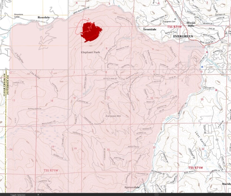
UNOFFICIAL MAP! (I'm a Cartographer on furlough from work). I'm bored. I decided to make a #ElephantButteFire Map. ~ Thank you, firefighters & hotshots! Using aerial images provided by @jeffcosheriffco Multi-Mission Aircraft and maps/GIS. I compiled this map as of July 14 @ 2PM
Light pink is the evac zone #codered. Thin pink outline is the a rough outline of the fire perimeter from July 13 at 7:30PM tweet. Red-elephant butte area is from 12:30PM tweet today. Please follow official updates from emergency service response units!
Please Log in or Create an account to join the conversation.
- MountainTownAlerts
-
 Topic Author
- Mountain Legend
-

Less
More
- Posts: 9631
- Thank you received: 219
14 Jul 2020 20:24 #39
by MountainTownAlerts
Replied by MountainTownAlerts on topic #ElephantButteFire: Wildland fire north of Evergreen High School
Jeffco Sheriff @jeffcosheriffco 1h
GOOD NEWS! Thanks to the rain that just soaked the area ALL #elephantbuttefire evacuations will be lifted as of 7pm! Control points will still be in place to allow only residents back into the area while crews are there
GOOD NEWS! Thanks to the rain that just soaked the area ALL #elephantbuttefire evacuations will be lifted as of 7pm! Control points will still be in place to allow only residents back into the area while crews are there
Please Log in or Create an account to join the conversation.
- MountainTownAlerts
-
 Topic Author
- Mountain Legend
-

Less
More
- Posts: 9631
- Thank you received: 219
15 Jul 2020 08:30 - 15 Jul 2020 14:08 #40
by MountainTownAlerts
Replied by MountainTownAlerts on topic #ElephantButteFire: Wildland fire north of Evergreen High School
Jeffco Sheriff @jeffcosheriffco 31m
The #elephantbuttefire is now 60% contained! Fire crews will continue to work on improving the line around the fire and attacking the hot spots in the interior. Residents still the only ones allowed in the area.
The #elephantbuttefire is now 60% contained! Fire crews will continue to work on improving the line around the fire and attacking the hot spots in the interior. Residents still the only ones allowed in the area.
Last edit: 15 Jul 2020 14:08 by MountainTownAlerts.
Please Log in or Create an account to join the conversation.
- Forum
- Life Up the Hill
- Scanner & Emergency Info, Weather Forecasts
- #ElephantButteFire: Wildland fire north of Evergreen High School
Time to create page: 0.392 seconds

