MMTwx from Chief Meteorologist Steve Hamilton:
Welcome To November...
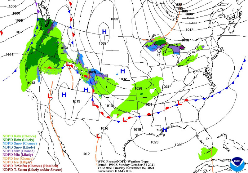
Weather map for November 1, 2021
Colder temperatures and scattered precipitation are expected to start the new month, and the new week. Cool high pressure is moving in from the north, and there is a batch of moist air on the leading edge of it. That will enter Colorado on Monday, and continue to bring a chance of rain and snow through at least Wednesday morning. Snow accumulation is expected to be light, but may cause some slick spots on the roadways. For most areas, there will be rain or a rain/snow mix in the afternoons as temperatures go above freezing. During the overnight hours, snow showers are possible to likely. The highest accumulations will be around Fairplay and Alma, where up to an inch or two will be possible. Much lower amounts elsewhere.
Details for each of our mountain towns and live, interactive radar:
mymountaintown.com/expert-local-weather
Tips for preparing your car and home for winter, CDOT regulations for traction and chain laws, and more:
Preparing for Winter in the Mountains
Post what you see and experience to help your neighbors here
Hwy 285 Road Conditions
or here
I-70 Road Conditions.
If you are on Facebook, use
285 Traveler Morrison, Conifer, Pine, Bailey areas
and
I-70 Traveler Golden, Evergreen, Idaho Springs, Georgetown, Vail.
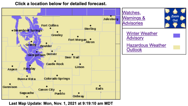
Winter Weather Advisory
URGENT - WINTER WEATHER MESSAGE
National Weather Service Denver CO
909 AM MDT Mon Nov 1 2021
...SNOW IN THE COLORADO MOUNTAINS WITH HAZARDOUS TRAVEL CONDITIONS
AT TIMES THROUGH WEDNESDAY MORNING...
.Snow showers will occur today, and may be briefly heavy with travel
impacts mainly over and near the mountain passes. More widespread
and persistent snow is expected to develop Tuesday and continue
through Tuesday night. Snow will decrease by Wednesday morning.
COZ031-033-034-012315-
/O.NEW.KBOU.WW.Y.0031.211101T1509Z-211103T1500Z/
West Jackson and West Grand Counties Above 9000 Feet-
South and East Jackson/Larimer/North and Northeast Grand/Northwest Boulder Counties Above 9000 Feet-
South and Southeast Grand/West Central and Southwest Boulder/Gilpin/
Clear Creek/Summit/North and West Park Counties Above 9000 Feet-
Including the cities of East Slopes Mosquito Range, Indian Peaks, Eisenhower Tunnel, Rocky Mountain National Park,
East Slopes Southern Gore Range, Mt Zirkel,
Mount Evans, Laramie and Medicine Bow Mountains, Cameron Pass,
Breckenridge, Kenosha Mountains, Winter Park, Williams Fork Mountains, Willow Creek Pass, Rabbit Ears Range, and Berthoud Pass
909 AM MDT Mon Nov 1 2021
...
WINTER WEATHER ADVISORY IN EFFECT UNTIL 9 AM MDT WEDNESDAY...
* WHAT...
Snow ongoing. Total snow accumulations 5 to 12 inches, with locally higher amounts along and north of a line from Rabbit Ears pass to Rocky Mountain National Park.
* WHERE...Rabbit Ears Pass, Rocky Mountain National Park and the Medicine Bow Range, and The Mountains of Summit County, the Mosquito Range, and the Indian Peaks.
* WHEN...Until 9 AM MDT Wednesday.
* IMPACTS...Travel could be difficult. The hazardous conditions could impact travel today through Wednesday morning.
PRECAUTIONARY/PREPAREDNESS ACTIONS...
Slow down and use caution while traveling. The latest road conditions for Colorado can be obtained by calling 5 1 1 or by going to
www.cotrip.org
For more information from the National Weather Service, visit
weather.gov/bou