- Posts: 6393
- Thank you received: 18
Help please - can someone name a mountain?
- LOL
-

- Mountain Legend
-

Less
More
29 Feb 2012 07:48 #11
by LOL
If you want to be, press one. If you want not to be, press 2
Republicans are red, democrats are blue, neither of them, gives a flip about you.
Replied by LOL on topic Help please - can someone name a mountain?
Here you go PF, found this on some biker blog - supposed to be a pic taken on Mt Evans Blvd.
http://redlegsrides.blogspot.com/2009/0 ... inter.html

http://redlegsrides.blogspot.com/2009/0 ... inter.html
If you want to be, press one. If you want not to be, press 2
Republicans are red, democrats are blue, neither of them, gives a flip about you.
Please Log in or Create an account to join the conversation.
- pacamom
-

- Mountain Legend
-
Less
More
- Posts: 2573
- Thank you received: 33
29 Feb 2012 08:30 #12
by pacamom
Replied by pacamom on topic Help please - can someone name a mountain?
So is that Rosalie in the middle? Snow covered? What's to the left, and is that Mt Evans on the right? The pointed one? If the one in the middle is Rosalie, is there a road that traverses it?
Please Log in or Create an account to join the conversation.
- JSG
-

- Visitor
-

29 Feb 2012 09:48 #13
by JSG
Replied by JSG on topic Help please - can someone name a mountain?
Please Log in or Create an account to join the conversation.
- ScienceChic
-
 Topic Author
- Mountain Champion
-

Less
More
- Posts: 15751
- Thank you received: 320
04 Mar 2012 10:59 #14
by ScienceChic
"Now, more than ever, the illusions of division threaten our very existence. We all know the truth: more connects us than separates us. But in times of crisis the wise build bridges, while the foolish build barriers. We must find a way to look after one another as if we were one single tribe.” -King T'Challa, Black Panther
The truth is incontrovertible. Malice may attack it. ignorance may deride it, but in the end, there it is. ~Winston Churchill
Replied by ScienceChic on topic Help please - can someone name a mountain?
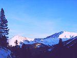
Can anybody help? Thanks! An update from our Facebook page:

Last week, I asked about the name of a mountain. Here is a picture of that elusive mountain; this was taken from Conestoga and Derringer Roads in Bailey, but it can also be seen easily from Deer Creek Elementary School, and "behind" Smokey when traveling northbound on 285 at the Roland Valley Curve. I would also like to know if it is possible to hike there. Does this help in identifying it? Thank you again for your help.
Last week, I asked about the name of a mountain. Here is a picture of that elusive mountain; this was taken from Conestoga and Derringer Roads in Bailey, but it can also be seen easily from Deer Creek Elementary School, and "behind" Smokey when traveling northbound on 285 at the Roland Valley Curve. I would also like to know if it is possible to hike there. Does this help in identifying it? Thank you again for your help.
"Now, more than ever, the illusions of division threaten our very existence. We all know the truth: more connects us than separates us. But in times of crisis the wise build bridges, while the foolish build barriers. We must find a way to look after one another as if we were one single tribe.” -King T'Challa, Black Panther
The truth is incontrovertible. Malice may attack it. ignorance may deride it, but in the end, there it is. ~Winston Churchill
Please Log in or Create an account to join the conversation.
- LOL
-
- Mountain Legend
-
Less
More
- Posts: 6393
- Thank you received: 18
05 Mar 2012 14:40 #15
by LOL
If you want to be, press one. If you want not to be, press 2
Republicans are red, democrats are blue, neither of them, gives a flip about you.
Replied by LOL on topic Help please - can someone name a mountain?
Not sure SC, could be the hills near Staunton State Park, whenever it finally opens there are going to be trails for hiking. Staunton is the only public lands near the area you are describing. Pike NF is further back near Harris Park.
http://www.parks.state.co.us/parks/stau ... unton.aspx
http://www.stauntonpark.com/staunton2/

http://www.parks.state.co.us/parks/stau ... unton.aspx
http://www.stauntonpark.com/staunton2/
If you want to be, press one. If you want not to be, press 2
Republicans are red, democrats are blue, neither of them, gives a flip about you.
Please Log in or Create an account to join the conversation.
- JSG
-
- Visitor
-
05 Mar 2012 19:15 #16
by JSG
Replied by JSG on topic Help please - can someone name a mountain?
I think the area SC is describing is ENE of the Meridian camp ground, behind Harris Park.
They are centered on this map: http://g.co/maps/xwnjz
They are centered on this map: http://g.co/maps/xwnjz
Please Log in or Create an account to join the conversation.
- TillerBee
-

- Happy Camper
-

Less
More
- Posts: 48
- Thank you received: 0
09 Mar 2012 16:38 #17
by TillerBee
Replied by TillerBee on topic Help please - can someone name a mountain?
[center:txeuv4xu]
 [/center:txeuv4xu]
Mount Goliath is also called Goliath Peak.
(yes, I spelled Roosevelt Lake wrong. ***sigh***)
Mount Goliath is also called Goliath Peak.
There is no road over Mount Rosalie. Along the front, Tanglewood Trail traverses the saddle between Rosalie and Rosedale Peak, starts going down past Roosevelt Lake and joins the Bear Track Lake trail down by the upper Bear Track Lake. The easiest way to get to the top of Rosalie is via the Mount Evans road, over Epaulet Mountain and then up Rosalie. Rosalie is very flat on top once you get there and you don't have a sense of being high.pacamom wrote: So is that Rosalie in the middle? Snow covered?... If the one in the middle is Rosalie, is there a road that traverses it?
(yes, I spelled Roosevelt Lake wrong. ***sigh***)
Please Log in or Create an account to join the conversation.
- raghorn
-

- Leaf Peeper
-

Less
More
- Posts: 36
- Thank you received: 0
12 Mar 2012 21:32 #18
by raghorn
Replied by raghorn on topic Help please - can someone name a mountain?
Science chic:
A Pike national Forest map will be big help as it shows the trails. Also try Google Earth.
A Pike national Forest map will be big help as it shows the trails. Also try Google Earth.
Please Log in or Create an account to join the conversation.
- Martin Ent Inc
-

- Mountain Legend
-
Less
More
- Posts: 6540
- Thank you received: 0
22 Mar 2012 14:03 #19
by Martin Ent Inc
Replied by Martin Ent Inc on topic Help please - can someone name a mountain?
You can access Rosalie from Guanella Pass as well as Mt Evans.
Please Log in or Create an account to join the conversation.
- AlpineMike
-
- Mountain Advisor
-

Less
More
- Posts: 256
- Thank you received: 0
31 Mar 2012 17:41 #20
by AlpineMike
Replied by AlpineMike on topic Help please - can someone name a mountain?
The mountain in your picture here is called Meridian Hill. I hiked to the summit on August 20, 2011. I can see this mountain from my deck. Coordinates Map Datum NAD83: N 39 deg 33,384' W 105 deg 29.190'
Science Chic wrote: Can anybody help? Thanks! An update from our Facebook page:
Last week, I asked about the name of a mountain. Here is a picture of that elusive mountain; this was taken from Conestoga and Derringer Roads in Bailey, but it can also be seen easily from Deer Creek Elementary School, and "behind" Smokey when traveling northbound on 285 at the Roland Valley Curve. I would also like to know if it is possible to hike there. Does this help in identifying it? Thank you again for your help.
Please Log in or Create an account to join the conversation.
Time to create page: 0.180 seconds
sponsors