- Posts: 15751
- Thank you received: 320
Help please - can someone name a mountain?
- ScienceChic
-
 Topic Author
- Mountain Champion
-

Less
More
31 Mar 2012 17:52 #21
by ScienceChic
"Now, more than ever, the illusions of division threaten our very existence. We all know the truth: more connects us than separates us. But in times of crisis the wise build bridges, while the foolish build barriers. We must find a way to look after one another as if we were one single tribe.” -King T'Challa, Black Panther
The truth is incontrovertible. Malice may attack it. ignorance may deride it, but in the end, there it is. ~Winston Churchill
Replied by ScienceChic on topic Help please - can someone name a mountain?
Thanks AlpineMike! I posted your answer on the Facebook post on our page asking about it.
"Now, more than ever, the illusions of division threaten our very existence. We all know the truth: more connects us than separates us. But in times of crisis the wise build bridges, while the foolish build barriers. We must find a way to look after one another as if we were one single tribe.” -King T'Challa, Black Panther
The truth is incontrovertible. Malice may attack it. ignorance may deride it, but in the end, there it is. ~Winston Churchill
Please Log in or Create an account to join the conversation.
- AlpineMike
-
- Mountain Advisor
-

Less
More
- Posts: 256
- Thank you received: 0
29 Apr 2012 13:53 - 06 May 2012 13:20 #22
by AlpineMike
Replied by AlpineMike on topic Help please - can someone name a mountain?
Also...you can hike to Meridian Hill with some dedicated effort. Begin your hike at Meridian Trail. Location to trailhead from
http://www.outdoor.com/activities/backp ... ian-trail/
[center:xr4fzbsh]"From Denver:
Drive west from Denver on U. S. Highway 285 approximately 28 miles to the traffic light before the top of Crow Hill. Turn right (northwest) on to Park County 43 and drive in a northwesterly direction for 6.8 miles to a “Y” in the road. Bear right. Go 1.5 miles, passing Meridian Campground on the left. Take the next left and turn left on Prospector Way. Go 0.8 miles past Camp Rosalie to the trailhead. The last mile is rough and can be muddy."[/center:xr4fzbsh]
The complete hike round trip to Meridian Hill from Meridian Trail (trail #604) is about 11 miles. The elevation gain is 2,743' with a 432' loss. Total elevation gain is 2,311. About 3.1 miles hike past "Meridian Campground" the one at 10,710 feet elevation and you will see a Arapaho Natl. Forest boundary sign (this area is the saddle south of Rosedale Peak). Continue north downhill where Meridian Trail forks at Cub Creek (trail #40) near the head of Indian Creek. TOPO! GPS Data Format Deg. Min. NAD83 39,33.405' N-105,31.426' W Bushwhack west from here 2.15 miles. The forest is dense and you will be hiking along a north facing slope at 10,600 ft. elevation. Keep a compass handy because you may find yourself walking north (down the slope) rather the west (along the slope). You will reach a creek from the Mud Lakes. Cross this creek and continue west uphill. After this short, steep incline after the creek, you will see a nice area flat enough for camping. Continue west and you will start up the west slope of Meridian Hill. Keep your eyes peeled for rock croppings and hazardous terrain. After you get out of the trees you will see the summit clearly. Once on top (11,490' elev.)...well you will be proud that you have accomplished this mountain!
Please research this hike before attempting. This is not an "easy" hike and navigation skills will be needed. Do not rely an a GPS device alone. Bring a map and compass and all the hiking essentials. There is no trail to the summit and the trees can pose a falling hazard, especially if windy. This is a long hike (11 miles) so start early. Good Luck and be safe.
Last edit: 06 May 2012 13:20 by AlpineMike.
Please Log in or Create an account to join the conversation.
- AlpineMike
-
- Mountain Advisor
-
Less
More
- Posts: 256
- Thank you received: 0
29 Apr 2012 14:15 #23
by AlpineMike
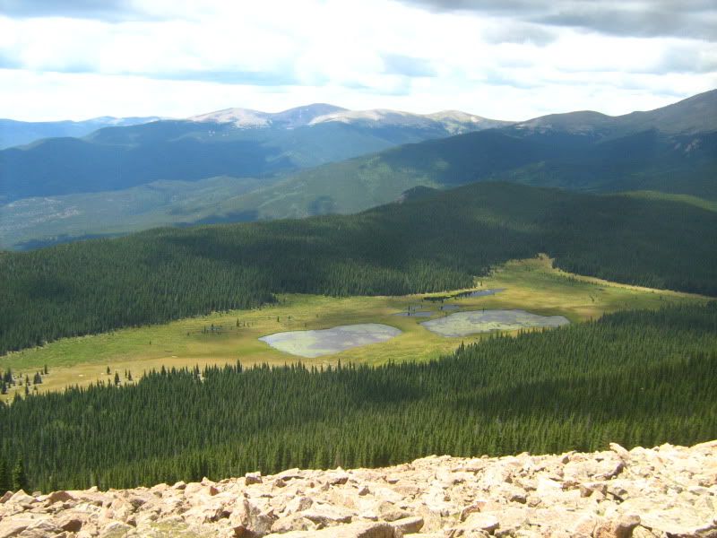
Mud Lakes viewed from the summit of Meridian Hill
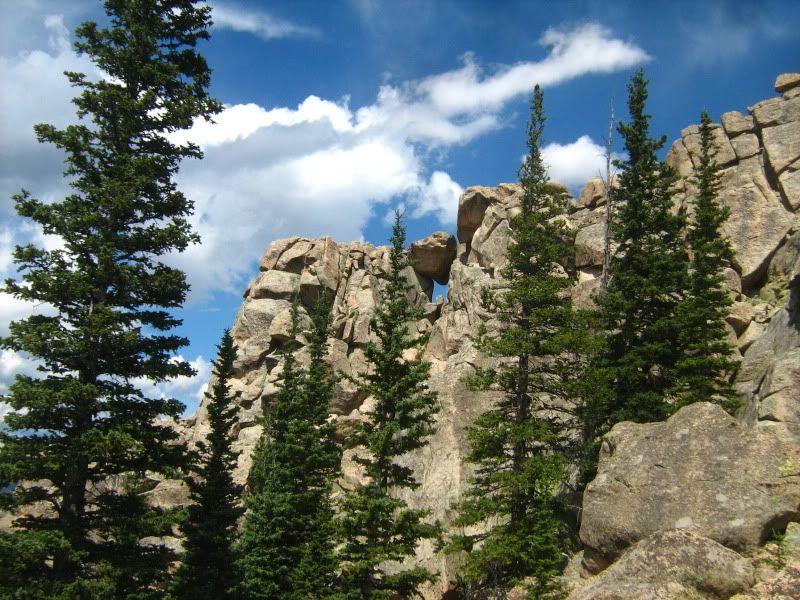
Rock Croppings along the west slope of Meridian Hill
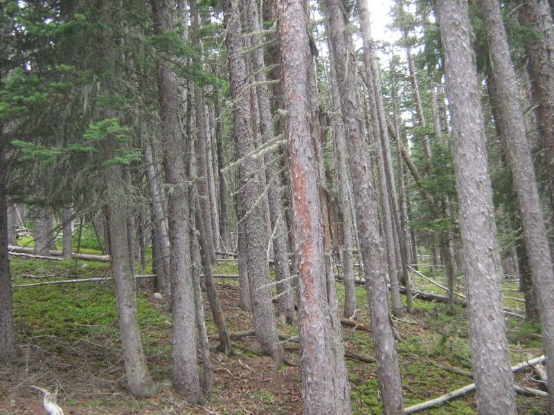
Dense Lodge Pole Pine forest bushwhack :thumbsup:
Replied by AlpineMike on topic Help please - can someone name a mountain?
Mud Lakes viewed from the summit of Meridian Hill
Rock Croppings along the west slope of Meridian Hill
Dense Lodge Pole Pine forest bushwhack :thumbsup:
Please Log in or Create an account to join the conversation.
- AlpineMike
-
- Mountain Advisor
-
Less
More
- Posts: 256
- Thank you received: 0
06 May 2012 10:48 - 06 May 2012 11:46 #24
by AlpineMike
Replied by AlpineMike on topic Help please - can someone name a mountain?
Updated information and topographic map image of the route provided for the summit of Meridian Hill with disclaimer. Please read.
AlpineMike wrote: Also...you can hike to Meridian Hill with some dedicated effort. Begin your hike at Meridian Trail. Location to trailhead from http://www.outdoor.com/activities/backp ... ian-trail/
[center:388zgrw5]"From Denver:
Drive west from Denver on U. S. Highway 285 approximately 28 miles to the traffic light before the top of Crow Hill. Turn right (northwest) on to Park County 43 and drive in a northwesterly direction for 6.8 miles to a “Y” in the road. Bear right. Go 1.5 miles, passing Meridian Campground on the left. Take the next left and turn left on Prospector Way. Go 0.8 miles past Camp Rosalie to the trailhead. The last mile is rough and can be muddy."[/center:388zgrw5]
The complete hike round trip to Meridian Hill from Meridian Trail (trail #604) is about 11 miles. The elevation gain is 2,743' with a 432' loss. Total elevation gain is 2,311. After hiking about 3.1 miles - hike past "Meridian Campground" the one at 10,710 feet elevation and you will see a "Mount Evans Wilderness" Arapaho Natl. Forest boundary sign (this area is the saddle south of Rosedale Peak). Continue north downhill where Meridian Trail forks at Cub Creek (trail #40) near the head of Indian Creek. TOPO! GPS Data Format Deg. Min. NAD83 39,33.405' N-105,31.426' W Bushwhack west from here 2.15 miles. The forest is dense and you will be hiking along a north facing slope at 10,600 ft. elevation. Keep a compass handy because you may find yourself walking north (down the slope) rather the west (along the slope). You will reach a creek from the Mud Lakes. Cross this creek and continue west uphill. After a short, steep incline after the creek, you will see a nice area flat enough for camping. Continue west and you will start up the west (ridge-like) slope of Meridian Hill. Keep your eyes peeled for rock croppings and hazardous terrain. After you get out of the trees you will see the summit clearly. Once on top (11,490' elev.)...well, you will be proud that you have accomplished this mountain!
Please research this hike before attempting. This is not an "easy" hike and navigation skills will be needed. Do not rely an a GPS device alone. Bring a map and compass and all the hiking essentials. There is no trail to the summit and the trees can pose a falling hazard, especially if windy. This is a long hike (11 miles) so start early. Good Luck and be safe.
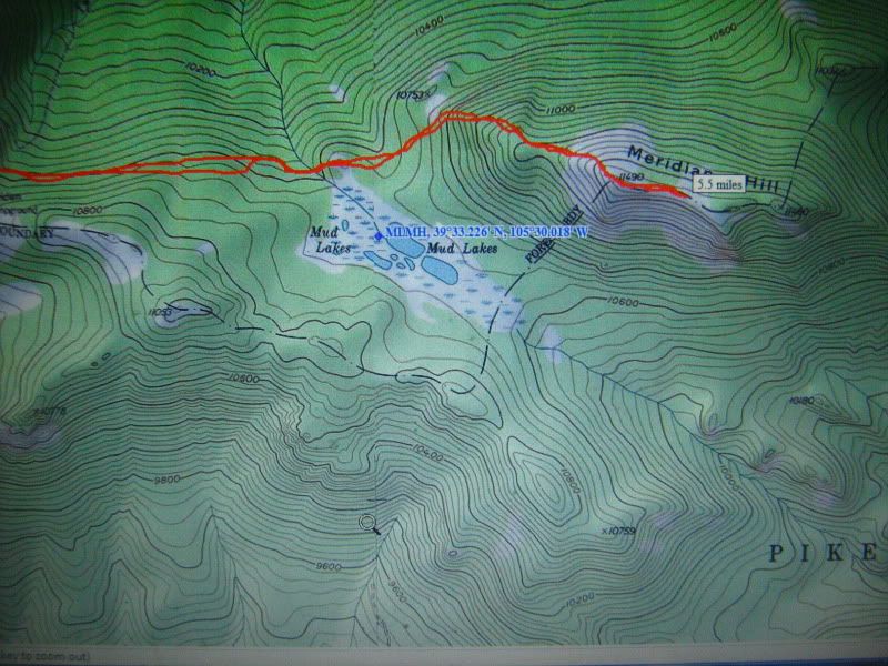
Disclaimer: This map image portrays the route I traveled off trail. Moderate to advanced navigation skills will be needed to maintain direction and location on this route. Please use good judgement and DO NOT attempt this hike without proper outdoor navigation training or experience. This route displayed WILL be attempted at YOUR OWN RISK; furthermore, anyone who attempts this route is responsible for their own personal safety and the author(s) and/or poster(s) WILL NOT be liable for any damage, injury, or loss of life that may occur.
Last edit: 06 May 2012 11:46 by AlpineMike.
Please Log in or Create an account to join the conversation.
- ScienceChic
-
Topic Author
- Mountain Champion
-
Less
More
- Posts: 15751
- Thank you received: 320
06 May 2012 11:22 #25
by ScienceChic
"Now, more than ever, the illusions of division threaten our very existence. We all know the truth: more connects us than separates us. But in times of crisis the wise build bridges, while the foolish build barriers. We must find a way to look after one another as if we were one single tribe.” -King T'Challa, Black Panther
The truth is incontrovertible. Malice may attack it. ignorance may deride it, but in the end, there it is. ~Winston Churchill
Replied by ScienceChic on topic Help please - can someone name a mountain?
Okay, I can tell I'm completely ignorant about hiking - if I did a route up a mountain, I'd have no clue as to how to figure out exactly where I walked on a topographic map. lol Thanks for that map AlpineMike - that's awesome!
"Now, more than ever, the illusions of division threaten our very existence. We all know the truth: more connects us than separates us. But in times of crisis the wise build bridges, while the foolish build barriers. We must find a way to look after one another as if we were one single tribe.” -King T'Challa, Black Panther
The truth is incontrovertible. Malice may attack it. ignorance may deride it, but in the end, there it is. ~Winston Churchill
Please Log in or Create an account to join the conversation.
- AlpineMike
-
- Mountain Advisor
-
Less
More
- Posts: 256
- Thank you received: 0
06 May 2012 12:49 #26
by AlpineMike
Hey SC (and other 285 friends)...I don't believe you are "ignorant" about hiking, but just need to acquire more understanding of navigation in difficult terrain. Acquiring the tools needed to understand terrain can become rather simple if you put your mind to it! After all, most anyone can walk a marked path, but with understanding and desire through motivation....anything is possible.
It takes some practice to understand location and distance traveled on foot...yet topographic maps are useful tools when used correctly; if not, they could become fuel for a campfire. :faint:
The compass is one primary tool used for accurate navigation, that is until you find you're located at the Earth's magnetic poles (where a compass has no use in such regions). Regardless of the region; you may never know "exactly" where you are on the map, yet you can get really close (within feet) with understanding and skill of outdoor mapping and navigation. A few books I recommend for navigation are: Mountaineering "Freedom of the Hills" published by The Mountaineers, The Complete Guide to Climbing and Mountaineering by author Pete Hill, Practical Outdoor Survival by author Len McDougall, and (a more difficult find) Be Expert with Map and Compass The "ORIENTEERING" Handbook by Bjorn Kjellstrom.
There are many reader friendly books on outdoor navigation, the main thing is applying the knowledge while in the field. It is highly suggested (if not required in some training) to practice in an area you are familiar with first so you do not become truly lost while attempting navigation in the "wild". Once you understand the basics....it becomes fun and exciting! You will challenge yourself more as you become more familiar and confident with your navigational "bag of tools" in your head (and backpack). But what if you lose the backpack??? The books and outdoor experiences will provide answers to suit most any situation.
Replied by AlpineMike on topic Help please - can someone name a mountain?
Science Chic wrote: Okay, I can tell I'm completely ignorant about hiking - if I did a route up a mountain, I'd have no clue as to how to figure out exactly where I walked on a topographic map. lol Thanks for that map AlpineMike - that's awesome!
Hey SC (and other 285 friends)...I don't believe you are "ignorant" about hiking, but just need to acquire more understanding of navigation in difficult terrain. Acquiring the tools needed to understand terrain can become rather simple if you put your mind to it! After all, most anyone can walk a marked path, but with understanding and desire through motivation....anything is possible.
It takes some practice to understand location and distance traveled on foot...yet topographic maps are useful tools when used correctly; if not, they could become fuel for a campfire. :faint:
The compass is one primary tool used for accurate navigation, that is until you find you're located at the Earth's magnetic poles (where a compass has no use in such regions). Regardless of the region; you may never know "exactly" where you are on the map, yet you can get really close (within feet) with understanding and skill of outdoor mapping and navigation. A few books I recommend for navigation are: Mountaineering "Freedom of the Hills" published by The Mountaineers, The Complete Guide to Climbing and Mountaineering by author Pete Hill, Practical Outdoor Survival by author Len McDougall, and (a more difficult find) Be Expert with Map and Compass The "ORIENTEERING" Handbook by Bjorn Kjellstrom.
There are many reader friendly books on outdoor navigation, the main thing is applying the knowledge while in the field. It is highly suggested (if not required in some training) to practice in an area you are familiar with first so you do not become truly lost while attempting navigation in the "wild". Once you understand the basics....it becomes fun and exciting! You will challenge yourself more as you become more familiar and confident with your navigational "bag of tools" in your head (and backpack). But what if you lose the backpack??? The books and outdoor experiences will provide answers to suit most any situation.
Please Log in or Create an account to join the conversation.
Time to create page: 0.157 seconds
sponsors