- Posts: 9704
- Thank you received: 220
- Forum
- Life Up the Hill
- Scanner & Emergency Info, Weather Forecasts
- #QuarryFire: Vegetation fire Homewood Park Ave and S Deer Creek Canyon Rd
#QuarryFire: Vegetation fire Homewood Park Ave and S Deer Creek Canyon Rd
- MountainTownAlerts
-
 Topic Author
- Mountain Legend
-

Less
More
02 Aug 2024 11:21 - 02 Aug 2024 11:37 #51
by MountainTownAlerts
Replied by MountainTownAlerts on topic #QuarryFire: Vegetation fire Homewood Park Ave and S Deer Creek Canyon Rd
Jeffco Sheriff 11:16am
#QuarryFire update:
- 431 acres; updated because of more detailed mapping from the MMA (Multi-Mission Aircraft)
- 4% containment
- Media presser has been moved from 2pm to 4pm at Valley Pkwy and South Valley Rd.
Edit to add: Jeffco Sheriff Quarry Fire media briefing:
www.youtube.com/live/CuTBknt1f6s?si=oZ6Ft-WVcPfANTsN&t=269
Last edit: 02 Aug 2024 11:37 by MountainTownAlerts.
Please Log in or Create an account to join the conversation.
- MountainTownAlerts
-
 Topic Author
- Mountain Legend
-

Less
More
- Posts: 9704
- Thank you received: 220
02 Aug 2024 12:28 #52
by MountainTownAlerts
Replied by MountainTownAlerts on topic #QuarryFire: Vegetation fire Homewood Park Ave and S Deer Creek Canyon Rd
Jeffco Sheriff 12:13pm
UPDATE: #QuarryFire media presser has been moved to 4:30pm at Valley Pkwy and South Valley Rd.
Jeffco Colorado 11:45am
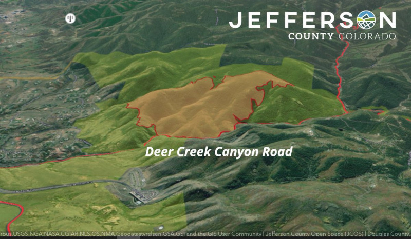
3D view of the #QuarryFire in Deer Creek Canyon. The area shaded in yellow is the fire perimeter.
Get the latest updates and information by following @jeffcosheriffco
or by visiting jeffco.us/quarry-fire . #Jeffco
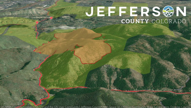
Here is a second view from the west looking east. Deer Creek Canyon Road is on the left side of the image.
Please Log in or Create an account to join the conversation.
- ScienceChic
-

- Mountain Champion
-

Less
More
- Posts: 15749
- Thank you received: 320
02 Aug 2024 14:35 - 02 Aug 2024 14:36 #53
by ScienceChic
"Now, more than ever, the illusions of division threaten our very existence. We all know the truth: more connects us than separates us. But in times of crisis the wise build bridges, while the foolish build barriers. We must find a way to look after one another as if we were one single tribe.” -King T'Challa, Black Panther
The truth is incontrovertible. Malice may attack it. ignorance may deride it, but in the end, there it is. ~Winston Churchill
Replied by ScienceChic on topic #QuarryFire: Vegetation fire Homewood Park Ave and S Deer Creek Canyon Rd
"Now, more than ever, the illusions of division threaten our very existence. We all know the truth: more connects us than separates us. But in times of crisis the wise build bridges, while the foolish build barriers. We must find a way to look after one another as if we were one single tribe.” -King T'Challa, Black Panther
The truth is incontrovertible. Malice may attack it. ignorance may deride it, but in the end, there it is. ~Winston Churchill
Last edit: 02 Aug 2024 14:36 by ScienceChic.
Please Log in or Create an account to join the conversation.
- MountainTownAlerts
-
 Topic Author
- Mountain Legend
-

Less
More
- Posts: 9704
- Thank you received: 220
02 Aug 2024 14:53 #54
by MountainTownAlerts
Replied by MountainTownAlerts on topic #QuarryFire: Vegetation fire Homewood Park Ave and S Deer Creek Canyon Rd
Requesting Air Attack to return including Large Air Tanker.
Please Log in or Create an account to join the conversation.
- MountainTownAlerts
-
 Topic Author
- Mountain Legend
-

Less
More
- Posts: 9704
- Thank you received: 220
02 Aug 2024 15:09 #55
by MountainTownAlerts
Replied by MountainTownAlerts on topic #QuarryFire: Vegetation fire Homewood Park Ave and S Deer Creek Canyon Rd
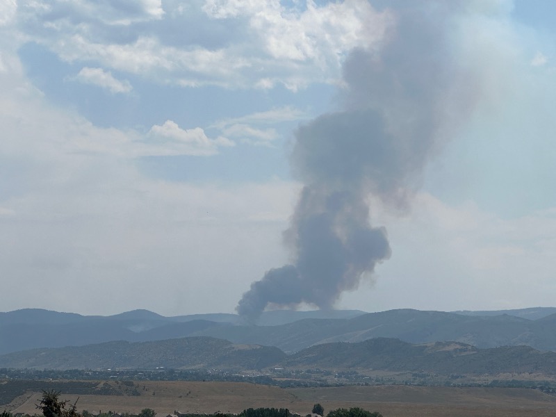
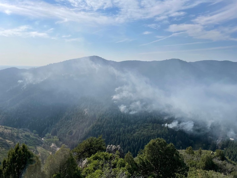
Jeffco Sheriff 3:03pm: You have likely noticed that we just had a plume of black smoke coming from the #QuarryFire. We want to reassure you that there is no reason to panic. Often when the wind changes direction, the fire will burn back in on itself. We are deploying air support to help put it out, but the new smoke is from within the burn area and likely hit a patch of unburned ground. (This photo was taken by a resident from the Evergreen area).
Please Log in or Create an account to join the conversation.
- MountainTownAlerts
-
 Topic Author
- Mountain Legend
-

Less
More
- Posts: 9704
- Thank you received: 220
02 Aug 2024 15:59 #56
by MountainTownAlerts
Replied by MountainTownAlerts on topic #QuarryFire: Vegetation fire Homewood Park Ave and S Deer Creek Canyon Rd
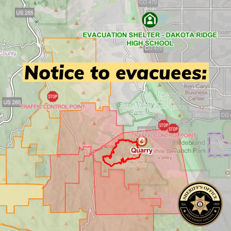
Jeffco Sheriff 4min ago: #QuarryFire evacuees ONLY: We are working on a plan to give residents access to their homes once it is safe to do so. ALL EVACUEES need to come to the evacuation site at Dakota Ridge High School, 13399 W. Coal Mine Ave., on Saturday or Sunday (8/3-8/4) between 10 a.m. – 3 p.m. to get a resident pass for re-entry. You must have proof of residency with you. The evacuation center will remain open as long as there are evacuees who need it. We will handle any special circumstances on a case-by-case basis. Again, there is no specific timeline for when residents can get back to their homes. This is for preparation purposes. If you are an evacuee and have questions, please visit the evacuation site for answers.
Please Log in or Create an account to join the conversation.
- MountainTownAlerts
-
 Topic Author
- Mountain Legend
-

Less
More
- Posts: 9704
- Thank you received: 220
02 Aug 2024 16:34 - 02 Aug 2024 17:47 #57
by MountainTownAlerts
Replied by MountainTownAlerts on topic #QuarryFire: Vegetation fire Homewood Park Ave and S Deer Creek Canyon Rd
Jeffco Sheriff Press Conference
430pm
Fire is up to 480 acres, 10% containment
225 firefighters on scene
2 firefighters suffered broken or twisted ankles
Investigation continues, call the tip line if you have a lead 303-271-5612, utilizing the state canine arson dog
If you've been evacuated, please check in at the evacuation site, even if you aren't staying there.
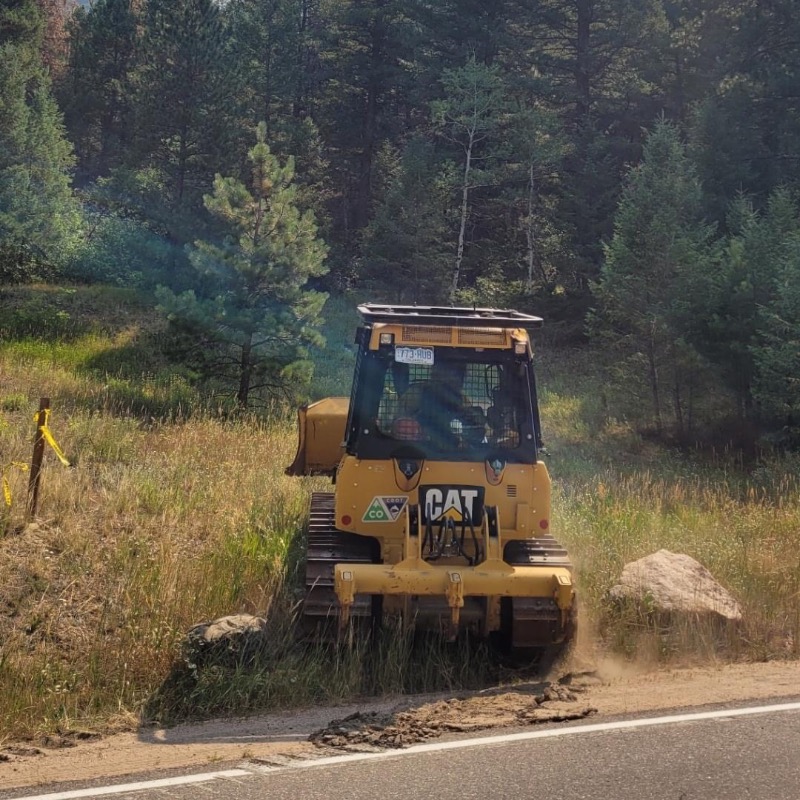
Biggest success today was connecting hand line and dozer line on south and east sides.
Next briefing is tomorrow at 8am
Last edit: 02 Aug 2024 17:47 by MountainTownAlerts. Reason: added containment percentage
Please Log in or Create an account to join the conversation.
- MountainTownAlerts
-
 Topic Author
- Mountain Legend
-

Less
More
- Posts: 9704
- Thank you received: 220
03 Aug 2024 17:40 #58
by MountainTownAlerts
Replied by MountainTownAlerts on topic #QuarryFire: Vegetation fire Homewood Park Ave and S Deer Creek Canyon Rd
Jeffco Sheriff 5:00pm briefing.
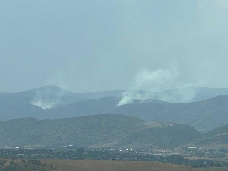
Photo taken by My Mountain Town 8/3/24 at 5:35pm
- 472 acres, and 20% containment
- 2 neighborhoods that had been evacuated are moved down to pre-evacuation status: Deer Creek Mesa and Kuehster
- If you have been evacuated and haven't yet gotten a badge to be let back into your neighborhood, you can stop by the Dakota Ridge Evacuation Center tomorrow from 5-8pm
- Expect to see a lot of smoke tomorrow - in the NW area, firefighters will be conducting back burns
- Will continue to have fire personnel in the area for a couple of weeks after it's under control as they will continue to monitor it
- They are still investigating the fire, if you saw anything and even if you don't think it's important, please call the tip line at 303-271-5612 to report the information
- East side and south side is in great shape with line around and mop up.
Photo taken by My Mountain Town 8/3/24 at 5:35pm
Please Log in or Create an account to join the conversation.
- MountainTownAlerts
-
 Topic Author
- Mountain Legend
-

Less
More
- Posts: 9704
- Thank you received: 220
04 Aug 2024 08:14 #59
by MountainTownAlerts
Replied by MountainTownAlerts on topic #QuarryFire: Vegetation fire Homewood Park Ave and S Deer Creek Canyon Rd
Quarry Fire 8/4/24 8am press briefing, notes:
- No update on acreage and containment.
- Conducted burns last night up until 1am on the northwest side where it's impossible for firefighters to get into the steep terrain. All open space, not neighborhoods.
- Helicopter support will continue today
- Temps expected to hit 90, humidity low today. Expecting higher rain chances tomorrow.
- Next briefing will be at 4:30pm, starting tomorrow, they will go to one briefing per day.
Please Log in or Create an account to join the conversation.
- MountainTownAlerts
-
 Topic Author
- Mountain Legend
-

Less
More
- Posts: 9704
- Thank you received: 220
04 Aug 2024 13:34 #60
by MountainTownAlerts
Replied by MountainTownAlerts on topic #QuarryFire: Vegetation fire Homewood Park Ave and S Deer Creek Canyon Rd
Additional info from Elk Creek Fire:
QUARRY FIRE UPDATE
8-4-24, 9:00am
472 acres, 20% containment
Resources: Over 225 firefighters, two Type 1 helicopters, one Type 2 helicopter, one Type 3 helicopter, 23 fire engines
Fire:
There was no significant increase in fire behavior on the #QuarryFire yesterday, and it remained moderated overnight. Conditions were good for crews to perform burning operations. The fire remains ¼ mile from the nearest home.
Operations activity:
In the north, firefighters are successfully holding the fire south of Deer Creek Canyon Rd. Similarly on the east and southeast sides, hand lines and dozer lines have remained effective. The west side of the fire is full of rugged and challenging terrain, some of it inaccessible. Firefighters are using planned burning operations in this area to remove fuel from the fire. They successfully performed these burning operations yesterday evening into the night, finishing up around 1am. (Late in the day and into the night is often when conditions are best for this work.) Conditions allowing, these burning operations will continue today, both with hand ignitions and ignitions from the air (helicopter or UAS/unmanned aircraft systems.) Smoke may be visible. Helicopters will continue supporting firefighters from the air today as needed.
REMEMBER, IF YOU FLY, WE CANNOT. All air operations will cease if there is a public drone in the air.
Weather:
Today (Sunday, Aug 4) remains warm and dry with highs in the lower 90s and minimum humidity of 18%. Winds are from the southwest at 5 to 8 mph until 9am, then variable around 5 mph until 12pm, then from the east 5 to 13 mph until 2pm, then from the northeast until 3pm, then from the north until 4pm, then shifting to westward. There is a chance of showers and thunderstorms after 12pm which could produce gusty and erratic winds. Relatively good overnight humidity recovery is expected overnight.
LONG TERM DISCUSSION: Sunday night through Thursday - Chances for high-based thunderstorms with gusty outflows will linger until midnight Sunday night. Increasing moisture will bring scattered showers and storms each afternoon with above normal temperatures expected through Wednesday. Thursday will bring a significant cool down and increased chances for widespread wetting rains across the forecast area.
Updates:
Two neighborhoods are no longer under a mandatory evacuation order and are back on pre-evacuation. They are Deer Creek Mesa and Kuehster. ONLY residents with credential cards specific to those neighborhoods will be allowed in. All road closures remain in place. Residents in those two neighborhoods must go to Dakota Ridge High School to pick up credentials. You will need to bring proof of residency with you.
Jefferson County is in a STAGE 2 FIRE BAN. Go here for info: www.jeffco.us/528/Fire-Ban-Details
Please Log in or Create an account to join the conversation.
- Forum
- Life Up the Hill
- Scanner & Emergency Info, Weather Forecasts
- #QuarryFire: Vegetation fire Homewood Park Ave and S Deer Creek Canyon Rd
Time to create page: 0.298 seconds

