- Posts: 9704
- Thank you received: 220
- Forum
- Life Up the Hill
- Scanner & Emergency Info, Weather Forecasts
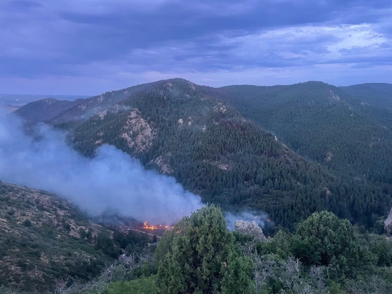
- #QuarryFire: Vegetation fire Homewood Park Ave and S Deer Creek Canyon Rd
#QuarryFire: Vegetation fire Homewood Park Ave and S Deer Creek Canyon Rd
- MountainTownAlerts
-
 Topic Author
- Mountain Legend
-

Less
More
04 Aug 2024 13:36 - 04 Aug 2024 14:40 #61
by MountainTownAlerts
Replied by MountainTownAlerts on topic #QuarryFire: Vegetation fire Homewood Park Ave and S Deer Creek Canyon Rd
From Jeffco Sheriff 9min ago:
Due to ongoing firefighting activities and to ensure safety,
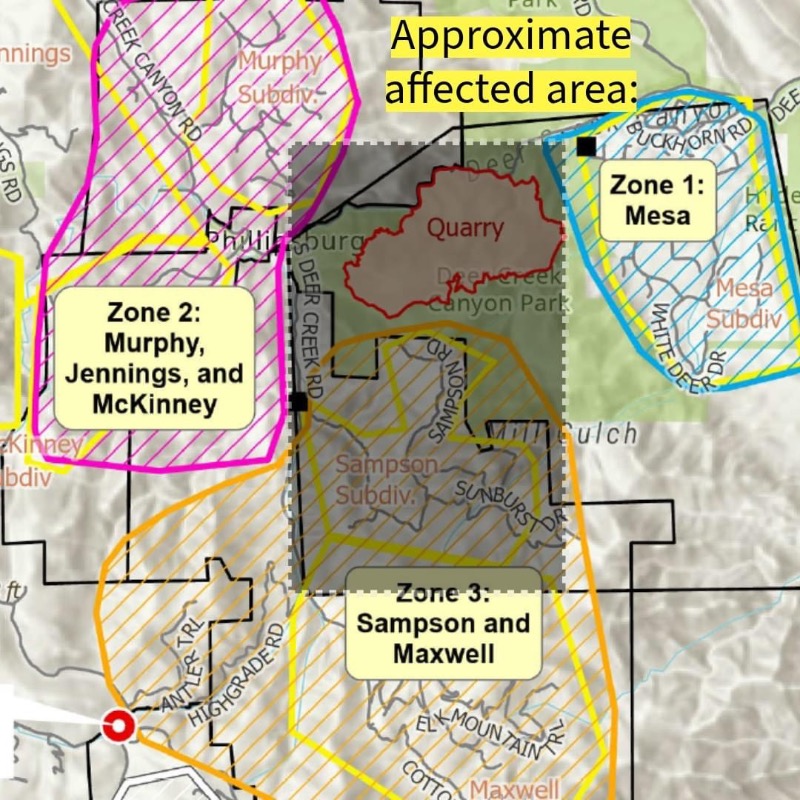
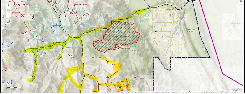
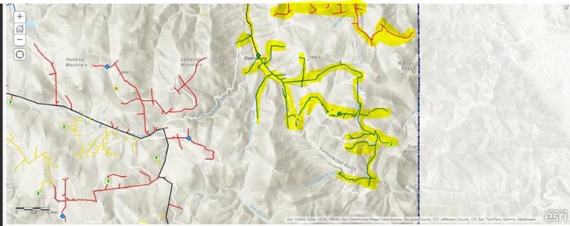
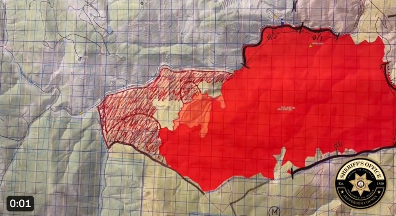
CORE Electric Cooperative will be shutting off power for approximately 48 hours in these affected areas in #QuarryFire: From the intersection of Grizzly Dr. and Deer Creek Canyon Rd. west to South Deer Creek Rd. and everything south of that area for 3 miles. Some homes in the Sampson neighborhood will be affected. That area is still under mandatory evacuations.
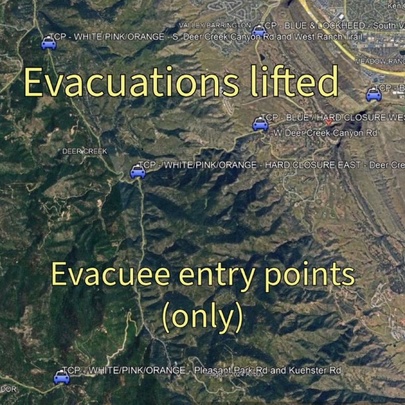
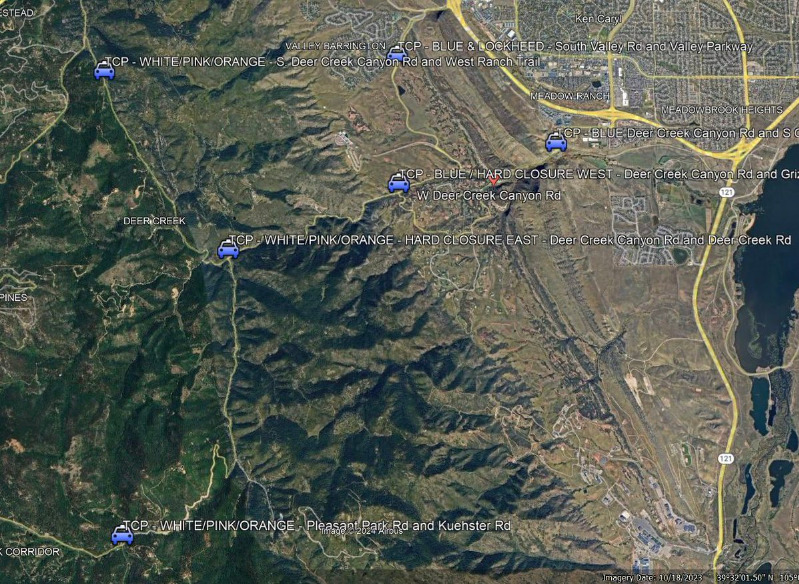
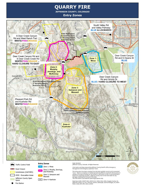
Last edit: 04 Aug 2024 14:40 by MountainTownAlerts. Reason: Added two maps with additional detail from JCSO
Please Log in or Create an account to join the conversation.
- MountainTownAlerts
-
 Topic Author
- Mountain Legend
-

Less
More
- Posts: 9704
- Thank you received: 220
04 Aug 2024 18:38 #62
by MountainTownAlerts
Replied by MountainTownAlerts on topic #QuarryFire: Vegetation fire Homewood Park Ave and S Deer Creek Canyon Rd
Evening briefing from Jeffco Sheriff.
youtube.com/watch?v=Jx8nae_XvO4
youtube.com/watch?v=Jx8nae_XvO4
Please Log in or Create an account to join the conversation.
- MountainTownAlerts
-
 Topic Author
- Mountain Legend
-

Less
More
- Posts: 9704
- Thank you received: 220
04 Aug 2024 19:09 #63
by MountainTownAlerts
Replied by MountainTownAlerts on topic #QuarryFire: Vegetation fire Homewood Park Ave and S Deer Creek Canyon Rd
From Inter-Canyon Fire 3min ago
"Containment"
The #QuarryFire is now at 35% containment.
Earlier today, West Metro Fire Rescue showed us a great video about why containment can seem to take a while. Here is some more info about exactly what that word means in the world of wildland fire...
One phrase you always listen for when following updates on a wildfire is "the fire is (x) percent contained." A 95% contained fire sounds a lot less scary than a 5% contained fire, but what exactly does containment mean?
Containment is when a section of control line is reasonably expected to stop the fire’s spread. The percent of containment indicates how much of the fire perimeter is considered contained. Rather than describing how much of the entire fire has been controlled or is “out”, containment refers solely to the perimeter itself.
(On many wildfire maps, a red color around the edge will indicate uncontained fire perimeter, and black will indicate contained.)
Even when there has been no fire at the edge of the perimeter for a while, fire managers are not likely to say a part of the perimeter is contained until the area is considered “cold”. Fire personnel and infrared-capable aircraft assess the fire’s edge regularly. When no heat is found for some time – sometimes multiple days – a certain part of the fire can be declared contained.
Containment builds on the scaffolding of days, weeks, or sometimes months of control line work. Crews have likely performed extensive hazardous fuels reduction, removing flammable vegetation by cutting, sawing, and by digging down to bare soil either by hand or with a bulldozer. Firefighters may also have conducted strategic burning operations to remove fuel from the fire’s path.
It's important to note that containment does not mean a fire is out, or that the danger has completely passed. As containment increases, sometimes roads may remain closed, or evacuations may remain in place. The fire itself may still burn within the interior for many weeks, and the containment percentage doesn’t always correlate to safety level within the fire area. Closures often remain in place long after containment is reached to keep the public safe and to give the land a chance to heal.
A note on remote or wilderness fires: Not every fire will be 100% contained. Containment is focused near values at risk or where fire is likely to grow and spread toward values at risk. However, if all or part of a fire is burning in inaccessible wilderness, it may never be fully “contained” by firefighters. Rather, the fire will diminish and eventually halt with a season ending weather event. Only then will it be considered “out.”
Please Log in or Create an account to join the conversation.
- ElkCreekFireDepartment
-
- Mountain Legend
-

04 Aug 2024 22:24 #64
by ElkCreekFireDepartment
In case of emergency, please dial 911.
elkcreekfpd.colorado.gov/
Facebook Page
Twitter
Instagram
303-816-9385 (Office Hours M-F 8:00-4:30)
This email address is being protected from spambots. You need JavaScript enabled to view it.
Replied by ElkCreekFireDepartment on topic #QuarryFire: Vegetation fire Homewood Park Ave and S Deer Creek Canyon Rd
SMOKE:
We have gotten reports that smoke is drifting down valley and into neighborhoods to the north and east of the #QuarryFire, including into neighboring districts / areas such as Ken Caryl Valley and Ken Caryl Ranch. Please be aware that smoke can settle more heavily during certain times of the day, and dispersal can change with changing weather patterns.
Smoke can cause health impacts, especially to sensitive populations. Please go here for excellent resources on smoke, including a smoke and air quality map: www.airnow.gov/wildfires/
In case of emergency, please dial 911.
elkcreekfpd.colorado.gov/
Facebook Page
303-816-9385 (Office Hours M-F 8:00-4:30)
This email address is being protected from spambots. You need JavaScript enabled to view it.
Please Log in or Create an account to join the conversation.
- MountainTownAlerts
-
 Topic Author
- Mountain Legend
-

Less
More
- Posts: 9704
- Thank you received: 220
05 Aug 2024 20:08 #65
by MountainTownAlerts
Replied by MountainTownAlerts on topic #QuarryFire: Vegetation fire Homewood Park Ave and S Deer Creek Canyon Rd
Jeffco Sheriff 3hrs ago
#QuarryFire update:
- 527 acres
- 45% containment
From Elk Creek Fire this morning:
QUARRY FIRE UPDATE
8-5-24, 9:00am
472 acres, 35% containment
Resources: 190 firefighters, one Type 1 helicopter, one Type 2 helicopter, one Type 3 helicopter, 13 engines
Fire and Operations:
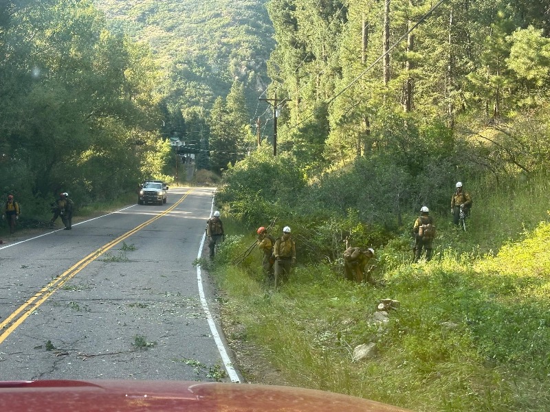
The Elk Creek Wildland Fire Module (WFM) performed strategic burning operations late into the night along S. Deer Creek Canyon Road, while the Inyo Hotshots successfully held fire at the road. Rain did slow some operations, but a significant amount was accomplished. These strategic burning operations will continue this morning, with plans to start around 10am, conditions allowing. Helicopters will support these operations. Smoke or flames may be visible.
REMEMBER, IF YOU FLY, WE CANNOT. All air operations will cease if there is a public drone in the air.
(In the photos included here, crews continue prepping the road/roadside for more of these burning operations.)
Weather:
Today (Monday, Aug 5) will be a little cooler and wetter, with minimum humidity only falling to 20% and maximum temperatures 91-95F. Winds predicted from the north and northwest at 4-12mph. Scattered showers and thunderstorms may develop during the afternoon into the night. Overnight humidity recoveries should be in the 60 to 70 percents.
LONG TERM DISCUSSION: Tuesday through Friday - Increasing moisture will allow for scattered afternoon showers and thunderstorms each afternoon this week, especially for the higher terrain. Storms may move off the higher elevations, but with dry lower levels, little rainfall is expected until the second half of the week. Thursday will bring cooler temperatures with greater chances for widespread wetting rains. Relative humidities are expected to remain above critical fire weather thresholds through the week.
Please Log in or Create an account to join the conversation.
- MountainTownAlerts
-
 Topic Author
- Mountain Legend
-

Less
More
- Posts: 9704
- Thank you received: 220
06 Aug 2024 09:36 #66
by MountainTownAlerts
Replied by MountainTownAlerts on topic #QuarryFire: Vegetation fire Homewood Park Ave and S Deer Creek Canyon Rd
Jeffco Sheriff 9:30am
#QuarryFire update:
•2pm press conference cancelled.
•GOOD NEWS! Effective 10 a.m. today all mandatory evacuations will be lifted.
•All residents must have access credentials issued at the evacuation center located at Dakota Ridge High School, located at 13399 W. Coal Mine Ave.
•Current mandatory evacuation neighborhoods will be move to pre-evacuation status.
•Current pre-evacuation neighborhoods will be moved to non-status.
•Only residents with access cards will be allowed for the next two days. General access will not be allowed until Thursday.
•Deer Creek Canyon Rd. will remain closed between Grizzly Dr. and Phillipsberg for several days for final clean up.
For more information about returning home:
www.jeffco.us/4824/Resources-for-Returning-Home#
Please Log in or Create an account to join the conversation.
- ElkCreekFireDepartment
-

- Mountain Legend
-

06 Aug 2024 10:10 #67
by ElkCreekFireDepartment
In case of emergency, please dial 911.
elkcreekfpd.colorado.gov/
Facebook Page
Twitter
Instagram
303-816-9385 (Office Hours M-F 8:00-4:30)
This email address is being protected from spambots. You need JavaScript enabled to view it.
Replied by ElkCreekFireDepartment on topic #QuarryFire: Vegetation fire Homewood Park Ave and S Deer Creek Canyon Rd
QUARRY FIRE UPDATE
8-6-24, 9:30am
572 acres, 45% containment
Resources: 192 personnel, one Type 1 helicopter, one Type 2 helicopter, 14 engines, 1 dozer
(Photos from operations on 8-5-24)
Fire:
Moderating temperatures and increasing relative humidity have reduced fire activity compared to prior days. Fire behavior remains moderate with backing behavior and some isolated torching. The fire is now 45% contained, and this containment is along most of the east perimeter. Residents will likely still see smoke, and weather dependent (if an inversion sets up), heavy smoke could settle into the canyon.
Operations:
Yesterday’s aerial ignitions were successful, assisting in continued efforts to secure the Deer Creek Canyon and Deer Creek Road area. A helicopter worked its way from the top of the ridge, down to the road, where firefighters continued with hand (drip torch) ignitions. The helicopter was able to get to areas that would be very difficult and dangerous for firefighters to access, considering the steep, rocky terrain. Fire managers are assessing the area, and, only if needed, there could be more hand ignitions to clean up any small amounts of still-unburned fuels near the control lines.
Today, crews on the south side of the fire will continue to mop-up and secure the fire line. On the west side, crews will mop-up “two chains” (or 132 feet) past the perimeter of the fire area, terrain allowing. Firefighters will also begin chipping operations along Deer Creek Canyon Road to remove slash that was cut during preparation for burning operations.
(Stay tuned later today for some more in-depth information on what “mop-up” means.)
Weather:
Today’s weather looks similar to Monday’s, with a round of showers and thunderstorms in the late afternoon and evening. There may be more of a risk of heavy rain with today’s storms. Max temps should be 86F, with minimum humidity of 32%. Southwest winds 5 to 7 mph until 0900, then becoming east to southeast 6 to 12 mph by 1200. Gusty and erratic winds expected near thunderstorms after 1200.
EXTENDED FORECAST: Temperatures will become cooler as the week progresses, moving from the upper 80s to the mid 70s, with chances of storms increasing. While wetting rains are possible through Wednesday, amounts will likely be closer to a tenth of an inch. There’s a good chance of more significant rainfall on Thursday and Friday.
Updates from Jefferson County re: Evacuations
(Also note that the 2pm press conference has been cancelled):
• Effective 10 a.m. today all mandatory evacuations will be lifted.
• All residents must have access credentials issued at the evacuation center located at Dakota Ridge High School, located at 13399 W. Coal Mine Ave.
• Current mandatory evacuation neighborhoods will be move to pre-evacuation status.
• Current pre-evacuation neighborhoods will be moved to non-status.
• Only residents with access cards will be allowed for the next two days. General access will not be allowed until Thursday.
• Deer Creek Canyon Rd. will remain closed between Grizzly Dr. and Phillipsberg for several days for final clean up.
For more information about returning home:
www.jeffco.us/4824/Resources-for-Returning-Home#
In case of emergency, please dial 911.
elkcreekfpd.colorado.gov/
Facebook Page
303-816-9385 (Office Hours M-F 8:00-4:30)
This email address is being protected from spambots. You need JavaScript enabled to view it.
Please Log in or Create an account to join the conversation.
- MountainTownAlerts
-
 Topic Author
- Mountain Legend
-

Less
More
- Posts: 9704
- Thank you received: 220
06 Aug 2024 16:44 #68
by MountainTownAlerts
Replied by MountainTownAlerts on topic #QuarryFire: Vegetation fire Homewood Park Ave and S Deer Creek Canyon Rd
@jeffco Sheriff 20min ago
#QuarryFire:
-578 acres
-82% containment!!
Jeffco Sheriff earlier afternoon updates:
-The evacuation center will be open for badges until 6pm. After that it will be permanently closed.
-The large animal evacuation site at Jeffco Fairgrounds asks that those no longer in pre-evacuation status make arrangements to pick up their animals from the Jeffco Fairgrounds. If you are now in pre-evacuation you may keep your animals at the fairgrounds until your status has changed.
Welcome home to our evacuees! Here is an updated map of the checkpoints and the color coded credentials to get you past the road blocks. The checkpoints will be there for at least 48 hours. Deer Creek Canyon Road remains closed at South Deer Creek Road and Grizzly Drive. #QuarryFire
@JeffcoColorado 12:38pm
We are no longer accepting donations of any kind. Thank you to the Jefferson County community and surrounding communities for your overwhelming support. #QuarryFire
Please Log in or Create an account to join the conversation.
- MountainTownAlerts
-
 Topic Author
- Mountain Legend
-

Less
More
- Posts: 9704
- Thank you received: 220
09 Aug 2024 21:25 - 09 Aug 2024 21:34 #69
by MountainTownAlerts
Replied by MountainTownAlerts on topic #QuarryFire: Vegetation fire Homewood Park Ave and S Deer Creek Canyon Rd
There was a small 4’ x 4’ flare up reported in the Quarry Fire area. Inter-Canyon investigated and determined it was not unexpected and well within the containment lines. They will leave it for tonight and continue monitoring the area.
The fire was declared 100% contained on Wednesday afternoon. Per Jeffco Sheriff:
#QuarryFire update:
- 100% containment
- 579.6 acres
- All pre-evacuations lifted
- All road closures will open at 10 a.m. Thursday
From West Metro Fire 8/7:
The #QuarryFire is 100% contained. That does not mean that you will no longer see smoke from the fire. Containment itself refers to a barrier, whether it be natural or manmade, that prevents a wildfire from spreading. Manmade barriers can refer to fireline dug by crews or by heavy machinery such as dozers. Inside the fire's perimeter- however- there are still smoldering pockets of fuel. Heavy, large diameter fuels and tree stumps can hold heat for quite some time. Containment means that crews are confident the fire will not spread beyond the containment line. But, those smoldering pockets of fuel may produce smoke, even flames, especially on hot, sunny days. Know that this is typical fire behavior.
Update 8/8 from Inter-Canyon Fire:
QUARRY FIRE, 8-8-24, 12:00pm
Command of the #QuarryFire will be transitioned back to the local unit today. We will continue to post updates, but they will be shorter and less frequent. While the fire is 100% contained, there is still much work to do. The fire remains staffed, and our firefighters will be diligently working on the Quarry Fire for some time to come. Residents should know that they may still see smoke in the air. Large timber will continue smoldering in the fire's interior.
QUARRY FIRE, 8-9-24, 4pm
Yesterday, Command of the #QuarryFire was transferred from the Jefferson County Incident Management Team to the Elk Creek Wildland Fire Module with Incident Commander Jayson Papenfus and Billy Gage as Incident Commander Trainee.
Due to an increase in moisture, the fire no longer needs continual staffing, but will be monitored and patrolled daily over the coming weeks. There may be several smokes visible high on the slopes uphill from Deer Creek Canyon Rd. These are all interior burning and are not a containment concern. These smokes could be visible over the coming weeks.
Last edit: 09 Aug 2024 21:34 by MountainTownAlerts.
Please Log in or Create an account to join the conversation.
- ElkCreekFireDepartment
-

- Mountain Legend
-

13 Aug 2024 16:37 #70
by ElkCreekFireDepartment
In case of emergency, please dial 911.
elkcreekfpd.colorado.gov/
Facebook Page
Twitter
Instagram
303-816-9385 (Office Hours M-F 8:00-4:30)
This email address is being protected from spambots. You need JavaScript enabled to view it.
Replied by ElkCreekFireDepartment on topic #QuarryFire: Vegetation fire Homewood Park Ave and S Deer Creek Canyon Rd
QUARRY FIRE UPDATE, Tuesday, August 13, 2024, 12pm
On Saturday, August 10th, command of the #QuarryFire was transferred back to Inter-Canyon Fire Protection District. The fire has been receiving moisture every day since then, and containment remains at 100%. The fire is being patrolled and monitored.
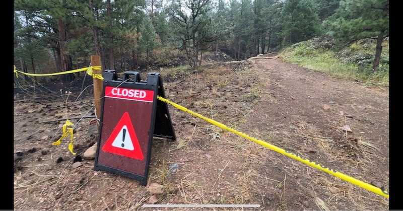
(Photo: Closed area of dozer line built during Quarry Fire operations to protect Sampson neighborhood.)
In case of emergency, please dial 911.
elkcreekfpd.colorado.gov/
Facebook Page
303-816-9385 (Office Hours M-F 8:00-4:30)
This email address is being protected from spambots. You need JavaScript enabled to view it.
Please Log in or Create an account to join the conversation.
- Forum
- Life Up the Hill
- Scanner & Emergency Info, Weather Forecasts
- #QuarryFire: Vegetation fire Homewood Park Ave and S Deer Creek Canyon Rd
Time to create page: 0.308 seconds

