- Posts: 9766
- Thank you received: 221
- Forum
- Life Up the Hill
- Scanner & Emergency Info, Weather Forecasts
- Today's NOAA Weather Map Forecast
Today's NOAA Weather Map Forecast
- MountainTownAlerts
-
 Topic Author
- Mountain Legend
-

Less
More
15 Feb 2013 08:48 #51
by MountainTownAlerts
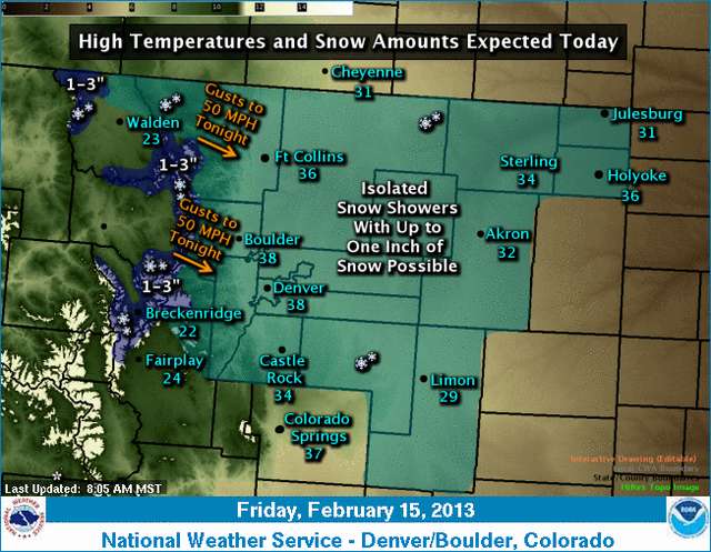
Light snow will continue across the high country today...with a few snow showers possible across the plains. Northwest winds will increase in the higher mountains and front range foothills this evening...with gusts to 50 mph possible.
Replied by MountainTownAlerts on topic Today's NOAA Weather Map Forecast

Light snow will continue across the high country today...with a few snow showers possible across the plains. Northwest winds will increase in the higher mountains and front range foothills this evening...with gusts to 50 mph possible.
Please Log in or Create an account to join the conversation.
- MountainTownAlerts
-
Topic Author
- Mountain Legend
-
Less
More
- Posts: 9766
- Thank you received: 221
17 Feb 2013 13:54 #52
by MountainTownAlerts

Warm and gusty westerly winds ahead of an approaching cold front will bring above normal temperatures and very dry air to the front range of Colorado. This pattern will produce high fire danger from the northern front range foothills down through metro Denver and into the Palmer Divide. Gusty winds to 50 mph will be possible across the higher mountains and front range foothills with 1 to 4 inches possible across the high country tonight.
Replied by MountainTownAlerts on topic Today's NOAA Weather Map Forecast

Warm and gusty westerly winds ahead of an approaching cold front will bring above normal temperatures and very dry air to the front range of Colorado. This pattern will produce high fire danger from the northern front range foothills down through metro Denver and into the Palmer Divide. Gusty winds to 50 mph will be possible across the higher mountains and front range foothills with 1 to 4 inches possible across the high country tonight.
Please Log in or Create an account to join the conversation.
- MountainTownAlerts
-
Topic Author
- Mountain Legend
-
Less
More
- Posts: 9766
- Thank you received: 221
03 Mar 2013 07:54 #53
by MountainTownAlerts

Snow and blowing snow will develop and spread eastward across the mountains this afternoon and early evening. The snow and blowing snow will create hazardous and slow travel conditions in the high country. Visibilities will likely be reduced to one quarter mile or less at times shortly after the onset of snow. Accumulations by daybreak Monday are expected to range between 4 and 8 inches in most mountain locations.
Over the foothills and plains, gusty winds in and near the foothills will spread across most of the plains this afternoon.
Dry conditions will prevail until late tonight when the passage of a cold front will bring a chance of snow showers down into the lower elevations. A fast moving upper level disturbance across the Northern Rockies will produce the gusty winds and snowfall.
http://www.crh.noaa.gov/bou
Replied by MountainTownAlerts on topic Today's NOAA Weather Map Forecast

Snow and blowing snow will develop and spread eastward across the mountains this afternoon and early evening. The snow and blowing snow will create hazardous and slow travel conditions in the high country. Visibilities will likely be reduced to one quarter mile or less at times shortly after the onset of snow. Accumulations by daybreak Monday are expected to range between 4 and 8 inches in most mountain locations.
Over the foothills and plains, gusty winds in and near the foothills will spread across most of the plains this afternoon.
Dry conditions will prevail until late tonight when the passage of a cold front will bring a chance of snow showers down into the lower elevations. A fast moving upper level disturbance across the Northern Rockies will produce the gusty winds and snowfall.
http://www.crh.noaa.gov/bou
Please Log in or Create an account to join the conversation.
- MountainTownAlerts
-
Topic Author
- Mountain Legend
-
Less
More
- Posts: 9766
- Thank you received: 221
22 Mar 2013 11:47 #54
by MountainTownAlerts

Scattered snow showers will develop over the mountains this
afternoon and become widespread this evening. Snow will also
spread over the lower elevations this evening and becoming heavy
at times later tonight and Saturday. A storm system over the
Pacific northwest will move into northwest Colorado by later
tonight which will bring the snow and colder temperatures.
Replied by MountainTownAlerts on topic Today's NOAA Weather Map Forecast

Scattered snow showers will develop over the mountains this
afternoon and become widespread this evening. Snow will also
spread over the lower elevations this evening and becoming heavy
at times later tonight and Saturday. A storm system over the
Pacific northwest will move into northwest Colorado by later
tonight which will bring the snow and colder temperatures.
Please Log in or Create an account to join the conversation.
- MountainTownAlerts
-
Topic Author
- Mountain Legend
-
Less
More
- Posts: 9766
- Thank you received: 221
23 Mar 2013 08:57 #55
by MountainTownAlerts

Snow will continue through most of today and will be heavy at times on the eastern plains. Winds will also increase with gusts as high as 45 mph producing considerable blowing and drifting snow and near blizzard conditions east of Denver. The snow is expected to gradually taper off in intensity by the mid to late afternoon hours. Total snow accumulations will range from 3 to 7 inches in the Fort Collins and Greeley corridor, to 6 to 12 inches in the Denver/Boulder area and I-76 corridor to Nebraska, with 10 to 16 inches from the eastern portions of Adams and Arapahoe counties into southern Morgan, Washington, and northern Lincoln counties. Mountain and foothill locations will see 6 to 12 inch amounts with the heavier totals in the foothills, while totals in high mountain valleys should generally range between 2 and 6 inches. Temperatures will be very cold tonight with single digit lows on the plains and below zero readings in the high country.
Replied by MountainTownAlerts on topic Today's NOAA Weather Map Forecast

Snow will continue through most of today and will be heavy at times on the eastern plains. Winds will also increase with gusts as high as 45 mph producing considerable blowing and drifting snow and near blizzard conditions east of Denver. The snow is expected to gradually taper off in intensity by the mid to late afternoon hours. Total snow accumulations will range from 3 to 7 inches in the Fort Collins and Greeley corridor, to 6 to 12 inches in the Denver/Boulder area and I-76 corridor to Nebraska, with 10 to 16 inches from the eastern portions of Adams and Arapahoe counties into southern Morgan, Washington, and northern Lincoln counties. Mountain and foothill locations will see 6 to 12 inch amounts with the heavier totals in the foothills, while totals in high mountain valleys should generally range between 2 and 6 inches. Temperatures will be very cold tonight with single digit lows on the plains and below zero readings in the high country.
Please Log in or Create an account to join the conversation.
- MountainTownAlerts
-
Topic Author
- Mountain Legend
-
Less
More
- Posts: 9766
- Thank you received: 221
07 Apr 2013 12:48 #56
by MountainTownAlerts

For today and tonight:
There will be light snow shower activity over the high country
with a slight chance of rain showers across the eastern plains
this afternoon and early evening.
For Monday through Saturday:
A strong storm system over the Great Basin will produce a variety
of weather across the region beginning Monday afternoon. Scattered
thunderstorms, some possibly strong, may develop ahead of this
system Monday afternoon over the northeast plains. The biggest
threat at this point looks to be hail and strong winds, but an
isolated tornado or two may occur due to strong low level shear.
As the main storm center moves into the four corners area, this
storm has the potential to bring heavy snow to the
mountains, foothills and adjacent plains Monday night into
Tuesday if it tracks eastward into southeast Colorado by Tuesday.
If this does occur, snowfall amounts of 6-12 inches with higher
amounts could fall over the area, with the heaviest snowfall
expected in the foothills and along the Front Range Urban
Corridor. Strong northerly winds of 15 to 25 mph with gusts as
high as 40 mph will create hazardous driving conditions in blowing
snow late Monday night through Tuesday especially along and east
of I-25. The exact track of this storm is still remains uncertain
so stay tuned for updates on this potential early spring storm.
Spotter activation will not be needed today or tonight.
Replied by MountainTownAlerts on topic Today's NOAA Weather Map Forecast

For today and tonight:
There will be light snow shower activity over the high country
with a slight chance of rain showers across the eastern plains
this afternoon and early evening.
For Monday through Saturday:
A strong storm system over the Great Basin will produce a variety
of weather across the region beginning Monday afternoon. Scattered
thunderstorms, some possibly strong, may develop ahead of this
system Monday afternoon over the northeast plains. The biggest
threat at this point looks to be hail and strong winds, but an
isolated tornado or two may occur due to strong low level shear.
As the main storm center moves into the four corners area, this
storm has the potential to bring heavy snow to the
mountains, foothills and adjacent plains Monday night into
Tuesday if it tracks eastward into southeast Colorado by Tuesday.
If this does occur, snowfall amounts of 6-12 inches with higher
amounts could fall over the area, with the heaviest snowfall
expected in the foothills and along the Front Range Urban
Corridor. Strong northerly winds of 15 to 25 mph with gusts as
high as 40 mph will create hazardous driving conditions in blowing
snow late Monday night through Tuesday especially along and east
of I-25. The exact track of this storm is still remains uncertain
so stay tuned for updates on this potential early spring storm.
Spotter activation will not be needed today or tonight.
Please Log in or Create an account to join the conversation.
- MountainTownAlerts
-
Topic Author
- Mountain Legend
-
Less
More
- Posts: 9766
- Thank you received: 221
08 Apr 2013 12:42 #57
by MountainTownAlerts

A very dynamic and complex system will begin to affect us this afternoon! Expecting convection to begin over northeastern Colorado early this afternoon, with some severe strength storms possible toward the CO/KS border.
The strong cold front, currently up in Wyoming, will plow south tonight changing rain to snow. We have upgraded the Winter Storm Watch to Warnings, including to Blizzard Warnings for the strong north winds expected tomorrow. Still some uncertainty out far east so kept the Watch.
Keep updated with our latest forecasts and information as this storm progresses!
Replied by MountainTownAlerts on topic Today's NOAA Weather Map Forecast

A very dynamic and complex system will begin to affect us this afternoon! Expecting convection to begin over northeastern Colorado early this afternoon, with some severe strength storms possible toward the CO/KS border.
The strong cold front, currently up in Wyoming, will plow south tonight changing rain to snow. We have upgraded the Winter Storm Watch to Warnings, including to Blizzard Warnings for the strong north winds expected tomorrow. Still some uncertainty out far east so kept the Watch.
Keep updated with our latest forecasts and information as this storm progresses!
Please Log in or Create an account to join the conversation.
- MountainTownAlerts
-
Topic Author
- Mountain Legend
-
Less
More
- Posts: 9766
- Thank you received: 221
23 May 2013 13:06 #58
by MountainTownAlerts

Isolated thunderstorms will develop over the higher terrain of the mountains and Front Range foothills this afternoon. A few of these
storms may move onto the Urban Corridor by late afternoon. There is a low probability of an isolated severe storm over the Denver area with brief large hail up to one inch in diameter along with brief tornados.
There is a Denver cyclone today with a convergence boundary oriented from near littleton and stretching northward through Denver and into southwest Weld county. If enough heating can occur then storm initiation would develop along the boundary. Further east on the plains, the airmass is too stable for storms today.
http://www.crh.noaa.gov/bou/
Replied by MountainTownAlerts on topic Today's NOAA Weather Map Forecast

Isolated thunderstorms will develop over the higher terrain of the mountains and Front Range foothills this afternoon. A few of these
storms may move onto the Urban Corridor by late afternoon. There is a low probability of an isolated severe storm over the Denver area with brief large hail up to one inch in diameter along with brief tornados.
There is a Denver cyclone today with a convergence boundary oriented from near littleton and stretching northward through Denver and into southwest Weld county. If enough heating can occur then storm initiation would develop along the boundary. Further east on the plains, the airmass is too stable for storms today.
http://www.crh.noaa.gov/bou/
Please Log in or Create an account to join the conversation.
- MountainTownAlerts
-
Topic Author
- Mountain Legend
-
Less
More
- Posts: 9766
- Thank you received: 221
25 Jun 2013 09:15 #59
by MountainTownAlerts

For today and tonight:
Another very warm and dry day can be expected with temperatures
several degrees above normal. Low humidity readings and breezy
conditions in the foothills of Larimer and Boulder counties will
lead to critical fire weather conditions there.
No thunderstorms will occur today as a very stable airmass spreads
across the state.
For Wednesday through Monday:
Hot and dry conditions will prevail across the outlook area
Wednesday and Thursday with the fire danger remaining elevated.
Slightly cooler conditions will return Friday through Sunday with
a slight chance of late day showers and thunderstorms.
Spotter activation will not be needed today or tonight.
http://www.crh.noaa.gov/wxstory.php?site=bou
Replied by MountainTownAlerts on topic Today's NOAA Weather Map Forecast

For today and tonight:
Another very warm and dry day can be expected with temperatures
several degrees above normal. Low humidity readings and breezy
conditions in the foothills of Larimer and Boulder counties will
lead to critical fire weather conditions there.
No thunderstorms will occur today as a very stable airmass spreads
across the state.
For Wednesday through Monday:
Hot and dry conditions will prevail across the outlook area
Wednesday and Thursday with the fire danger remaining elevated.
Slightly cooler conditions will return Friday through Sunday with
a slight chance of late day showers and thunderstorms.
Spotter activation will not be needed today or tonight.
http://www.crh.noaa.gov/wxstory.php?site=bou
Please Log in or Create an account to join the conversation.
- MountainTownAlerts
-
Topic Author
- Mountain Legend
-
Less
More
- Posts: 9766
- Thank you received: 221
29 Jun 2013 09:05 #60
by MountainTownAlerts

For today and tonight:
Scattered thunderstorms will develop by early afternoon in the
mountains, foothills and Palmer Divide. Outflow boundaries from
these storms will then lead to additional thunderstorm development
along the Front Range Urban Corridor by late afternoon into the
early evening hours. With a favorable shear profile in place a few
of the storms may become severe in and near the foothills and over
the Palmer Divide. Hail up to 1.5 inches in diameter along with
wind gusts to 60 mph will be possible. Some heavy rainfall may
also occur in the foothills which could lead to some flash
flooding in the high Park and four mile burn areas.
For Sunday through Friday:
An unsettled weather pattern will remain over northeast Colorado
through the end of next week. A persistent upper ridge over the
western United States will produce northerly flow aloft over
Colorado while surface high pressure over the northern and Central
Plains keeps moist upslope low level winds in place across the
eastern Colorado plains. Daytime heating each day will be
sufficient to de-stabilize the atmosphere and produce scattered
afternoon and evening thunderstorms. Some storms may become severe
with large hail and damaging winds. Periods of heavy rain will
also result. Storms will generally follow north to south paths.
Initial storm generation each day will be in and near the
foothills, but outflow boundaries from storms will be able to
generate additional showers across the plains each evening.
Temperatures will be around seasonal normals and the rainfall will
help to ease fire weather concerns.
Spotter activation may be needed after 3 PM along the Front Range.
http://www.crh.noaa.gov/bou/
Replied by MountainTownAlerts on topic Today's NOAA Weather Map Forecast

For today and tonight:
Scattered thunderstorms will develop by early afternoon in the
mountains, foothills and Palmer Divide. Outflow boundaries from
these storms will then lead to additional thunderstorm development
along the Front Range Urban Corridor by late afternoon into the
early evening hours. With a favorable shear profile in place a few
of the storms may become severe in and near the foothills and over
the Palmer Divide. Hail up to 1.5 inches in diameter along with
wind gusts to 60 mph will be possible. Some heavy rainfall may
also occur in the foothills which could lead to some flash
flooding in the high Park and four mile burn areas.
For Sunday through Friday:
An unsettled weather pattern will remain over northeast Colorado
through the end of next week. A persistent upper ridge over the
western United States will produce northerly flow aloft over
Colorado while surface high pressure over the northern and Central
Plains keeps moist upslope low level winds in place across the
eastern Colorado plains. Daytime heating each day will be
sufficient to de-stabilize the atmosphere and produce scattered
afternoon and evening thunderstorms. Some storms may become severe
with large hail and damaging winds. Periods of heavy rain will
also result. Storms will generally follow north to south paths.
Initial storm generation each day will be in and near the
foothills, but outflow boundaries from storms will be able to
generate additional showers across the plains each evening.
Temperatures will be around seasonal normals and the rainfall will
help to ease fire weather concerns.
Spotter activation may be needed after 3 PM along the Front Range.
http://www.crh.noaa.gov/bou/
Please Log in or Create an account to join the conversation.
- Forum
- Life Up the Hill
- Scanner & Emergency Info, Weather Forecasts
- Today's NOAA Weather Map Forecast
Time to create page: 0.204 seconds
sponsors


