- Posts: 9766
- Thank you received: 221
- Forum
- Life Up the Hill
- Scanner & Emergency Info, Weather Forecasts
- Today's NOAA Weather Map Forecast
Today's NOAA Weather Map Forecast
- MountainTownAlerts
-
 Topic Author
- Mountain Legend
-

Less
More
03 Nov 2014 10:41 #71
by MountainTownAlerts
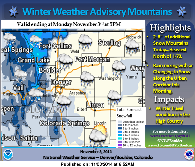
For today and tonight:
Snow is expected to continue in the mountains and foothills today
as an upper level weather system moves across Colorado. Rain and
snow will also spread across the northeast Colorado plains, with
the heaviest amounts of precipitation expected to be in Larimer
and Weld counties. Snowfall rates in the mountains will be
moderate at times this morning and rain or snow showers on the
plains may be moderate at times today. Snow accumulations up to 6
inches will be possible in the mountains today. Over the northern
I-25 corridor, rain showers changing to snow might produce an
inch or two of accumulation, but the snow is expected to melt
quickly after it stops falling.
The storm system will be moving out of the state by this evening
with precipitation ending on the plains and snowfall in the
mountains gradually decreasing. With clearing skies
overnight, temperatures on the plains are expected to drop well
below the freezing mark.
For Tuesday through Sunday:
It will be dry through the period except for a slight chance of
showers Friday night. Gusty winds will occur at times in the
mountains and foothills. Temperatures will be near normal through
Wednesday and then above normal for Thursday and Friday.
www.crh.noaa.gov/bou/
Replied by MountainTownAlerts on topic Today's NOAA Weather Map Forecast
For today and tonight:
Snow is expected to continue in the mountains and foothills today
as an upper level weather system moves across Colorado. Rain and
snow will also spread across the northeast Colorado plains, with
the heaviest amounts of precipitation expected to be in Larimer
and Weld counties. Snowfall rates in the mountains will be
moderate at times this morning and rain or snow showers on the
plains may be moderate at times today. Snow accumulations up to 6
inches will be possible in the mountains today. Over the northern
I-25 corridor, rain showers changing to snow might produce an
inch or two of accumulation, but the snow is expected to melt
quickly after it stops falling.
The storm system will be moving out of the state by this evening
with precipitation ending on the plains and snowfall in the
mountains gradually decreasing. With clearing skies
overnight, temperatures on the plains are expected to drop well
below the freezing mark.
For Tuesday through Sunday:
It will be dry through the period except for a slight chance of
showers Friday night. Gusty winds will occur at times in the
mountains and foothills. Temperatures will be near normal through
Wednesday and then above normal for Thursday and Friday.
www.crh.noaa.gov/bou/
Please Log in or Create an account to join the conversation.
- MountainTownAlerts
-
Topic Author
- Mountain Legend
-
Less
More
- Posts: 9766
- Thank you received: 221
23 Dec 2014 18:44 #72
by MountainTownAlerts
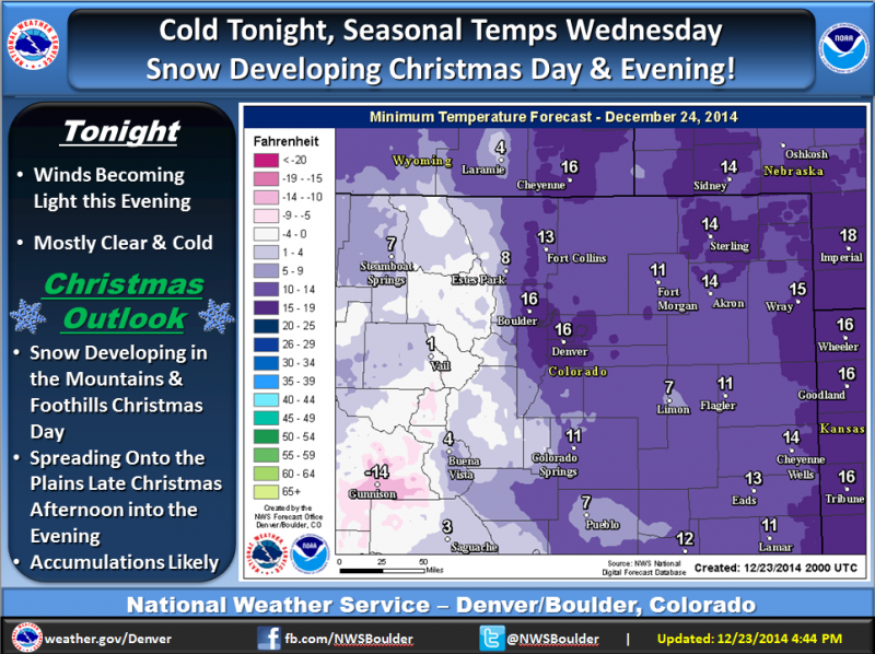
A cold night is expected with mostly clear skies and much lighter winds. Then temperatures will be slightly above normal for Wednesday and Christmas. However, snow will develop across the mountains and foothills during Christmas Day, and then spread onto the plains late Christmas afternoon through the evening! Most areas are expected to see accumulating snowfall with this weather disturbance and cold front moving into the state.
www.crh.noaa.gov/bou/
Replied by MountainTownAlerts on topic Today's NOAA Weather Map Forecast
A cold night is expected with mostly clear skies and much lighter winds. Then temperatures will be slightly above normal for Wednesday and Christmas. However, snow will develop across the mountains and foothills during Christmas Day, and then spread onto the plains late Christmas afternoon through the evening! Most areas are expected to see accumulating snowfall with this weather disturbance and cold front moving into the state.
www.crh.noaa.gov/bou/
Please Log in or Create an account to join the conversation.
- MountainTownAlerts
-
Topic Author
- Mountain Legend
-
Less
More
- Posts: 9766
- Thank you received: 221
28 Dec 2014 18:59 #73
by MountainTownAlerts
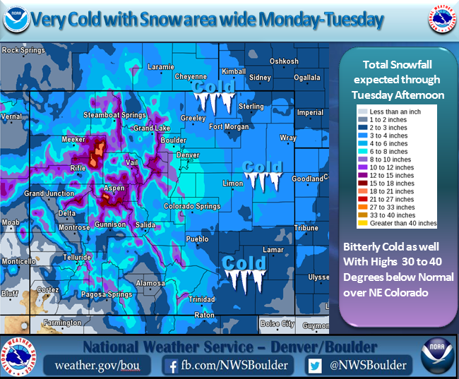
An arctic front air mass will affect northeast Colorado Monday and Tuesday bringing much colder temperatures along with periods of snow.
www.crh.noaa.gov/bou/
Replied by MountainTownAlerts on topic Today's NOAA Weather Map Forecast
An arctic front air mass will affect northeast Colorado Monday and Tuesday bringing much colder temperatures along with periods of snow.
www.crh.noaa.gov/bou/
Please Log in or Create an account to join the conversation.
- MountainTownAlerts
-
Topic Author
- Mountain Legend
-
Less
More
- Posts: 9766
- Thank you received: 221
08 Jan 2015 10:13 #74
by MountainTownAlerts
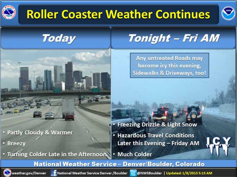
For today and tonight:
After a brief warmup, another shot of arctic air is expected to
reach northeast Colorado by mid to late afternoon. Temperatures
will drop with another round of light snow, freezing
drizzle, and fog for the plains and foothills. Hazardous travel
and icy road conditions may develop shortly after precipitation
begins this evening and remain in place through the night.
Untreated roads, sidewalks, and driveways will be especially
prone to ice accumulation and hazardous walking and driving.
For Friday through Wednesday:
Cold temperatures and some lingering light snow will prevail
through Friday as an upper level disturbance moves out of the
state. After a chilly start to the day on Saturday, temperatures
will warm to near seasonal normals by afternoon. Sunday will also
be dry but not as warm. Mountain areas may pick up an inch or two
of snow on Sunday as a weak upper level disturbance tracks across
the state. Cooler weather is in store for the plains early next
week as a cold front arrives Monday and an upper level disturbance
crossing the state Tuesday produces another chance of light snow
over the mountains and plains.
Spotter activation will not be needed today or tonight.
However, any reports of precipitation type will be appreciated.
www.crh.noaa.gov/bou/
Replied by MountainTownAlerts on topic Today's NOAA Weather Map Forecast
For today and tonight:
After a brief warmup, another shot of arctic air is expected to
reach northeast Colorado by mid to late afternoon. Temperatures
will drop with another round of light snow, freezing
drizzle, and fog for the plains and foothills. Hazardous travel
and icy road conditions may develop shortly after precipitation
begins this evening and remain in place through the night.
Untreated roads, sidewalks, and driveways will be especially
prone to ice accumulation and hazardous walking and driving.
For Friday through Wednesday:
Cold temperatures and some lingering light snow will prevail
through Friday as an upper level disturbance moves out of the
state. After a chilly start to the day on Saturday, temperatures
will warm to near seasonal normals by afternoon. Sunday will also
be dry but not as warm. Mountain areas may pick up an inch or two
of snow on Sunday as a weak upper level disturbance tracks across
the state. Cooler weather is in store for the plains early next
week as a cold front arrives Monday and an upper level disturbance
crossing the state Tuesday produces another chance of light snow
over the mountains and plains.
Spotter activation will not be needed today or tonight.
However, any reports of precipitation type will be appreciated.
www.crh.noaa.gov/bou/
Please Log in or Create an account to join the conversation.
- MountainTownAlerts
-
Topic Author
- Mountain Legend
-
Less
More
- Posts: 9766
- Thank you received: 221
15 Feb 2015 07:33 #75
by MountainTownAlerts
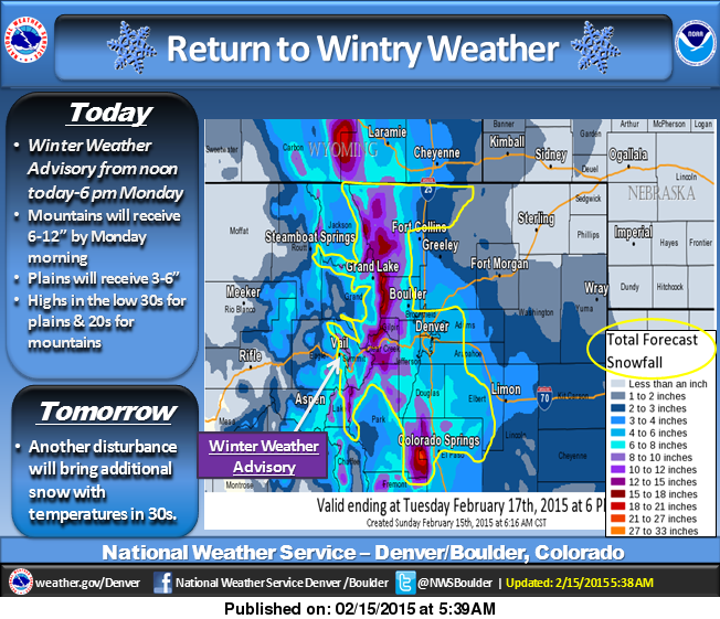
For today and tonight:
A cold front will push south across northeast Colorado this
morning. It will be much colder today behind the cold front. Snow
is expected to spread south across northeast Colorado this
afternoon and evening. Roads are expected to become snow covered
and slippery late this afternoon and evening as temperatures
cool. If traveling this afternoon or tonight, allow extra time to
reach your destination.
For Monday through Saturday:
The passage of an upper level trough, cold front and jet stream
will bring more snow and colder temperatures to the forecast area
on Monday. The greatest snowfall is likely to occur in and along
the Front Range where several inches of snow may accumulate by
Monday evening. Farther out on the plains snow amounts will be
much less although this same area could see some light snow
accumulation on Tuesday with a passing jet stream. People planning
travel into the high country and along the Interstate 25 corridor
on Monday, Washington's birthday, should prepare for difficult
winter driving conditions. Roads in these areas will likely be icy
and snow covered and passage over the high mountain passes may
require tire chains or adequate snow tires. Snowfall on the plains
should decrease Monday evening and in the high country during the
day Tuesday. Another weather system dropping down from Montana
may bring more snow and cold to the outlook area by late in the
week.
Spotter activation will not be needed tonight.
www.crh.noaa.gov/wxstory.php?site=bou
Replied by MountainTownAlerts on topic Today's NOAA Weather Map Forecast
For today and tonight:
A cold front will push south across northeast Colorado this
morning. It will be much colder today behind the cold front. Snow
is expected to spread south across northeast Colorado this
afternoon and evening. Roads are expected to become snow covered
and slippery late this afternoon and evening as temperatures
cool. If traveling this afternoon or tonight, allow extra time to
reach your destination.
For Monday through Saturday:
The passage of an upper level trough, cold front and jet stream
will bring more snow and colder temperatures to the forecast area
on Monday. The greatest snowfall is likely to occur in and along
the Front Range where several inches of snow may accumulate by
Monday evening. Farther out on the plains snow amounts will be
much less although this same area could see some light snow
accumulation on Tuesday with a passing jet stream. People planning
travel into the high country and along the Interstate 25 corridor
on Monday, Washington's birthday, should prepare for difficult
winter driving conditions. Roads in these areas will likely be icy
and snow covered and passage over the high mountain passes may
require tire chains or adequate snow tires. Snowfall on the plains
should decrease Monday evening and in the high country during the
day Tuesday. Another weather system dropping down from Montana
may bring more snow and cold to the outlook area by late in the
week.
Spotter activation will not be needed tonight.
www.crh.noaa.gov/wxstory.php?site=bou
Please Log in or Create an account to join the conversation.
- Forum
- Life Up the Hill
- Scanner & Emergency Info, Weather Forecasts
- Today's NOAA Weather Map Forecast
Time to create page: 0.223 seconds
sponsors


