- Posts: 46
- Thank you received: 14
Local Foothills Weather Forecasts
- Chief Meteorologist
-
 Topic Author
- Happy Camper
-

Less
More
01 Nov 2015 17:28 #71
by Chief Meteorologist
Replied by Chief Meteorologist on topic Local Foothills Weather Forecasts
The upcoming rain/snow ain't gonna be a big deal. This one is coming in from the NW, and the eastern slopes and foothills usually don't benefit from these types of arrangements.
We will have another small system coming through on Thursday; again, not a big deal. Still waiting for the big southwestern storms to start coming, but that does not look favorable until mid-November.
- Meteorologist Steve
We will have another small system coming through on Thursday; again, not a big deal. Still waiting for the big southwestern storms to start coming, but that does not look favorable until mid-November.
- Meteorologist Steve
The following user(s) said Thank You: ScienceChic
Please Log in or Create an account to join the conversation.
- HappyCamper
-

- Mountain Legend
-

Less
More
- Posts: 1810
- Thank you received: 98
02 Nov 2015 06:23 #72
by HappyCamper
Replied by HappyCamper on topic Local Foothills Weather Forecasts
Good to hear Thursday will not be a big deal as I need to take my Mom to the Dr. that day.
Please Log in or Create an account to join the conversation.
- HappyCamper
-
- Mountain Legend
-
Less
More
- Posts: 1810
- Thank you received: 98
13 Nov 2015 12:46 #73
by HappyCamper
Replied by HappyCamper on topic Local Foothills Weather Forecasts
So Steve, what do you think about next week I am seeing snowflakes on the extended forecast?
By the way Congrats on being back on the radio.
By the way Congrats on being back on the radio.
Please Log in or Create an account to join the conversation.
- Chief Meteorologist
-
Topic Author
- Happy Camper
-
Less
More
- Posts: 46
- Thank you received: 14
13 Nov 2015 13:44 #74
by Chief Meteorologist
Replied by Chief Meteorologist on topic Local Foothills Weather Forecasts
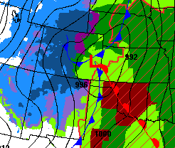
Well, the deal with Monday night and Tuesday is very uncertain at this point. We use four major weather models to help us "play out" the scenarios, and one of the models is way out there, showing us a lot of snow. The other three say "no big deal".
This is one of those times where we will have to wait a few more hours to see which models come into alignment. There is a fair chance of us ending up with a storm much like the last one, with a few inches of snow and colder weather. The model that is giving us weird returns right now says we will get a major snow event. This is certainly possible, but unlikely.
I will, of course keep watching. Each model is run every 12 hours, except for the short-range which is every hour, but only goes out one day.
Gotta keep an eye on it and give you an update when we know more.
- Steve
Please Log in or Create an account to join the conversation.
- HappyCamper
-
- Mountain Legend
-
Less
More
- Posts: 1810
- Thank you received: 98
15 Nov 2015 09:01 #75
by HappyCamper
Replied by HappyCamper on topic Local Foothills Weather Forecasts
So do you agree with 9 News they are saying 9 1/2 inches for Bailey?
Do you know where they consider Bailey? I that at the bottom of Crow Hill or do they just have someone they get stats from up here?
Thanks
Do you know where they consider Bailey? I that at the bottom of Crow Hill or do they just have someone they get stats from up here?
Thanks
Please Log in or Create an account to join the conversation.
- Chief Meteorologist
-
Topic Author
- Happy Camper
-
Less
More
- Posts: 46
- Thank you received: 14
15 Nov 2015 09:19 #76
by Chief Meteorologist
Replied by Chief Meteorologist on topic Local Foothills Weather Forecasts
I'm not comparing our forecasts to anyone else, but in general we can say Bailey will get "up to a foot" of new snow. Most of this will come Monday night and Tuesday.
The general trend at this point is that the max upslope potential doesn't begin until late Monday night, so don't look for much foothills snow early in the day. By Monday evening it starts, and then lasts well into Tuesday.
I haven't looked at what anyone else is saying because I've been trying to get this right myself") Having said that, our latest model runs are showing some slight differences including a cold front passing through with an initial NNW surface wind. This is not good for upslope. That changes late Monday to a more ENE flow and hence more snow in the foothills.
Having said that, our latest model runs are showing some slight differences including a cold front passing through with an initial NNW surface wind. This is not good for upslope. That changes late Monday to a more ENE flow and hence more snow in the foothills.
Overall, we are looking at a storm with slightly more snow than the last one (including in the Bailey area), and then a shot of colder air than what we had last week.
Regarding where Bailey weather observations are taken, I have to research that. I'm not sure where NWS sensors are placed (in town or on one of the surrounding hills). Usually you'll want wind obs taken from 10 feet above the highest point around, but that's hard to do in the mountains. Precipitation obs are done at ground level, and air temp is taken 1.5 m above a "grassy surface". Not sure where NWS gets their Bailey information but I will inquire.
I'll have plenty of updates on this storm through today and tomorrow. Thanks! -Steve
The general trend at this point is that the max upslope potential doesn't begin until late Monday night, so don't look for much foothills snow early in the day. By Monday evening it starts, and then lasts well into Tuesday.
I haven't looked at what anyone else is saying because I've been trying to get this right myself
Overall, we are looking at a storm with slightly more snow than the last one (including in the Bailey area), and then a shot of colder air than what we had last week.
Regarding where Bailey weather observations are taken, I have to research that. I'm not sure where NWS sensors are placed (in town or on one of the surrounding hills). Usually you'll want wind obs taken from 10 feet above the highest point around, but that's hard to do in the mountains. Precipitation obs are done at ground level, and air temp is taken 1.5 m above a "grassy surface". Not sure where NWS gets their Bailey information but I will inquire.
I'll have plenty of updates on this storm through today and tomorrow. Thanks! -Steve
Please Log in or Create an account to join the conversation.
- HappyCamper
-
- Mountain Legend
-
Less
More
- Posts: 1810
- Thank you received: 98
15 Nov 2015 09:37 #77
by HappyCamper
Replied by HappyCamper on topic Local Foothills Weather Forecasts
Thanks will plan on a long drive Tuesday I am glad it will snow wish it would do it on my days off  .
.
Thanks for looking into the rest, I am sure that those folks in Conifer and Evergreen wonder the same thing.
.Thanks for looking into the rest, I am sure that those folks in Conifer and Evergreen wonder the same thing.
The following user(s) said Thank You: Chief Meteorologist
Please Log in or Create an account to join the conversation.
- Chief Meteorologist
-
Topic Author
- Happy Camper
-
Less
More
- Posts: 46
- Thank you received: 14
15 Nov 2015 10:03 #78
by Chief Meteorologist
Replied by Chief Meteorologist on topic Local Foothills Weather Forecasts
I want to encourage everyone to keep checking back with us. Basically, I'm following this storm hour-by-hour.
There are some interesting factors this year, like an historic El Nino event, that are throwing curves into our forecasting. The best thing we can do as meteorologists is to keep you up to date - frequently.
That means two things: 1. You'll want to check back with us frequently. 2. Things may change and we will probably make revisions as we get closer.
It's just a good idea for everyone to stay up to date. We'll be doing our part to bring you the very latest and most accurate information. We may be off on our predictions by a few inches, but we'll do our best to be as close as possible.
- Meteorologist Steve Hamilton
Please Log in or Create an account to join the conversation.
- HappyCamper
-
- Mountain Legend
-
Less
More
- Posts: 1810
- Thank you received: 98
15 Nov 2015 10:07 #79
by HappyCamper
Replied by HappyCamper on topic Local Foothills Weather Forecasts
Will you be posting here and on Facebook?
Please Log in or Create an account to join the conversation.
- Chief Meteorologist
-
Topic Author
- Happy Camper
-
Less
More
- Posts: 46
- Thank you received: 14
15 Nov 2015 10:41 #80
by Chief Meteorologist
Replied by Chief Meteorologist on topic Local Foothills Weather Forecasts
Yes, I'll post pertinent info on the board here, and also FB and TW. The thing we don't want is to get everyone in a panic.
The problem we have is that every Denver-area forecaster is saying something different LOL. I heard that one of the TV stations was forecasting 17 inches of snow for Fort Collins. Ugh.
Well, this is "most-likely" not going to be a storm that will bury us with six feet of snow. I say that because the simulations are indicating the system will eject to the northeast rapidly on Tuesday. That means our "snow window" will be fairly short.
Stay tuned, and Thank You! - Steve
The following user(s) said Thank You: HappyCamper
Please Log in or Create an account to join the conversation.
Time to create page: 0.172 seconds
sponsors